
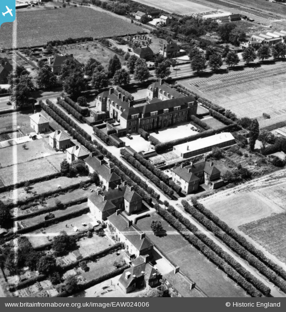
EAW024006 ENGLAND (1949). Howes Place and the National Institute of Agricultural Botany (Official Seed Testing Station), Cambridge, 1949. This image has been produced from a print marked by Aerofilms Ltd for photo editing.
© Copyright OpenStreetMap contributors and licensed by the OpenStreetMap Foundation. 2026. Cartography is licensed as CC BY-SA.
Nearby Images (6)
EAW024006
, Cambridge, 1949. This image has been produced from a print marked by Aerofilms Ltd for photo editing.")
EAW024001
, Cambridge, 1949. This image has been produced from a print marked by Aerofilms Ltd for photo editing.")
EAW024002
, Cambridge, 1949. This image has been produced from a print marked by Aerofilms Ltd for photo editing.")
EAW024004
, Cambridge, 1949. This image has been produced from a print marked by Aerofilms Ltd for photo editing.")
EAW024003
, Cambridge, 1949. This image has been produced from a print.")
EAW023999
, Cambridge, 1949. This image has been produced from a print marked by Aerofilms Ltd for photo editing.")
Details
| Title | [EAW024006] Howes Place and the National Institute of Agricultural Botany (Official Seed Testing Station), Cambridge, 1949. This image has been produced from a print marked by Aerofilms Ltd for photo editing. |
| Reference | EAW024006 |
| Date | 23-June-1949 |
| Link | |
| Place name | CAMBRIDGE |
| Parish | |
| District | |
| Country | ENGLAND |
| Easting / Northing | 543328, 260285 |
| Longitude / Latitude | 0.098490273011735, 52.22169891514 |
| National Grid Reference | TL433603 |
Pins
Be the first to add a comment to this image!