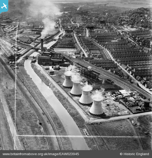
EAW023945 ENGLAND (1949). Spa Road Power Station, Lincoln, 1949. This image was marked by Aerofilms Ltd for photo editing.
© Copyright OpenStreetMap contributors and licensed by the OpenStreetMap Foundation. 2026. Cartography is licensed as CC BY-SA.
Nearby Images (10)
Details
| Title | [EAW023945] Spa Road Power Station, Lincoln, 1949. This image was marked by Aerofilms Ltd for photo editing. |
| Reference | EAW023945 |
| Date | 20-June-1949 |
| Link | |
| Place name | LINCOLN |
| Parish | |
| District | |
| Country | ENGLAND |
| Easting / Northing | 498745, 371127 |
| Longitude / Latitude | -0.52063479261515, 53.227712722009 |
| National Grid Reference | SK987711 |


![[EAW023945] Spa Road Power Station, Lincoln, 1949. This image was marked by Aerofilms Ltd for photo editing.](http://britainfromabove.org.uk/sites/all/libraries/aerofilms-images/public/100x100/EAW/023/EAW023945.jpg)
![[EAW023939] Spa Road Power Station, Lincoln, 1949. This image was marked by Aerofilms Ltd for photo editing.](http://britainfromabove.org.uk/sites/all/libraries/aerofilms-images/public/100x100/EAW/023/EAW023939.jpg)
![[EAW023942] Spa Road Power Station, Lincoln, 1949. This image was marked by Aerofilms Ltd for photo editing.](http://britainfromabove.org.uk/sites/all/libraries/aerofilms-images/public/100x100/EAW/023/EAW023942.jpg)
![[EAW023946] Spa Road Power Station, Lincoln, 1949](http://britainfromabove.org.uk/sites/all/libraries/aerofilms-images/public/100x100/EAW/023/EAW023946.jpg)
![[EAW023938] Spa Road Power Station, Lincoln, 1949. This image has been produced from a damaged negative.](http://britainfromabove.org.uk/sites/all/libraries/aerofilms-images/public/100x100/EAW/023/EAW023938.jpg)
![[EAW023947] Spa Road Power Station, Lincoln, 1949. This image was marked by Aerofilms Ltd for photo editing.](http://britainfromabove.org.uk/sites/all/libraries/aerofilms-images/public/100x100/EAW/023/EAW023947.jpg)
![[EAW023941] Spa Road Power Station, Lincoln, 1949. This image was marked by Aerofilms Ltd for photo editing.](http://britainfromabove.org.uk/sites/all/libraries/aerofilms-images/public/100x100/EAW/023/EAW023941.jpg)
![[EAW023944] Spa Road Power Station, Lincoln, 1949. This image was marked by Aerofilms Ltd for photo editing.](http://britainfromabove.org.uk/sites/all/libraries/aerofilms-images/public/100x100/EAW/023/EAW023944.jpg)
![[EAW023943] Spa Road Power Station, Lincoln, from the south, 1949](http://britainfromabove.org.uk/sites/all/libraries/aerofilms-images/public/100x100/EAW/023/EAW023943.jpg)
![[EAW023940] Spa Road Power Station, Lincoln, from the south-west, 1949. This image was marked by Aerofilms Ltd for photo editing.](http://britainfromabove.org.uk/sites/all/libraries/aerofilms-images/public/100x100/EAW/023/EAW023940.jpg)
