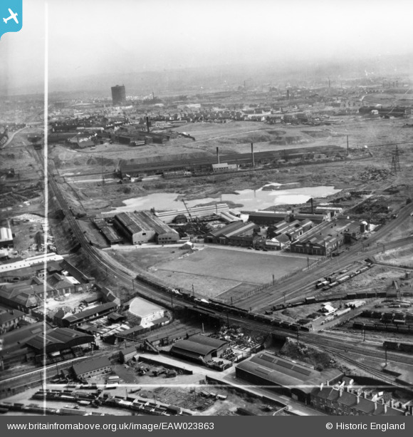
EAW023863 ENGLAND (1949). The Hilltop Foundry Co Ltd Anchor Works, Wednesbury, from the north-east, 1949. This image was marked by Aerofilms Ltd for photo editing.
© Copyright OpenStreetMap contributors and licensed by the OpenStreetMap Foundation. 2026. Cartography is licensed as CC BY-SA.
Nearby Images (6)
Details
| Title | [EAW023863] The Hilltop Foundry Co Ltd Anchor Works, Wednesbury, from the north-east, 1949. This image was marked by Aerofilms Ltd for photo editing. |
| Reference | EAW023863 |
| Date | 15-June-1949 |
| Link | |
| Place name | WEDNESBURY |
| Parish | |
| District | |
| Country | ENGLAND |
| Easting / Northing | 398559, 294357 |
| Longitude / Latitude | -2.0212522467988, 52.546699914806 |
| National Grid Reference | SO986944 |
Pins

Rob |
Thursday 28th of September 2023 12:03:04 PM | |

DaveT |
Friday 2nd of January 2015 07:19:09 PM | |

DaveT |
Friday 2nd of January 2015 07:19:04 PM | |

Jim Croton |
Tuesday 1st of July 2014 05:15:01 PM | |

Jim Croton |
Tuesday 1st of July 2014 05:03:34 PM | |

Steve P |
Thursday 3rd of April 2014 11:57:53 AM | |

Steve P |
Thursday 3rd of April 2014 11:56:56 AM | |

Steve P |
Thursday 3rd of April 2014 11:55:29 AM | |

Steve P |
Thursday 3rd of April 2014 11:54:11 AM | |

Martin |
Monday 20th of January 2014 05:24:46 PM | |
That's at the top end of the Ball's Hill Branch Canal |

Steve P |
Thursday 3rd of April 2014 11:50:38 AM |


![[EAW023863] The Hilltop Foundry Co Ltd Anchor Works, Wednesbury, from the north-east, 1949. This image was marked by Aerofilms Ltd for photo editing.](http://britainfromabove.org.uk/sites/all/libraries/aerofilms-images/public/100x100/EAW/023/EAW023863.jpg)
![[EAW023861] The Hilltop Foundry Co Ltd Anchor Works and environs, Wednesbury, from the north-east, 1949. This image has been produced from a print marked by Aerofilms Ltd for photo editing.](http://britainfromabove.org.uk/sites/all/libraries/aerofilms-images/public/100x100/EAW/023/EAW023861.jpg)
![[EAW023862] The Hilltop Foundry Co Ltd Anchor Works and environs, Wednesbury, 1949. This image has been produced from a damaged negative.](http://britainfromabove.org.uk/sites/all/libraries/aerofilms-images/public/100x100/EAW/023/EAW023862.jpg)
![[EAW023866] The Hilltop Foundry Co Ltd Anchor Works, Wednesbury, from the north-west, 1949](http://britainfromabove.org.uk/sites/all/libraries/aerofilms-images/public/100x100/EAW/023/EAW023866.jpg)
![[EAW023864] The Hilltop Foundry Co Ltd Anchor Works, Wednesbury, 1949](http://britainfromabove.org.uk/sites/all/libraries/aerofilms-images/public/100x100/EAW/023/EAW023864.jpg)
![[EAW023865] The Hilltop Foundry Co Ltd Anchor Works, Wednesbury, 1949. This image was marked by Aerofilms Ltd for photo editing.](http://britainfromabove.org.uk/sites/all/libraries/aerofilms-images/public/100x100/EAW/023/EAW023865.jpg)