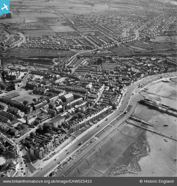
EAW023410 ENGLAND (1949). Marine Road Central and environs, Morecombe, 1949
© Copyright OpenStreetMap contributors and licensed by the OpenStreetMap Foundation. 2026. Cartography is licensed as CC BY-SA.
Nearby Images (5)
Details
| Title | [EAW023410] Marine Road Central and environs, Morecombe, 1949 |
| Reference | EAW023410 |
| Date | 25-May-1949 |
| Link | |
| Place name | MORECOMBE |
| Parish | MORECAMBE |
| District | |
| Country | ENGLAND |
| Easting / Northing | 343586, 464515 |
| Longitude / Latitude | -2.8622398692924, 54.073289498098 |
| National Grid Reference | SD436645 |
Pins

Bert |
Saturday 14th of September 2024 04:14:26 PM | |

redmist |
Saturday 5th of December 2020 09:33:39 PM | |

redmist |
Saturday 5th of December 2020 09:32:47 PM | |

LankyBod |
Sunday 24th of April 2016 02:09:53 AM | |

Joe |
Tuesday 27th of January 2015 07:24:21 PM | |

gBr |
Saturday 10th of January 2015 10:19:15 PM | |

gBr |
Saturday 10th of January 2015 10:15:41 PM | |

powerpop |
Tuesday 14th of October 2014 10:45:26 PM | |
Promenade Station, ex Midland Railway. |

gBr |
Saturday 10th of January 2015 10:17:20 PM |

wadey |
Tuesday 26th of August 2014 09:41:42 PM |
User Comment Contributions
Should be Morecambe - not Morecombe... |

Woodzmeister |
Monday 3rd of March 2014 08:58:53 PM |


![[EAW023410] Marine Road Central and environs, Morecombe, 1949](http://britainfromabove.org.uk/sites/all/libraries/aerofilms-images/public/100x100/EAW/023/EAW023410.jpg)
![[EPW042132] Morecambe Harbour, Central Pier and the town, Morecambe, 1933](http://britainfromabove.org.uk/sites/all/libraries/aerofilms-images/public/100x100/EPW/042/EPW042132.jpg)
![[EAW023411] The Central Pier, Morecombe, 1949](http://britainfromabove.org.uk/sites/all/libraries/aerofilms-images/public/100x100/EAW/023/EAW023411.jpg)
![[EPW042137] Central Pier, Morecambe, 1933](http://britainfromabove.org.uk/sites/all/libraries/aerofilms-images/public/100x100/EPW/042/EPW042137.jpg)
![[EPW042129] Central Pier, Morecambe, 1933](http://britainfromabove.org.uk/sites/all/libraries/aerofilms-images/public/100x100/EPW/042/EPW042129.jpg)