
EAW022843 ENGLAND (1949). Dunstanburgh Castle and Castle Point, Craster, 1949

© Copyright OpenStreetMap contributors and licensed by the OpenStreetMap Foundation. 2026. Cartography is licensed as CC BY-SA.
Nearby Images (11)
EAW022843

EAW006080

EAW006081

EAW006079

EAW006077

EAW022840

EAW022839

EAW022841

EAW006078

EAW022842

EAW022844

Details
| Title | [EAW022843] Dunstanburgh Castle and Castle Point, Craster, 1949 |
| Reference | EAW022843 |
| Date | 30-May-1949 |
| Link | |
| Place name | CRASTER |
| Parish | CRASTER |
| District | |
| Country | ENGLAND |
| Easting / Northing | 425713, 621895 |
| Longitude / Latitude | -1.5930202450446, 55.490162349797 |
| National Grid Reference | NU257219 |
Pins

redmist |
Saturday 29th of April 2023 09:40:44 PM | |
|
redmist |
Saturday 29th of April 2023 09:40:07 PM | |

Matt Aldred edob.mattaldred.com |
Tuesday 9th of March 2021 02:39:20 PM | |
|
Matt Aldred edob.mattaldred.com |
Tuesday 9th of March 2021 02:39:07 PM | |
|
redmist |
Saturday 2nd of November 2019 10:15:30 PM | |
|
redmist |
Saturday 2nd of November 2019 10:14:36 PM | |
|
totoro |
Friday 17th of July 2015 10:26:25 PM | |
|
totoro |
Friday 17th of July 2015 10:24:22 PM | |
|
totoro |
Friday 17th of July 2015 10:21:56 PM | |
|
totoro |
Friday 17th of July 2015 10:19:47 PM | |
|
totoro |
Friday 17th of July 2015 10:17:43 PM | |
|
totoro |
Friday 17th of July 2015 10:15:18 PM | |
|
totoro |
Friday 17th of July 2015 10:12:59 PM | |
|
totoro |
Friday 17th of July 2015 10:10:52 PM | |
|
totoro |
Friday 17th of July 2015 10:07:55 PM | |
|
Al |
Monday 22nd of December 2014 10:27:38 AM |
User Comment Contributions
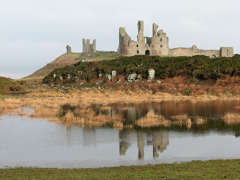
Nearest postcode NE66 3TT Grade 1 listed building - English Heritage Building ID: 236942 Scheduled Ancient Monument Northumberland 3 Built by Earl Thomas of Lancaster between 1313 and 1322 - he was captured at the Battle of Boroughbridge as he attempted to flee royal forces for the safety of Dunstanburgh. The fortress never recovered from the sieges of the Wars of the Roses and was badly decayed by the 16th C. Placed into the guardianship of the state in 1930. The surrounding golf course dates from 1900. Now owned by the National Trust and run by English Heritage. A nearby stone quay remains from a harbour built to serve the castle. Generally open to the public for a fee, (weekends only Nov-Feb) 2010 photograph by and copyright John Sutton, used under Creative Commons Attribution-ShareAlike 2.0 license, source [[File:Dunstanburgh Castle - geograph.org.uk - 1716666.jpg]] Sources: wikipedia [[Dunstanburgh Castle]] National Trust (http://www.nationaltrust.org.uk/dunstanburgh-castle/) English Heritage (http://www.english-heritage.org.uk/visit/places/dunstanburgh-castle/) |
totoro |
Friday 17th of July 2015 10:05:11 PM |