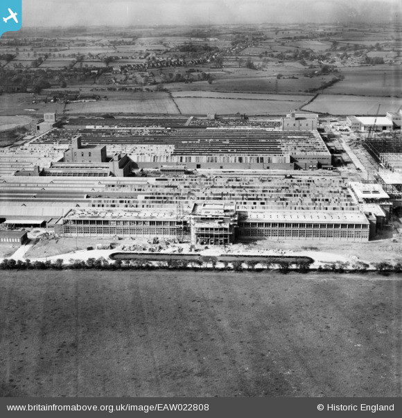
EAW022808 ENGLAND (1949). Patons and Baldwin's Wool Factory under construction at Lingfield Point and environs, Lingfield, from the south, 1949
© Copyright OpenStreetMap contributors and licensed by the OpenStreetMap Foundation. 2026. Cartography is licensed as CC BY-SA.
Nearby Images (36)
Details
| Title | [EAW022808] Patons and Baldwin's Wool Factory under construction at Lingfield Point and environs, Lingfield, from the south, 1949 |
| Reference | EAW022808 |
| Date | 30-April-1949 |
| Link | |
| Place name | LINGFIELD |
| Parish | |
| District | |
| Country | ENGLAND |
| Easting / Northing | 431525, 514721 |
| Longitude / Latitude | -1.5128480104926, 54.526662781602 |
| National Grid Reference | NZ315147 |
Pins
Be the first to add a comment to this image!


![[EAW022808] Patons and Baldwin's Wool Factory under construction at Lingfield Point and environs, Lingfield, from the south, 1949](http://britainfromabove.org.uk/sites/all/libraries/aerofilms-images/public/100x100/EAW/022/EAW022808.jpg)
![[EAW027447] The Patons and Baldwins Worsted Spinning Mill, Darlington, from the south, 1949](http://britainfromabove.org.uk/sites/all/libraries/aerofilms-images/public/100x100/EAW/027/EAW027447.jpg)
![[EAW022802] Patons and Baldwin's Wool Factory under construction at Lingfield Point and environs, Lingfield, from the south, 1949](http://britainfromabove.org.uk/sites/all/libraries/aerofilms-images/public/100x100/EAW/022/EAW022802.jpg)
![[EAW022817] Patons and Baldwin's Wool Factory under construction at Lingfield Point, Lingfield, 1949](http://britainfromabove.org.uk/sites/all/libraries/aerofilms-images/public/100x100/EAW/022/EAW022817.jpg)
![[EAW017433] The Patons and Baldwins Worsted Spinning Mill under construction, Darlington, 1948. This image has been produced from a print.](http://britainfromabove.org.uk/sites/all/libraries/aerofilms-images/public/100x100/EAW/017/EAW017433.jpg)
![[EAW017432] The Patons and Baldwins Worsted Spinning Mill under construction, Darlington, from the south, 1948. This image has been produced from a print.](http://britainfromabove.org.uk/sites/all/libraries/aerofilms-images/public/100x100/EAW/017/EAW017432.jpg)
![[EAW034281] The Patons and Baldwins Worsted Spinning Mill, Darlington, 1950. This image has been produced from a print marked by Aerofilms Ltd for photo editing.](http://britainfromabove.org.uk/sites/all/libraries/aerofilms-images/public/100x100/EAW/034/EAW034281.jpg)
![[EAW017436] The Patons and Baldwins Worsted Spinning Mill under construction, Darlington, from the south-east, 1948. This image has been produced from a print.](http://britainfromabove.org.uk/sites/all/libraries/aerofilms-images/public/100x100/EAW/017/EAW017436.jpg)
![[EAW017437] The Patons and Baldwins Worsted Spinning Mill under construction, Darlington, from the south-east, 1948. This image has been produced from a print.](http://britainfromabove.org.uk/sites/all/libraries/aerofilms-images/public/100x100/EAW/017/EAW017437.jpg)
![[EAW034282] The Patons and Baldwins Worsted Spinning Mill, Darlington, 1950. This image has been produced from a print marked by Aerofilms Ltd for photo editing.](http://britainfromabove.org.uk/sites/all/libraries/aerofilms-images/public/100x100/EAW/034/EAW034282.jpg)
![[EAW022812] Patons and Baldwin's Wool Factory under construction at Lingfield Point, Lingfield, 1949](http://britainfromabove.org.uk/sites/all/libraries/aerofilms-images/public/100x100/EAW/022/EAW022812.jpg)
![[EAW022814] Patons and Baldwin's Wool Factory under construction at Lingfield Point, Lingfield, from the south-east, 1949](http://britainfromabove.org.uk/sites/all/libraries/aerofilms-images/public/100x100/EAW/022/EAW022814.jpg)
![[EAW022804] Patons and Baldwin's Wool Factory under construction at Lingfield Point, Lingfield, 1949](http://britainfromabove.org.uk/sites/all/libraries/aerofilms-images/public/100x100/EAW/022/EAW022804.jpg)
![[EAW027433] The Patons and Baldwins Worsted Spinning Mill, Darlington, 1949. This image was marked by Aerofilms Ltd for photo editing.](http://britainfromabove.org.uk/sites/all/libraries/aerofilms-images/public/100x100/EAW/027/EAW027433.jpg)
![[EAW023502] Patons & Baldwins Worsted Spinning Mill, Darlington, 1949](http://britainfromabove.org.uk/sites/all/libraries/aerofilms-images/public/100x100/EAW/023/EAW023502.jpg)
![[EAW027444] The Patons and Baldwins Worsted Spinning Mill, Darlington, 1949](http://britainfromabove.org.uk/sites/all/libraries/aerofilms-images/public/100x100/EAW/027/EAW027444.jpg)
![[EAW022805] Patons and Baldwin's Wool Factory under construction at Lingfield Point and environs, Lingfield, from the south, 1949](http://britainfromabove.org.uk/sites/all/libraries/aerofilms-images/public/100x100/EAW/022/EAW022805.jpg)
![[EAW022815] Patons and Baldwin's Wool Factory under construction at Lingfield Point, Lingfield, 1949](http://britainfromabove.org.uk/sites/all/libraries/aerofilms-images/public/100x100/EAW/022/EAW022815.jpg)
![[EAW017435] The Patons and Baldwins Worsted Spinning Mill under construction, Darlington, 1948. This image has been produced from a print.](http://britainfromabove.org.uk/sites/all/libraries/aerofilms-images/public/100x100/EAW/017/EAW017435.jpg)
![[EAW027439] The Patons and Baldwins Worsted Spinning Mill, Darlington, from the south-east, 1949](http://britainfromabove.org.uk/sites/all/libraries/aerofilms-images/public/100x100/EAW/027/EAW027439.jpg)
![[EAW027457] The Patons and Baldwins Worsted Spinning Mill, Darlington, 1949. This image was marked by Aerofilms Ltd for photo editing.](http://britainfromabove.org.uk/sites/all/libraries/aerofilms-images/public/100x100/EAW/027/EAW027457.jpg)
![[EAW017429] The Patons and Baldwins Worsted Spinning Mill under construction, Darlington, 1948. This image has been produced from a print.](http://britainfromabove.org.uk/sites/all/libraries/aerofilms-images/public/100x100/EAW/017/EAW017429.jpg)
![[EAW007626] Patons and Baldwins Wool Factory at Lingfield Point under construction, Darlington, 1947](http://britainfromabove.org.uk/sites/all/libraries/aerofilms-images/public/100x100/EAW/007/EAW007626.jpg)
![[EAW034277] The Patons and Baldwins Worsted Spinning Mill, Darlington, 1950. This image has been produced from a print marked by Aerofilms Ltd for photo editing.](http://britainfromabove.org.uk/sites/all/libraries/aerofilms-images/public/100x100/EAW/034/EAW034277.jpg)
![[EAW017438] The Patons and Baldwins Worsted Spinning Mill under construction, Darlington, 1948. This image has been produced from a print.](http://britainfromabove.org.uk/sites/all/libraries/aerofilms-images/public/100x100/EAW/017/EAW017438.jpg)
![[EAW027452] The Patons and Baldwins Worsted Spinning Mill, Darlington, 1949. This image was marked by Aerofilms Ltd for photo editing.](http://britainfromabove.org.uk/sites/all/libraries/aerofilms-images/public/100x100/EAW/027/EAW027452.jpg)
![[EAW034279] The Patons and Baldwins Worsted Spinning Mill, Darlington, 1950. This image has been produced from a print marked by Aerofilms Ltd for photo editing.](http://britainfromabove.org.uk/sites/all/libraries/aerofilms-images/public/100x100/EAW/034/EAW034279.jpg)
![[EAW027437] The Patons and Baldwins Worsted Spinning Mill, Darlington, 1949](http://britainfromabove.org.uk/sites/all/libraries/aerofilms-images/public/100x100/EAW/027/EAW027437.jpg)
![[EAW023497] Patons & Baldwins Worsted Spinning Mill, Darlington, 1949](http://britainfromabove.org.uk/sites/all/libraries/aerofilms-images/public/100x100/EAW/023/EAW023497.jpg)
![[EAW007625] Patons and Baldwins Wool Factory at Lingfield Point under construction, Darlington, 1947](http://britainfromabove.org.uk/sites/all/libraries/aerofilms-images/public/100x100/EAW/007/EAW007625.jpg)
![[EAW034278] The Patons and Baldwins Worsted Spinning Mill, Darlington, 1950. This image has been produced from a print marked by Aerofilms Ltd for photo editing.](http://britainfromabove.org.uk/sites/all/libraries/aerofilms-images/public/100x100/EAW/034/EAW034278.jpg)
![[EAW022816] Patons and Baldwin's Wool Factory under construction at Lingfield Point, Lingfield, 1949](http://britainfromabove.org.uk/sites/all/libraries/aerofilms-images/public/100x100/EAW/022/EAW022816.jpg)
![[EAW027450] The Patons and Baldwins Worsted Spinning Mill, Darlington, 1949](http://britainfromabove.org.uk/sites/all/libraries/aerofilms-images/public/100x100/EAW/027/EAW027450.jpg)
![[EAW034276] The Patons and Baldwins Worsted Spinning Mill, Darlington, 1950. This image has been produced from a print marked by Aerofilms Ltd for photo editing.](http://britainfromabove.org.uk/sites/all/libraries/aerofilms-images/public/100x100/EAW/034/EAW034276.jpg)
![[EAW022811] Patons and Baldwin's Wool Factory under construction at Lingfield Point, Lingfield, 1949](http://britainfromabove.org.uk/sites/all/libraries/aerofilms-images/public/100x100/EAW/022/EAW022811.jpg)
![[EAW017431] The Patons and Baldwins Worsted Spinning Mill under construction, Darlington, from the south-west, 1948. This image has been produced from a print.](http://britainfromabove.org.uk/sites/all/libraries/aerofilms-images/public/100x100/EAW/017/EAW017431.jpg)