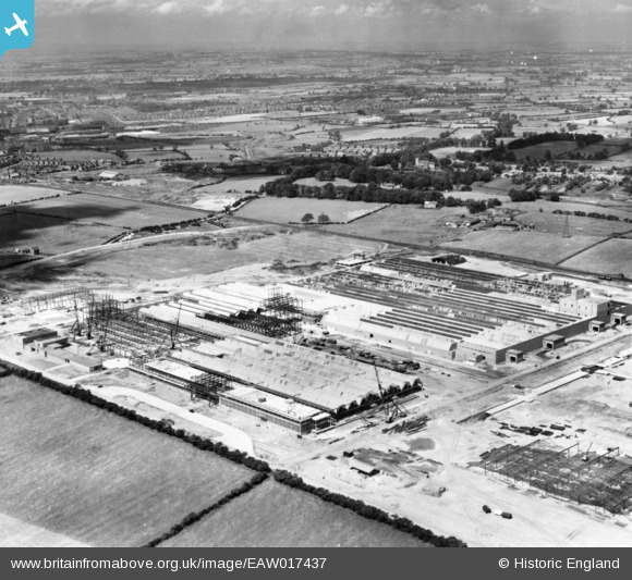
EAW017437 ENGLAND (1948). The Patons and Baldwins Worsted Spinning Mill under construction, Darlington, from the south-east, 1948. This image has been produced from a print.
© Copyright OpenStreetMap contributors and licensed by the OpenStreetMap Foundation. 2026. Cartography is licensed as CC BY-SA.
Nearby Images (48)
Details
| Title | [EAW017437] The Patons and Baldwins Worsted Spinning Mill under construction, Darlington, from the south-east, 1948. This image has been produced from a print. |
| Reference | EAW017437 |
| Date | 24-July-1948 |
| Link | |
| Place name | DARLINGTON |
| Parish | |
| District | |
| Country | ENGLAND |
| Easting / Northing | 431621, 514829 |
| Longitude / Latitude | -1.5113530026462, 54.527627458291 |
| National Grid Reference | NZ316148 |
Pins
Be the first to add a comment to this image!


![[EAW017437] The Patons and Baldwins Worsted Spinning Mill under construction, Darlington, from the south-east, 1948. This image has been produced from a print.](http://britainfromabove.org.uk/sites/all/libraries/aerofilms-images/public/100x100/EAW/017/EAW017437.jpg)
![[EAW017436] The Patons and Baldwins Worsted Spinning Mill under construction, Darlington, from the south-east, 1948. This image has been produced from a print.](http://britainfromabove.org.uk/sites/all/libraries/aerofilms-images/public/100x100/EAW/017/EAW017436.jpg)
![[EAW022814] Patons and Baldwin's Wool Factory under construction at Lingfield Point, Lingfield, from the south-east, 1949](http://britainfromabove.org.uk/sites/all/libraries/aerofilms-images/public/100x100/EAW/022/EAW022814.jpg)
![[EAW022804] Patons and Baldwin's Wool Factory under construction at Lingfield Point, Lingfield, 1949](http://britainfromabove.org.uk/sites/all/libraries/aerofilms-images/public/100x100/EAW/022/EAW022804.jpg)
![[EAW022812] Patons and Baldwin's Wool Factory under construction at Lingfield Point, Lingfield, 1949](http://britainfromabove.org.uk/sites/all/libraries/aerofilms-images/public/100x100/EAW/022/EAW022812.jpg)
![[EAW034281] The Patons and Baldwins Worsted Spinning Mill, Darlington, 1950. This image has been produced from a print marked by Aerofilms Ltd for photo editing.](http://britainfromabove.org.uk/sites/all/libraries/aerofilms-images/public/100x100/EAW/034/EAW034281.jpg)
![[EAW034282] The Patons and Baldwins Worsted Spinning Mill, Darlington, 1950. This image has been produced from a print marked by Aerofilms Ltd for photo editing.](http://britainfromabove.org.uk/sites/all/libraries/aerofilms-images/public/100x100/EAW/034/EAW034282.jpg)
![[EAW017433] The Patons and Baldwins Worsted Spinning Mill under construction, Darlington, 1948. This image has been produced from a print.](http://britainfromabove.org.uk/sites/all/libraries/aerofilms-images/public/100x100/EAW/017/EAW017433.jpg)
![[EAW027433] The Patons and Baldwins Worsted Spinning Mill, Darlington, 1949. This image was marked by Aerofilms Ltd for photo editing.](http://britainfromabove.org.uk/sites/all/libraries/aerofilms-images/public/100x100/EAW/027/EAW027433.jpg)
![[EAW022817] Patons and Baldwin's Wool Factory under construction at Lingfield Point, Lingfield, 1949](http://britainfromabove.org.uk/sites/all/libraries/aerofilms-images/public/100x100/EAW/022/EAW022817.jpg)
![[EAW027452] The Patons and Baldwins Worsted Spinning Mill, Darlington, 1949. This image was marked by Aerofilms Ltd for photo editing.](http://britainfromabove.org.uk/sites/all/libraries/aerofilms-images/public/100x100/EAW/027/EAW027452.jpg)
![[EAW017429] The Patons and Baldwins Worsted Spinning Mill under construction, Darlington, 1948. This image has been produced from a print.](http://britainfromabove.org.uk/sites/all/libraries/aerofilms-images/public/100x100/EAW/017/EAW017429.jpg)
![[EAW023502] Patons & Baldwins Worsted Spinning Mill, Darlington, 1949](http://britainfromabove.org.uk/sites/all/libraries/aerofilms-images/public/100x100/EAW/023/EAW023502.jpg)
![[EAW007626] Patons and Baldwins Wool Factory at Lingfield Point under construction, Darlington, 1947](http://britainfromabove.org.uk/sites/all/libraries/aerofilms-images/public/100x100/EAW/007/EAW007626.jpg)
![[EAW027444] The Patons and Baldwins Worsted Spinning Mill, Darlington, 1949](http://britainfromabove.org.uk/sites/all/libraries/aerofilms-images/public/100x100/EAW/027/EAW027444.jpg)
![[EAW034279] The Patons and Baldwins Worsted Spinning Mill, Darlington, 1950. This image has been produced from a print marked by Aerofilms Ltd for photo editing.](http://britainfromabove.org.uk/sites/all/libraries/aerofilms-images/public/100x100/EAW/034/EAW034279.jpg)
![[EAW007625] Patons and Baldwins Wool Factory at Lingfield Point under construction, Darlington, 1947](http://britainfromabove.org.uk/sites/all/libraries/aerofilms-images/public/100x100/EAW/007/EAW007625.jpg)
![[EAW022808] Patons and Baldwin's Wool Factory under construction at Lingfield Point and environs, Lingfield, from the south, 1949](http://britainfromabove.org.uk/sites/all/libraries/aerofilms-images/public/100x100/EAW/022/EAW022808.jpg)
![[EAW017432] The Patons and Baldwins Worsted Spinning Mill under construction, Darlington, from the south, 1948. This image has been produced from a print.](http://britainfromabove.org.uk/sites/all/libraries/aerofilms-images/public/100x100/EAW/017/EAW017432.jpg)
![[EAW027447] The Patons and Baldwins Worsted Spinning Mill, Darlington, from the south, 1949](http://britainfromabove.org.uk/sites/all/libraries/aerofilms-images/public/100x100/EAW/027/EAW027447.jpg)
![[EAW007630] Patons and Baldwins Wool Factory at Lingfield Point under construction, Darlington, 1947](http://britainfromabove.org.uk/sites/all/libraries/aerofilms-images/public/100x100/EAW/007/EAW007630.jpg)
![[EAW013818] Construction of Paton and Baldwins Worsted Spinning Mill at Lingfield Point, Lingfield, 1948](http://britainfromabove.org.uk/sites/all/libraries/aerofilms-images/public/100x100/EAW/013/EAW013818.jpg)
![[EAW007624] Patons and Baldwins Wool Factory at Lingfield Point under construction, Darlington, 1947](http://britainfromabove.org.uk/sites/all/libraries/aerofilms-images/public/100x100/EAW/007/EAW007624.jpg)
![[EAW022802] Patons and Baldwin's Wool Factory under construction at Lingfield Point and environs, Lingfield, from the south, 1949](http://britainfromabove.org.uk/sites/all/libraries/aerofilms-images/public/100x100/EAW/022/EAW022802.jpg)
![[EAW007631] Patons and Baldwins Wool Factory at Lingfield Point under construction, Darlington, 1947](http://britainfromabove.org.uk/sites/all/libraries/aerofilms-images/public/100x100/EAW/007/EAW007631.jpg)
![[EAW027436] The Patons and Baldwins Worsted Spinning Mill, Darlington, 1949. This image was marked by Aerofilms Ltd for photo editing.](http://britainfromabove.org.uk/sites/all/libraries/aerofilms-images/public/100x100/EAW/027/EAW027436.jpg)
![[EAW007632] Patons and Baldwins Wool Factory at Lingfield Point under construction, Darlington, 1947](http://britainfromabove.org.uk/sites/all/libraries/aerofilms-images/public/100x100/EAW/007/EAW007632.jpg)
![[EAW007636] Patons and Baldwins Wool Factory at Lingfield Point under construction, Darlington, 1947](http://britainfromabove.org.uk/sites/all/libraries/aerofilms-images/public/100x100/EAW/007/EAW007636.jpg)
![[EAW007635] Patons and Baldwins Wool Factory at Lingfield Point under construction, Darlington, 1947](http://britainfromabove.org.uk/sites/all/libraries/aerofilms-images/public/100x100/EAW/007/EAW007635.jpg)
![[EAW027454] Part of the Patons and Baldwins Worsted Spinning Mill under construction, Darlington, 1949. This image was marked by Aerofilms Ltd for photo editing.](http://britainfromabove.org.uk/sites/all/libraries/aerofilms-images/public/100x100/EAW/027/EAW027454.jpg)
![[EAW022810] Patons and Baldwin's Wool Factory under construction at Lingfield Point, Lingfield, 1949](http://britainfromabove.org.uk/sites/all/libraries/aerofilms-images/public/100x100/EAW/022/EAW022810.jpg)
![[EAW022815] Patons and Baldwin's Wool Factory under construction at Lingfield Point, Lingfield, 1949](http://britainfromabove.org.uk/sites/all/libraries/aerofilms-images/public/100x100/EAW/022/EAW022815.jpg)
![[EAW034280] The Patons and Baldwins Worsted Spinning Mill, Darlington, 1950. This image has been produced from a print marked by Aerofilms Ltd for photo editing.](http://britainfromabove.org.uk/sites/all/libraries/aerofilms-images/public/100x100/EAW/034/EAW034280.jpg)
![[EAW007637] Patons and Baldwins Wool Factory at Lingfield Point under construction, Darlington, 1947](http://britainfromabove.org.uk/sites/all/libraries/aerofilms-images/public/100x100/EAW/007/EAW007637.jpg)
![[EAW034272] The Patons and Baldwins Worsted Spinning Mill, Darlington, 1950. This image has been produced from a print marked by Aerofilms Ltd for photo editing.](http://britainfromabove.org.uk/sites/all/libraries/aerofilms-images/public/100x100/EAW/034/EAW034272.jpg)
![[EAW027457] The Patons and Baldwins Worsted Spinning Mill, Darlington, 1949. This image was marked by Aerofilms Ltd for photo editing.](http://britainfromabove.org.uk/sites/all/libraries/aerofilms-images/public/100x100/EAW/027/EAW027457.jpg)
![[EAW017430] The Patons and Baldwins Worsted Spinning Mill under construction, Darlington, 1948. This image has been produced from a print.](http://britainfromabove.org.uk/sites/all/libraries/aerofilms-images/public/100x100/EAW/017/EAW017430.jpg)
![[EAW027442] The Patons and Baldwins Worsted Spinning Mill, Darlington, 1949](http://britainfromabove.org.uk/sites/all/libraries/aerofilms-images/public/100x100/EAW/027/EAW027442.jpg)
![[EAW023497] Patons & Baldwins Worsted Spinning Mill, Darlington, 1949](http://britainfromabove.org.uk/sites/all/libraries/aerofilms-images/public/100x100/EAW/023/EAW023497.jpg)
![[EAW013819] Construction of Paton and Baldwins Worsted Spinning Mill at Lingfield Point, Lingfield, 1948](http://britainfromabove.org.uk/sites/all/libraries/aerofilms-images/public/100x100/EAW/013/EAW013819.jpg)
![[EAW017435] The Patons and Baldwins Worsted Spinning Mill under construction, Darlington, 1948. This image has been produced from a print.](http://britainfromabove.org.uk/sites/all/libraries/aerofilms-images/public/100x100/EAW/017/EAW017435.jpg)
![[EAW017438] The Patons and Baldwins Worsted Spinning Mill under construction, Darlington, 1948. This image has been produced from a print.](http://britainfromabove.org.uk/sites/all/libraries/aerofilms-images/public/100x100/EAW/017/EAW017438.jpg)
![[EAW017428] The Patons and Baldwins Worsted Spinning Mill under construction, Darlington, 1948. This image has been produced from a print.](http://britainfromabove.org.uk/sites/all/libraries/aerofilms-images/public/100x100/EAW/017/EAW017428.jpg)
![[EAW027437] The Patons and Baldwins Worsted Spinning Mill, Darlington, 1949](http://britainfromabove.org.uk/sites/all/libraries/aerofilms-images/public/100x100/EAW/027/EAW027437.jpg)
![[EAW023501] Patons & Baldwins Worsted Spinning Mill, Darlington, 1949](http://britainfromabove.org.uk/sites/all/libraries/aerofilms-images/public/100x100/EAW/023/EAW023501.jpg)
![[EAW034273] The Patons and Baldwins Worsted Spinning Mill, Darlington, 1950. This image has been produced from a print marked by Aerofilms Ltd for photo editing.](http://britainfromabove.org.uk/sites/all/libraries/aerofilms-images/public/100x100/EAW/034/EAW034273.jpg)
![[EAW023503] Patons & Baldwins Worsted Spinning Mill, Darlington, 1949. This image has been produced from a print marked by Aerofilms Ltd for photo editing.](http://britainfromabove.org.uk/sites/all/libraries/aerofilms-images/public/100x100/EAW/023/EAW023503.jpg)
![[EAW023504] Patons & Baldwins Worsted Spinning Mill, Darlington, 1949. This image has been produced from a print marked by Aerofilms Ltd for photo editing.](http://britainfromabove.org.uk/sites/all/libraries/aerofilms-images/public/100x100/EAW/023/EAW023504.jpg)