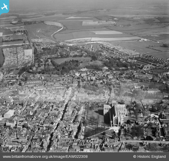
EAW022308 ENGLAND (1949). The High Street and Cathedral of the Holy Trinity looking towards St Giles's Hill, Winchester, from the west, 1949
© Copyright OpenStreetMap contributors and licensed by the OpenStreetMap Foundation. 2026. Cartography is licensed as CC BY-SA.
Nearby Images (21)
Details
| Title | [EAW022308] The High Street and Cathedral of the Holy Trinity looking towards St Giles's Hill, Winchester, from the west, 1949 |
| Reference | EAW022308 |
| Date | 18-April-1949 |
| Link | |
| Place name | WINCHESTER |
| Parish | |
| District | |
| Country | ENGLAND |
| Easting / Northing | 448316, 129332 |
| Longitude / Latitude | -1.3104692645846, 51.060756611711 |
| National Grid Reference | SU483293 |
Pins

redmist |
Saturday 23rd of December 2023 08:09:22 PM | |

flubber |
Friday 27th of December 2013 07:52:27 PM | |

Alan McFaden |
Wednesday 25th of December 2013 09:28:05 PM |


![[EAW022308] The High Street and Cathedral of the Holy Trinity looking towards St Giles's Hill, Winchester, from the west, 1949](http://britainfromabove.org.uk/sites/all/libraries/aerofilms-images/public/100x100/EAW/022/EAW022308.jpg)
![[EAW051297] The Cathedral of the Holy Trinity and city centre, Winchester, 1953](http://britainfromabove.org.uk/sites/all/libraries/aerofilms-images/public/100x100/EAW/051/EAW051297.jpg)
![[EAW008850] The Broadway and city centre, Winchester, 1947](http://britainfromabove.org.uk/sites/all/libraries/aerofilms-images/public/100x100/EAW/008/EAW008850.jpg)
![[EAW035274] Winchester Cathedral, Winchester, 1951. This image has been produced from a print.](http://britainfromabove.org.uk/sites/all/libraries/aerofilms-images/public/100x100/EAW/035/EAW035274.jpg)
![[EPW016870] The Cathedral of the Holy Trinity and environs, Winchester, 1926](http://britainfromabove.org.uk/sites/all/libraries/aerofilms-images/public/100x100/EPW/016/EPW016870.jpg)
![[EPW023325] The Cathedral of the Holy Trinity, Winchester, 1928](http://britainfromabove.org.uk/sites/all/libraries/aerofilms-images/public/100x100/EPW/023/EPW023325.jpg)
![[EPW044868] The Cathedral Church of the Holy Trinity, Winchester Barracks and the city, Winchester, from the north-east, 1934](http://britainfromabove.org.uk/sites/all/libraries/aerofilms-images/public/100x100/EPW/044/EPW044868.jpg)
![[EAW035273] Winchester Cathedral, Winchester, 1951. This image has been produced from a print.](http://britainfromabove.org.uk/sites/all/libraries/aerofilms-images/public/100x100/EAW/035/EAW035273.jpg)
![[EAW035272] Winchester Cathedral, Winchester, 1951. This image has been produced from a print.](http://britainfromabove.org.uk/sites/all/libraries/aerofilms-images/public/100x100/EAW/035/EAW035272.jpg)
![[EAW008847] The Cathedral of the Holy Trinity and the city, Winchester, 1947](http://britainfromabove.org.uk/sites/all/libraries/aerofilms-images/public/100x100/EAW/008/EAW008847.jpg)
![[EAW008846] The Cathedral of the Holy Trinity and environs, Winchester, 1947](http://britainfromabove.org.uk/sites/all/libraries/aerofilms-images/public/100x100/EAW/008/EAW008846.jpg)
![[EAW035271] Winchester Cathedral, Winchester, 1951. This image has been produced from a print.](http://britainfromabove.org.uk/sites/all/libraries/aerofilms-images/public/100x100/EAW/035/EAW035271.jpg)
![[EPW023318] The Cathedral of the Holy Trinity and the town centre, Winchester, 1928](http://britainfromabove.org.uk/sites/all/libraries/aerofilms-images/public/100x100/EPW/023/EPW023318.jpg)
![[EAW051303] The Cathedral of the Holy Trinity and city centre, Winchester, 1953](http://britainfromabove.org.uk/sites/all/libraries/aerofilms-images/public/100x100/EAW/051/EAW051303.jpg)
![[EAW051299] The Cathedral of the Holy Trinity and city centre, Winchester, 1953](http://britainfromabove.org.uk/sites/all/libraries/aerofilms-images/public/100x100/EAW/051/EAW051299.jpg)
![[EAW051300] Wolvesey Castle and the surrounding city, Winchester, 1953](http://britainfromabove.org.uk/sites/all/libraries/aerofilms-images/public/100x100/EAW/051/EAW051300.jpg)
![[EPW023329] The High Street, Abbey Grounds and statue of King Alfred, Winchester, 1928](http://britainfromabove.org.uk/sites/all/libraries/aerofilms-images/public/100x100/EPW/023/EPW023329.jpg)
![[EPW005114A] General view of the city centre, Winchester, 1920](http://britainfromabove.org.uk/sites/all/libraries/aerofilms-images/public/100x100/EPW/005/EPW005114A.jpg)
![[EPW023324] The junction of the High Street and Bridge Street, Winchester, 1928](http://britainfromabove.org.uk/sites/all/libraries/aerofilms-images/public/100x100/EPW/023/EPW023324.jpg)
![[EAW035261] Wolvesey Palace, Winchester, 1951](http://britainfromabove.org.uk/sites/all/libraries/aerofilms-images/public/100x100/EAW/035/EAW035261.jpg)
![[EAW035262] Wolvesey Palace, Winchester, 1951](http://britainfromabove.org.uk/sites/all/libraries/aerofilms-images/public/100x100/EAW/035/EAW035262.jpg)
