
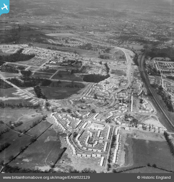
EAW022129 ENGLAND (1949). The South Oxhey Housing Estate under construction, South Oxhey, 1949
© Copyright OpenStreetMap contributors and licensed by the OpenStreetMap Foundation. 2026. Cartography is licensed as CC BY-SA.
Nearby Images (3)
EAW022129

EAW022133

EAW022131

Details
| Title | [EAW022129] The South Oxhey Housing Estate under construction, South Oxhey, 1949 |
| Reference | EAW022129 |
| Date | 14-April-1949 |
| Link | |
| Place name | SOUTH OXHEY |
| Parish | WATFORD RURAL |
| District | |
| Country | ENGLAND |
| Easting / Northing | 511613, 192832 |
| Longitude / Latitude | -0.38750016645143, 51.622756300648 |
| National Grid Reference | TQ116928 |
Pins

steve |
Thursday 24th of March 2016 04:26:49 PM | |
Kilmarnock Road was originally named as Ashdown Road on street maps and estate plans of the late 1940s. However, after some confusion with a road of similar name in Bushey (Ashdon Rd), this short road at the northern end of Caldwell Road was subsequently renamed. Comparatively few of the local residents refer to the old name as the change was implemented by 1951, as shown on the relevant page in the Kelly's Directory for 1952. Some of the older street atlases (Bartholomew's and Geographia) of the period still used the former version of Ashdown Road well into the following decade. David Reidy, an early inhabitant of Caldwell Road (1948-1969), can just recollect the original road name being used for a short period after the completion of this part of South Oxhey. |

John Swain |
Thursday 19th of May 2016 09:24:32 AM |
|
Steve |
Friday 26th of December 2014 07:06:55 AM | |
|
hoddy |
Tuesday 23rd of September 2014 02:28:02 PM | |
|
John Swain |
Saturday 21st of December 2013 11:03:22 AM | |
The opening sentence should read...Nanscot Wood..., as opposed to Nascot Wood, which is located in Watford, several miles to the north. |
John Swain |
Sunday 22nd of December 2013 04:37:57 PM |
|
John Swain |
Saturday 21st of December 2013 10:47:28 AM | |
|
John Swain |
Saturday 21st of December 2013 10:45:26 AM | |
|
John Swain |
Saturday 21st of December 2013 10:42:01 AM | |
|
John Swain |
Saturday 21st of December 2013 10:40:14 AM | |
|
John Swain |
Saturday 21st of December 2013 10:39:14 AM | |
|
John Swain |
Saturday 21st of December 2013 10:37:33 AM | |
|
John Swain |
Saturday 21st of December 2013 10:36:37 AM | |
|
John Swain |
Saturday 21st of December 2013 10:33:50 AM | |
|
John Swain |
Saturday 21st of December 2013 10:32:31 AM | |
|
John Swain |
Saturday 21st of December 2013 10:31:19 AM | |
|
John Swain |
Saturday 21st of December 2013 10:30:15 AM | |
|
John Swain |
Saturday 21st of December 2013 10:26:27 AM | |
|
John Swain |
Saturday 21st of December 2013 10:24:28 AM | |
 |
John Swain |
Saturday 21st of December 2013 10:20:28 AM |
|
John Swain |
Saturday 21st of December 2013 10:13:56 AM | |
|
John Swain |
Saturday 21st of December 2013 10:12:39 AM | |
|
John Swain |
Saturday 21st of December 2013 10:11:05 AM | |
|
John Swain |
Saturday 21st of December 2013 10:09:36 AM | |
|
John Swain |
Saturday 21st of December 2013 10:07:11 AM | |
|
John Swain |
Saturday 21st of December 2013 10:05:04 AM | |
|
John Swain |
Saturday 21st of December 2013 10:04:26 AM | |
|
John Swain |
Saturday 21st of December 2013 10:03:27 AM | |
The writer has been assisting local author, David Reidy, compile a detailed history of Clarendon School, from its inception in 1951 until the merger with neighbouring Hampden School 16 years later, to create a split-site comprehensive school, Sir James Altham, which closed in July 1989. The book should be available as a private publication later in 2016. |
John Swain |
Thursday 19th of May 2016 09:36:08 AM |
|
John Swain |
Saturday 21st of December 2013 10:01:04 AM | |
|
John Swain |
Saturday 21st of December 2013 09:53:32 AM | |
|
John Swain |
Saturday 21st of December 2013 09:35:14 AM | |
|
John Swain |
Saturday 21st of December 2013 09:34:18 AM | |
|
John Swain |
Saturday 21st of December 2013 09:31:59 AM | |
|
John Swain |
Saturday 21st of December 2013 09:30:19 AM | |
|
John Swain |
Saturday 21st of December 2013 09:23:47 AM |
User Comment Contributions
This shot of South Oxhey is taken in the south-east corner, looking north, and shows parts of the estate were already finished on the side adjacent to the main line railway. The left foreground and middle distance on this image would see further developments over the next three years, as the LCC housing estate eventually reached its target of 4,000 completed homes, providing accommodation for 17,000 inhabitants. The current population is in the order of 12,500, but this writer would estimate that upwards of 100,000 folk have resided in South Oxhey since its inception in 1946/47. Now there's a thought! |
John Swain |
Saturday 21st of December 2013 11:14:12 AM |
In this view of the emerging housing estate at South Oxhey, looking almost due north towards the nearby town of Watford (73,000), many of the original building units have been constructed in this south-east corner of the development. The main collector roads, Prestwick Road, Hayling Road, Oxhey Drive and Gosforth Lane have already been laid out, and they would form the basic structure for the numerous short cul-de-sacs. Building of the estate was mostly completed by 1952, with later additions in the form of a shopping centre, further schools, churches and social facilities. In his book,"Poor but Proud", David Reidy considers that the early years continued until 1970, by which time South Oxhey had the appearance of a permanent town, nestling on the lower slopes of the South Herts Plateau, largely out-of-view of local residents from Watford or Northwood! |
John Swain |
Saturday 21st of December 2013 09:15:26 AM |