
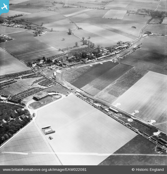
EAW022081 ENGLAND (1949). Westhampnett, Goodwood Motor Circuit on a race day, 1949. This image was marked by Aerofilms Ltd for photo editing.
© Copyright OpenStreetMap contributors and licensed by the OpenStreetMap Foundation. 2026. Cartography is licensed as CC BY-SA.
Nearby Images (12)
EAW022081

EAW022072

EAW022055

EAW022073

EAW022068

EAW022079

EAW022078

EAW022059

EAW022061

EAW022067

EAW022060

EAW022069

Details
| Title | [EAW022081] Westhampnett, Goodwood Motor Circuit on a race day, 1949. This image was marked by Aerofilms Ltd for photo editing. |
| Reference | EAW022081 |
| Date | 9-April-1949 |
| Link | |
| Place name | WESTHAMPNETT |
| Parish | WESTHAMPNETT |
| District | |
| Country | ENGLAND |
| Easting / Northing | 487764, 107769 |
| Longitude / Latitude | -0.75280959350354, 50.862203541825 |
| National Grid Reference | SU878078 |
Pins

Scorrybreck |
Sunday 16th of March 2014 09:42:23 PM | |
|
cptpies |
Wednesday 8th of January 2014 02:21:17 PM | |
|
cptpies |
Wednesday 8th of January 2014 02:18:25 PM |
User Comment Contributions

Goodwood. |
Scorrybreck |
Sunday 16th of March 2014 09:42:42 PM |
|
WWII Blast Shelter. Westhampnett. |
cptpies |
Wednesday 8th of January 2014 02:19:04 PM |