
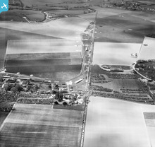
EAW022072 ENGLAND (1949). Westhampnett, Goodwood Motor Circuit on a race day, 1949

© Copyright OpenStreetMap contributors and licensed by the OpenStreetMap Foundation. 2026. Cartography is licensed as CC BY-SA.
Nearby Images (12)
EAW022072

EAW022055

EAW022061

EAW022081

EAW022073

EAW022067

EAW022068

EAW022059

EAW022060

EAW022066

EAW022054

EAW022069

Details
| Title | [EAW022072] Westhampnett, Goodwood Motor Circuit on a race day, 1949 |
| Reference | EAW022072 |
| Date | 9-April-1949 |
| Link | |
| Place name | WESTHAMPNETT |
| Parish | WESTHAMPNETT |
| District | |
| Country | ENGLAND |
| Easting / Northing | 487871, 107778 |
| Longitude / Latitude | -0.75128726932151, 50.862268208231 |
| National Grid Reference | SU879078 |
Pins

Scorrybreck |
Sunday 16th of March 2014 09:33:15 PM | |
|
cptpies |
Wednesday 8th of January 2014 02:24:00 PM |
User Comment Contributions
Goodwood. |
Scorrybreck |
Sunday 16th of March 2014 09:33:41 PM |
|
WWII LAA Gun Pit. RAF Westhampnett. |
cptpies |
Wednesday 8th of January 2014 02:24:33 PM |