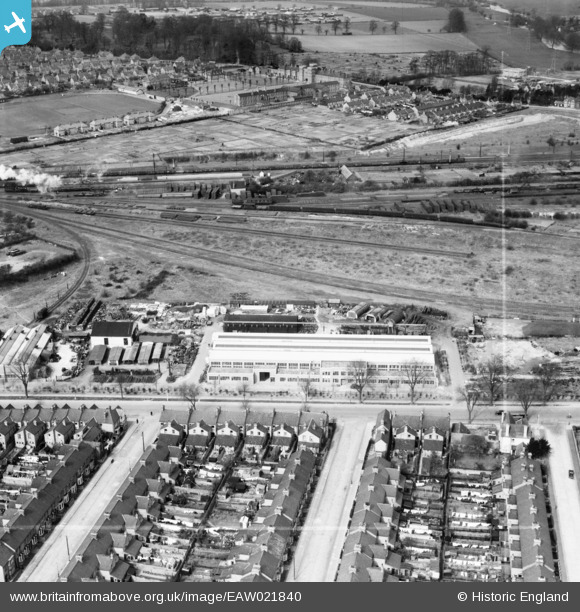
EAW021840 ENGLAND (1949). The W.H.A. Robertson & Co Ltd Lynton Engineering Works and environs, Bedford, 1949. This image was marked by Aerofilms Ltd for photo editing.
© Copyright OpenStreetMap contributors and licensed by the OpenStreetMap Foundation. 2026. Cartography is licensed as CC BY-SA.
Nearby Images (7)
Details
| Title | [EAW021840] The W.H.A. Robertson & Co Ltd Lynton Engineering Works and environs, Bedford, 1949. This image was marked by Aerofilms Ltd for photo editing. |
| Reference | EAW021840 |
| Date | 11-April-1949 |
| Link | |
| Place name | BEDFORD |
| Parish | |
| District | |
| Country | ENGLAND |
| Easting / Northing | 504541, 248281 |
| Longitude / Latitude | -0.47283695415928, 52.122533220887 |
| National Grid Reference | TL045483 |
Pins

melgibbs |
Sunday 12th of January 2014 03:43:32 PM | |

melgibbs |
Sunday 12th of January 2014 03:42:49 PM | |

melgibbs |
Sunday 12th of January 2014 03:41:25 PM | |

melgibbs |
Sunday 12th of January 2014 03:39:48 PM | |

melgibbs |
Sunday 12th of January 2014 03:39:20 PM | |

melgibbs |
Sunday 12th of January 2014 03:38:46 PM |


![[EAW021840] The W.H.A. Robertson & Co Ltd Lynton Engineering Works and environs, Bedford, 1949. This image was marked by Aerofilms Ltd for photo editing.](http://britainfromabove.org.uk/sites/all/libraries/aerofilms-images/public/100x100/EAW/021/EAW021840.jpg)
![[EAW021849] The W.H.A. Robertson & Co Ltd Lynton Engineering Works and environs, Bedford, 1949. This image was marked by Aerofilms Ltd for photo editing.](http://britainfromabove.org.uk/sites/all/libraries/aerofilms-images/public/100x100/EAW/021/EAW021849.jpg)
![[EAW021848] The W.H.A. Robertson & Co Ltd Lynton Engineering Works and environs, Bedford, 1949. This image was marked by Aerofilms Ltd for photo editing.](http://britainfromabove.org.uk/sites/all/libraries/aerofilms-images/public/100x100/EAW/021/EAW021848.jpg)
![[EAW021846] The W.H.A. Robertson & Co Ltd Lynton Engineering Works and environs, Bedford, 1949. This image was marked by Aerofilms Ltd for photo editing.](http://britainfromabove.org.uk/sites/all/libraries/aerofilms-images/public/100x100/EAW/021/EAW021846.jpg)
![[EAW021841] The W.H.A. Robertson & Co Ltd Lynton Engineering Works and environs, Bedford, 1949. This image was marked by Aerofilms Ltd for photo editing.](http://britainfromabove.org.uk/sites/all/libraries/aerofilms-images/public/100x100/EAW/021/EAW021841.jpg)
![[EAW021842] The W.H.A. Robertson & Co Ltd Lynton Engineering Works and environs, Bedford, from the east, 1949. This image was marked by Aerofilms Ltd for photo editing.](http://britainfromabove.org.uk/sites/all/libraries/aerofilms-images/public/100x100/EAW/021/EAW021842.jpg)
![[EAW021847] Ampthill Road, the W.H.A. Robertson & Co Ltd Lynton Engineering Works and environs, Bedford, 1949. This image was marked by Aerofilms Ltd for photo editing.](http://britainfromabove.org.uk/sites/all/libraries/aerofilms-images/public/100x100/EAW/021/EAW021847.jpg)