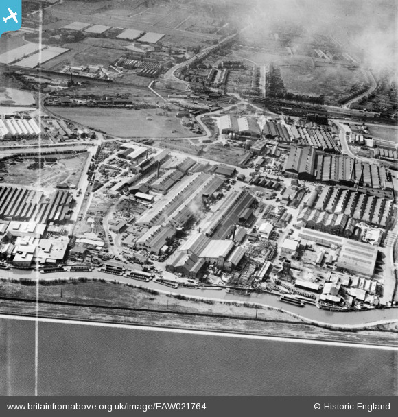
EAW021764 ENGLAND (1949). The Enfield Cables Ltd Works and the surrounding industrial area, Brimsdown, 1949. This image was marked by Aerofilms Ltd for photo editing.
© Copyright OpenStreetMap contributors and licensed by the OpenStreetMap Foundation. 2026. Cartography is licensed as CC BY-SA.
Nearby Images (41)
Details
| Title | [EAW021764] The Enfield Cables Ltd Works and the surrounding industrial area, Brimsdown, 1949. This image was marked by Aerofilms Ltd for photo editing. |
| Reference | EAW021764 |
| Date | 1-April-1949 |
| Link | |
| Place name | BRIMSDOWN |
| Parish | |
| District | |
| Country | ENGLAND |
| Easting / Northing | 536826, 197004 |
| Longitude / Latitude | -0.021822718877532, 51.65468410736 |
| National Grid Reference | TQ368970 |
Pins
Be the first to add a comment to this image!


![[EAW021764] The Enfield Cables Ltd Works and the surrounding industrial area, Brimsdown, 1949. This image was marked by Aerofilms Ltd for photo editing.](http://britainfromabove.org.uk/sites/all/libraries/aerofilms-images/public/100x100/EAW/021/EAW021764.jpg)
![[EAW021773] The Enfield Cables Ltd Cable Works and environs, Brimsdown, 1949. This image was marked by Aerofilms Ltd for photo editing.](http://britainfromabove.org.uk/sites/all/libraries/aerofilms-images/public/100x100/EAW/021/EAW021773.jpg)
![[EPW044233] Enfield Cable Co Works and surrounding industry, Brimsdown, 1934](http://britainfromabove.org.uk/sites/all/libraries/aerofilms-images/public/100x100/EPW/044/EPW044233.jpg)
![[EPW008046] Brimsdown Lead Works and the Rolling Mills, Enfield, 1922](http://britainfromabove.org.uk/sites/all/libraries/aerofilms-images/public/100x100/EPW/008/EPW008046.jpg)
![[EAW000008] River Lea Navigation, Brimsdown Power Station and environs, Brimsdown, 1946](http://britainfromabove.org.uk/sites/all/libraries/aerofilms-images/public/100x100/EAW/000/EAW000008.jpg)
![[EAW021772] The Enfield Cables Ltd Cable Works and environs, Brimsdown, 1949. This image was marked by Aerofilms Ltd for photo editing.](http://britainfromabove.org.uk/sites/all/libraries/aerofilms-images/public/100x100/EAW/021/EAW021772.jpg)
![[EAW021766] The Enfield Cables Ltd Works and the surrounding industrial area, Brimsdown, 1949. This image was marked by Aerofilms Ltd for photo editing.](http://britainfromabove.org.uk/sites/all/libraries/aerofilms-images/public/100x100/EAW/021/EAW021766.jpg)
![[EAW021765] The Enfield Cables Ltd Works and the surrounding industrial area, Brimsdown, 1949. This image was marked by Aerofilms Ltd for photo editing.](http://britainfromabove.org.uk/sites/all/libraries/aerofilms-images/public/100x100/EAW/021/EAW021765.jpg)
![[EAW005271] The Brimsdown Industrial Estate and environs, Brimsdown, 1947. This image was marked by Aerofilms Ltd for photo editing.](http://britainfromabove.org.uk/sites/all/libraries/aerofilms-images/public/100x100/EAW/005/EAW005271.jpg)
![[EAW021761] The Enfield Cables Ltd Works and the surrounding industrial area, Brimsdown, 1949. This image was marked by Aerofilms Ltd for photo editing.](http://britainfromabove.org.uk/sites/all/libraries/aerofilms-images/public/100x100/EAW/021/EAW021761.jpg)
![[EAW021763] The Enfield Cables Ltd Works and the surrounding industrial area, Brimsdown, 1949. This image was marked by Aerofilms Ltd for photo editing.](http://britainfromabove.org.uk/sites/all/libraries/aerofilms-images/public/100x100/EAW/021/EAW021763.jpg)
![[EAW021774] The Enfield Cables Ltd Cable Works and environs, Brimsdown, 1949. This image was marked by Aerofilms Ltd for photo editing.](http://britainfromabove.org.uk/sites/all/libraries/aerofilms-images/public/100x100/EAW/021/EAW021774.jpg)
![[EPW008043] Brimsdown Lead Works, Enfield, 1922](http://britainfromabove.org.uk/sites/all/libraries/aerofilms-images/public/100x100/EPW/008/EPW008043.jpg)
![[EAW021762] The Enfield Cables Ltd Works and the surrounding industrial area, Brimsdown, 1949. This image was marked by Aerofilms Ltd for photo editing.](http://britainfromabove.org.uk/sites/all/libraries/aerofilms-images/public/100x100/EAW/021/EAW021762.jpg)
![[EAW004479] Brimsdown Industrial Estate and environs, Brimsdown, from the south, 1947](http://britainfromabove.org.uk/sites/all/libraries/aerofilms-images/public/100x100/EAW/004/EAW004479.jpg)
![[EPW044228] Enfield Cable Co Works and the Enfield Rolling Mills, Brimsdown, 1934](http://britainfromabove.org.uk/sites/all/libraries/aerofilms-images/public/100x100/EPW/044/EPW044228.jpg)
![[EPW008045] Brimsdown Lead Works, Enfield, 1922](http://britainfromabove.org.uk/sites/all/libraries/aerofilms-images/public/100x100/EPW/008/EPW008045.jpg)
![[EPW008044] Brimsdown Lead Works, Enfield, 1922](http://britainfromabove.org.uk/sites/all/libraries/aerofilms-images/public/100x100/EPW/008/EPW008044.jpg)
![[EPW044232] Enfield Cable Co Works and surrounding industry, Brimsdown, 1934](http://britainfromabove.org.uk/sites/all/libraries/aerofilms-images/public/100x100/EPW/044/EPW044232.jpg)
![[EPW044231] Enfield Rolling Mills and the Enfield Cable Co Works, Brimsdown, 1934](http://britainfromabove.org.uk/sites/all/libraries/aerofilms-images/public/100x100/EPW/044/EPW044231.jpg)
![[EPW025596] The Enfield Cable Works, Brimsdown, 1929. This image has been produced from a damaged negative.](http://britainfromabove.org.uk/sites/all/libraries/aerofilms-images/public/100x100/EPW/025/EPW025596.jpg)
![[EPW046482] The Ruberoid Co Works, the Enfield Cable Works and environs, Brimsdown, 1935](http://britainfromabove.org.uk/sites/all/libraries/aerofilms-images/public/100x100/EPW/046/EPW046482.jpg)
![[EPW017346] The Enfield Cable Works, Brimsdown, 1926](http://britainfromabove.org.uk/sites/all/libraries/aerofilms-images/public/100x100/EPW/017/EPW017346.jpg)
![[EPW017345] The Enfield Cable Works, Brimsdown, 1926](http://britainfromabove.org.uk/sites/all/libraries/aerofilms-images/public/100x100/EPW/017/EPW017345.jpg)
![[EPW044230] Enfield Cable Co Works and surrounding industry, Brimsdown, 1934](http://britainfromabove.org.uk/sites/all/libraries/aerofilms-images/public/100x100/EPW/044/EPW044230.jpg)
![[EPW017350] The Enfield Cable Works, Brimsdown, 1926. This image has been produced from a print.](http://britainfromabove.org.uk/sites/all/libraries/aerofilms-images/public/100x100/EPW/017/EPW017350.jpg)
![[EPW044229] Enfield Cable Co Works and surrounding industry, Brimsdown, 1934](http://britainfromabove.org.uk/sites/all/libraries/aerofilms-images/public/100x100/EPW/044/EPW044229.jpg)
![[EAW005270] The Brimsdown Industrial Estate and environs, Brimsdown, 1947](http://britainfromabove.org.uk/sites/all/libraries/aerofilms-images/public/100x100/EAW/005/EAW005270.jpg)
![[EAW004480] Brimsdown Industrial Estate, King George's Reservoir and environs, Brimsdown, from the south, 1947](http://britainfromabove.org.uk/sites/all/libraries/aerofilms-images/public/100x100/EAW/004/EAW004480.jpg)
![[EPW008034] The Enfield Cable Works, Enfield, 1922](http://britainfromabove.org.uk/sites/all/libraries/aerofilms-images/public/100x100/EPW/008/EPW008034.jpg)
![[EPW025595] The Enfield Cable Works, Brimsdown, 1929. This image has been produced from a damaged negative.](http://britainfromabove.org.uk/sites/all/libraries/aerofilms-images/public/100x100/EPW/025/EPW025595.jpg)
![[EPW008032] The Enfield Cable Works, Enfield, 1922](http://britainfromabove.org.uk/sites/all/libraries/aerofilms-images/public/100x100/EPW/008/EPW008032.jpg)
![[EPW046484] The Ruberoid Co Works on the River Lea and environs, Brimsdown, 1935](http://britainfromabove.org.uk/sites/all/libraries/aerofilms-images/public/100x100/EPW/046/EPW046484.jpg)
![[EPW017353] The Enfield Cable Works, Brimsdown, 1926](http://britainfromabove.org.uk/sites/all/libraries/aerofilms-images/public/100x100/EPW/017/EPW017353.jpg)
![[EPW028513] The Enfield Cable Works, Enfield, 1929](http://britainfromabove.org.uk/sites/all/libraries/aerofilms-images/public/100x100/EPW/028/EPW028513.jpg)
![[EPW008031] The Enfield Cable Works, Enfield, 1922](http://britainfromabove.org.uk/sites/all/libraries/aerofilms-images/public/100x100/EPW/008/EPW008031.jpg)
![[EPW017349] The Enfield Cable Works, Brimsdown, 1926](http://britainfromabove.org.uk/sites/all/libraries/aerofilms-images/public/100x100/EPW/017/EPW017349.jpg)
![[EPW008036] The Enfield Cable Works, Enfield, 1922](http://britainfromabove.org.uk/sites/all/libraries/aerofilms-images/public/100x100/EPW/008/EPW008036.jpg)
![[EPW017347] The Enfield Cable Works, Brimsdown, 1926](http://britainfromabove.org.uk/sites/all/libraries/aerofilms-images/public/100x100/EPW/017/EPW017347.jpg)
![[EAW005269] The Brimsdown Industrial Estate and environs, Brimsdown, 1947](http://britainfromabove.org.uk/sites/all/libraries/aerofilms-images/public/100x100/EAW/005/EAW005269.jpg)
![[EPW017354] The Enfield Cable Works, Brimsdown, 1926](http://britainfromabove.org.uk/sites/all/libraries/aerofilms-images/public/100x100/EPW/017/EPW017354.jpg)