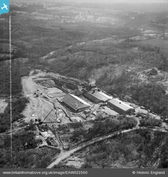
EAW021560 ENGLAND (1949). Nutbourne Brickworks, Hambledon, 1949. This image was marked by Aerofilms Ltd for photo editing.
© Copyright OpenStreetMap contributors and licensed by the OpenStreetMap Foundation. 2024. Cartography is licensed as CC BY-SA.
Nearby Images (9)
Details
| Title | [EAW021560] Nutbourne Brickworks, Hambledon, 1949. This image was marked by Aerofilms Ltd for photo editing. |
| Reference | EAW021560 |
| Date | 21-March-1949 |
| Link | |
| Place name | HAMBLEDON |
| Parish | HAMBLEDON |
| District | |
| Country | ENGLAND |
| Easting / Northing | 497316, 137507 |
| Longitude / Latitude | -0.60913823838811, 51.128038286249 |
| National Grid Reference | SU973375 |
Pins
 Dan Gregory |
Tuesday 3rd of June 2014 12:48:03 AM | |
 Dan Gregory |
Tuesday 3rd of June 2014 12:47:27 AM | |
 Dan Gregory |
Tuesday 3rd of June 2014 12:45:36 AM | |
 Dan Gregory |
Tuesday 3rd of June 2014 12:41:42 AM | |
 Dan Gregory |
Tuesday 3rd of June 2014 12:40:46 AM | |
 Dan Gregory |
Tuesday 3rd of June 2014 12:40:23 AM | |
 Dan Gregory |
Tuesday 3rd of June 2014 12:40:00 AM |


![[EAW021560] Nutbourne Brickworks, Hambledon, 1949. This image was marked by Aerofilms Ltd for photo editing.](http://britainfromabove.org.uk/sites/all/libraries/aerofilms-images/public/100x100/EAW/021/EAW021560.jpg)
![[EAW021564] Nutbourne Brickworks, Hambledon, from the north-east, 1949. This image has been produced from a damaged negative.](http://britainfromabove.org.uk/sites/all/libraries/aerofilms-images/public/100x100/EAW/021/EAW021564.jpg)
![[EAW021559] Nutbourne Brickworks, Hambledon, 1949](http://britainfromabove.org.uk/sites/all/libraries/aerofilms-images/public/100x100/EAW/021/EAW021559.jpg)
![[EAW021561] Nutbourne Brickworks, Hambledon, 1949. This image was marked by Aerofilms Ltd for photo editing.](http://britainfromabove.org.uk/sites/all/libraries/aerofilms-images/public/100x100/EAW/021/EAW021561.jpg)
![[EAW021562] Nutbourne Brickworks, Hambledon, 1949. This image was marked by Aerofilms Ltd for photo editing.](http://britainfromabove.org.uk/sites/all/libraries/aerofilms-images/public/100x100/EAW/021/EAW021562.jpg)
![[EAW021567] Nutbourne Brickworks, Hambledon, 1949. This image was marked by Aerofilms Ltd for photo editing.](http://britainfromabove.org.uk/sites/all/libraries/aerofilms-images/public/100x100/EAW/021/EAW021567.jpg)
![[EAW021565] Nutbourne Brickworks, Hambledon, 1949. This image has been produced from a damaged negative.](http://britainfromabove.org.uk/sites/all/libraries/aerofilms-images/public/100x100/EAW/021/EAW021565.jpg)
![[EAW021563] Nutbourne Brickworks, Hambledon, 1949. This image has been produced from a damaged negative.](http://britainfromabove.org.uk/sites/all/libraries/aerofilms-images/public/100x100/EAW/021/EAW021563.jpg)
![[EAW021566] Nutbourne Brickworks, Hambledon, 1949. This image has been produced from a damaged negative.](http://britainfromabove.org.uk/sites/all/libraries/aerofilms-images/public/100x100/EAW/021/EAW021566.jpg)