
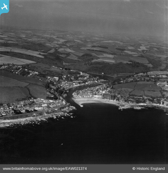
EAW021374 ENGLAND (1949). Looe Bay, the harbour and the town, Looe, from the south-east, 1949. This image has been produced from a print.
© Copyright OpenStreetMap contributors and licensed by the OpenStreetMap Foundation. 2026. Cartography is licensed as CC BY-SA.
Nearby Images (18)
EAW021374

EAW051358

EAW040787

EAW040788

EAW040786

EAW040785

EAW040790

EAW040784

EAW020275

EAW040789

EAW020248

EAW020246

EAW020247

EAW020249

EPW033109

EAW020250

EPW033112

EAW051360

Details
| Title | [EAW021374] Looe Bay, the harbour and the town, Looe, from the south-east, 1949. This image has been produced from a print. |
| Reference | EAW021374 |
| Date | 11-March-1949 |
| Link | |
| Place name | LOOE |
| Parish | LOOE |
| District | |
| Country | ENGLAND |
| Easting / Northing | 225774, 52963 |
| Longitude / Latitude | -4.4492512129716, 50.350153984568 |
| National Grid Reference | SX258530 |
Pins

Matt Aldred edob.mattaldred.com |
Tuesday 9th of March 2021 03:47:46 PM | |
|
Matt Aldred edob.mattaldred.com |
Tuesday 9th of March 2021 03:47:33 PM | |
|
Matt Aldred edob.mattaldred.com |
Tuesday 9th of March 2021 03:47:18 PM | |
|
Matt Aldred edob.mattaldred.com |
Tuesday 9th of March 2021 03:46:53 PM | |

redmist |
Wednesday 16th of December 2020 10:56:06 AM | |
|
redmist |
Tuesday 15th of December 2020 03:56:28 PM | |
|
Alec K |
Sunday 29th of November 2020 02:43:15 PM | |
|
CornwallPhil |
Saturday 6th of September 2014 10:22:40 PM | |
|
CornwallPhil |
Saturday 6th of September 2014 10:21:09 PM | |
|
CornwallPhil |
Saturday 6th of September 2014 10:17:15 PM | |
|
CornwallPhil |
Saturday 6th of September 2014 10:15:53 PM | |
|
CornwallPhil |
Saturday 6th of September 2014 10:13:03 PM | |
|
CornwallPhil |
Saturday 6th of September 2014 10:11:57 PM | |
|
CornwallPhil |
Saturday 6th of September 2014 10:11:03 PM | |
|
CornwallPhil |
Saturday 6th of September 2014 10:09:09 PM | |
|
CornwallPhil |
Saturday 6th of September 2014 10:07:49 PM | |
|
CornwallPhil |
Saturday 6th of September 2014 10:07:00 PM | |
|
CornwallPhil |
Saturday 6th of September 2014 10:06:25 PM | |
|
CornwallPhil |
Saturday 6th of September 2014 10:04:02 PM |
User Comment Contributions

Various WW2 structures |
CornwallPhil |
Saturday 6th of September 2014 10:23:31 PM |