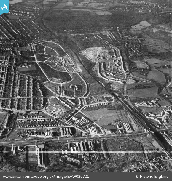
EAW020721 ENGLAND (1948). New housing development around Tillingbourne Green and Ravensbury Road, Poverest, 1948. This image was marked by Aerofilms Ltd for photo editing.
    © Copyright OpenStreetMap contributors and licensed by the OpenStreetMap Foundation. 2025. Cartography is licensed as CC BY-SA.
  
Details
| Title | [EAW020721] New housing development around Tillingbourne Green and Ravensbury Road, Poverest, 1948. This image was marked by Aerofilms Ltd for photo editing. | 
| Reference | EAW020721 | 
| Date | 24-December-1948 | 
| Link | |
| Place name | POVEREST | 
| Parish | |
| District | |
| Country | ENGLAND | 
| Easting / Northing | 546451, 168175 | 
| Longitude / Latitude | 0.1052475556847, 51.393190842505 | 
| National Grid Reference | TQ465682 | 
Pins
|  Likely WW2 Bomb Crater |   Matt Aldred edob.mattaldred.com | Tuesday 8th of April 2025 01:22:33 PM | 
|  The Blue Lagoon open air swimming pool.  Opening in the early 1930s, the pool had become derelict by the time of the photo.  The site is now named Lagoon Road and contains  a number of industrial units. |   garyb | Monday 7th of July 2014 10:52:01 PM | 
|  The Bridge House Public House located  on the corner of Cray Valley Road and Cray Avenue (A224).The site was later to become Comet electrical store followed by T-K Maxx. |   garyb | Monday 7th of July 2014 10:44:53 PM | 
|  St Mary Cray Station |   Gone2Kent | Friday 31st of January 2014 10:45:57 PM | 
 
             
  ![[EAW020721] New housing development around Tillingbourne Green and Ravensbury Road, Poverest, 1948. This image was marked by Aerofilms Ltd for photo editing.](http://britainfromabove.org.uk/sites/all/libraries/aerofilms-images/public/100x100/EAW/020/EAW020721.jpg) 
  
                                          ![[EAW020742] Construction of housing around 88 Ravensbury Road, St Paul's Cray, 1948](http://britainfromabove.org.uk/sites/all/libraries/aerofilms-images/public/100x100/EAW/020/EAW020742.jpg) 
 ![[EAW020741] Constuction of 17-23 Clarendon Green, St Paul's Cray, 1948](http://britainfromabove.org.uk/sites/all/libraries/aerofilms-images/public/100x100/EAW/020/EAW020741.jpg) 
 ![[EAW020718] Robin Hood Green and new housing development around Tillingbourne Green and Ravensbury Road, Poverest, 1948](http://britainfromabove.org.uk/sites/all/libraries/aerofilms-images/public/100x100/EAW/020/EAW020718.jpg)