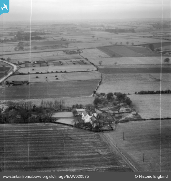
EAW020575 ENGLAND (1948). The White House, Stockton-on-Tees, from the east, 1948. This image was marked by Aerofilms Ltd for photo editing.
© Copyright OpenStreetMap contributors and licensed by the OpenStreetMap Foundation. 2026. Cartography is licensed as CC BY-SA.
Nearby Images (15)
Details
| Title | [EAW020575] The White House, Stockton-on-Tees, from the east, 1948. This image was marked by Aerofilms Ltd for photo editing. |
| Reference | EAW020575 |
| Date | 17-November-1948 |
| Link | |
| Place name | STOCKTON-ON-TEES |
| Parish | |
| District | |
| Country | ENGLAND |
| Easting / Northing | 442688, 519933 |
| Longitude / Latitude | -1.3396023671, 54.572686847905 |
| National Grid Reference | NZ427199 |
Pins

J May |
Thursday 14th of January 2016 01:53:45 PM | |

J May |
Tuesday 26th of August 2014 07:19:59 PM | |

J May |
Wednesday 6th of August 2014 02:09:17 PM | |

J May |
Monday 6th of January 2014 07:45:32 PM |
User Comment Contributions
Boldon House was the location of a "Y station", a listening post operated by the Royal Navy. "At the start of the war, the navy had only one wireless station for intercepting messages, at Stockton" Boldon House is still standing, but is now in the middle of Elm Tree housing estate. http://www.bing.com/maps/?v=2&cp=t2vw8ngwmq1f&lvl=20&dir=90&sty=b&form=LMLTCC |

J May |
Tuesday 19th of August 2014 10:26:16 AM |
This is fascinating. Do you have more information about when the Y Station was being used? |
Lynda Tubbs |
Tuesday 29th of July 2014 11:49:35 AM |
No firm dates but reported as the only available facility at the out break of war in 1914. It's roles included tracking u-boat, surface ship and zeppelin movements. I found a copy of an article from Fortress magazine in a local library that described the station in detail and the work being carried out. |

J May |
Thursday 31st of July 2014 10:56:39 PM |
I see the house is still standing but I wonder if any of the other buildings - the powerhouse and battery room - are still there. Can they be identified on the photograph? I found a reference to the magazine article here: http://www.airfieldinformationexchange.org/community/showthread.php?7478-WWI-Y-station-at-Stockton |
Lynda Tubbs |
Tuesday 5th of August 2014 01:57:24 PM |
There are two remaining buildings, the main brick building was the operations block (now a house), and the other brick building was the power/battery house (not sure what it is now, presumably a store). The magazine article (Fortress, Issue No.8, Feb 1991, ISBN 1855120135) mentioned a wooden structure reported to of been constructed from a previous "L" shaped building on the site, but this also seems to be missing from recent pictures of the site. There was also mention that some of the anchor points for the masts were still in place and a small section of the original boundary fence was still in place (and still is), the fence post foundations have Navy anchor symbols on them. I will take a look next time I pass, which I do nearly every week. |

J May |
Wednesday 6th of August 2014 02:07:36 PM |
Thank you for adding this 'local knowledge' which helps us to understand what is already known. It's interesting that there might still be some evidence to be seen - any chance of a photo? |
Lynda Tubbs |
Tuesday 19th of August 2014 10:26:16 AM |


![[EAW020575] The White House, Stockton-on-Tees, from the east, 1948. This image was marked by Aerofilms Ltd for photo editing.](http://britainfromabove.org.uk/sites/all/libraries/aerofilms-images/public/100x100/EAW/020/EAW020575.jpg)
![[EAW020576] The White House, Stockton-on-Tees, from the east, 1948](http://britainfromabove.org.uk/sites/all/libraries/aerofilms-images/public/100x100/EAW/020/EAW020576.jpg)
![[EAW023512] White House, White House Farm and the Daylight Bakery, Stockton-on-Tees, from the south-west, 1949. This image was marked by Aerofilms Ltd for photo editing.](http://britainfromabove.org.uk/sites/all/libraries/aerofilms-images/public/100x100/EAW/023/EAW023512.jpg)
![[EAW020574] White House Farm, Stockton-on-Tees, 1948. This image was marked by Aerofilms Ltd for photo editing.](http://britainfromabove.org.uk/sites/all/libraries/aerofilms-images/public/100x100/EAW/020/EAW020574.jpg)
![[EAW020579] Ralph Spark & Sons Ltd Daylight Bakery on Bishopton Avenue and surrounding countryside, Stockton-on-Tees, from the east, 1948. This image was marked by Aerofilms Ltd for photo editing.](http://britainfromabove.org.uk/sites/all/libraries/aerofilms-images/public/100x100/EAW/020/EAW020579.jpg)
![[EAW016860] Ralph Spark & Sons Ltd Daylight Bakery on Bishopton Avenue and construction of housing around Farndale Green, Stockton-on-Tees, 1948. This image was marked by Aerofilms Ltd for photo editing.](http://britainfromabove.org.uk/sites/all/libraries/aerofilms-images/public/100x100/EAW/016/EAW016860.jpg)
![[EAW023515] Stockton Grange looking towards the Daylight Bakery, Stockton-on-Tees, from the south, 1949. This image was marked by Aerofilms Ltd for photo editing.](http://britainfromabove.org.uk/sites/all/libraries/aerofilms-images/public/100x100/EAW/023/EAW023515.jpg)
![[EAW020578] Ralph Spark & Sons Ltd Daylight Bakery on Bishopton Avenue and surrounding countryside, Stockton-on-Tees, from the south-east, 1948. This image was marked by Aerofilms Ltd for photo editing.](http://britainfromabove.org.uk/sites/all/libraries/aerofilms-images/public/100x100/EAW/020/EAW020578.jpg)
![[EAW020572] White House Farm, Stockton-on-Tees, from the east, 1948](http://britainfromabove.org.uk/sites/all/libraries/aerofilms-images/public/100x100/EAW/020/EAW020572.jpg)
![[EAW016861] Ralph Spark & Sons Ltd Daylight Bakery on Bishopton Avenue and construction of housing around Farndale Green, Stockton-on-Tees, 1948](http://britainfromabove.org.uk/sites/all/libraries/aerofilms-images/public/100x100/EAW/016/EAW016861.jpg)
![[EAW016862] Ralph Spark & Sons Ltd Daylight Bakery on Bishopton Avenue, construction of housing around Farndale Green and surrounding countryside, Stockton-on-Tees, 1948. This image was marked by Aerofilms Ltd for photo editing.](http://britainfromabove.org.uk/sites/all/libraries/aerofilms-images/public/100x100/EAW/016/EAW016862.jpg)
![[EAW023510] The Daylight Bakery, Stockton-on-Tees, 1949. This image was marked by Aerofilms Ltd for photo editing.](http://britainfromabove.org.uk/sites/all/libraries/aerofilms-images/public/100x100/EAW/023/EAW023510.jpg)
![[EAW020583] Ralph Spark & Sons Ltd Daylight Bakery on Bishopton Avenue, construction of housing around Glaisdale Avenue and surrounding countryside, Stockton-on-Tees, from the east, 1948](http://britainfromabove.org.uk/sites/all/libraries/aerofilms-images/public/100x100/EAW/020/EAW020583.jpg)
![[EAW016858] Ralph Spark & Sons Ltd Daylight Bakery on Bishopton Avenue, Stockton-on-Tees, from the south, 1948. This image has been produced from a damaged negative.](http://britainfromabove.org.uk/sites/all/libraries/aerofilms-images/public/100x100/EAW/016/EAW016858.jpg)
![[EAW020573] Ralph Spark & Sons Ltd Daylight Bakery on Bishopton Avenue, Stockton-on-Tees, 1948](http://britainfromabove.org.uk/sites/all/libraries/aerofilms-images/public/100x100/EAW/020/EAW020573.jpg)

