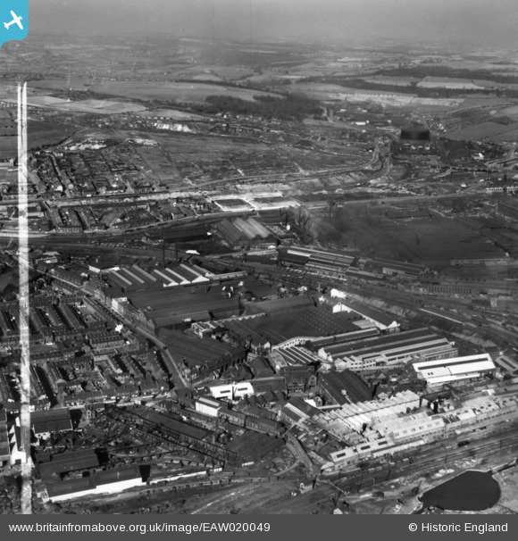
EAW020049 ENGLAND (1948). The Staybrite Steel Works and environs, Tinsley, from the south-east, 1948. This image has been produced from a print marked by Aerofilms Ltd for photo editing.
© Copyright OpenStreetMap contributors and licensed by the OpenStreetMap Foundation. 2026. Cartography is licensed as CC BY-SA.
Nearby Images (15)
Details
| Title | [EAW020049] The Staybrite Steel Works and environs, Tinsley, from the south-east, 1948. This image has been produced from a print marked by Aerofilms Ltd for photo editing. |
| Reference | EAW020049 |
| Date | 19-October-1948 |
| Link | |
| Place name | TINSLEY |
| Parish | |
| District | |
| Country | ENGLAND |
| Easting / Northing | 439188, 390237 |
| Longitude / Latitude | -1.4104450026062, 53.407231939223 |
| National Grid Reference | SK392902 |
Pins

Duck648 |
Tuesday 19th of April 2022 01:04:41 PM |


![[EAW020049] The Staybrite Steel Works and environs, Tinsley, from the south-east, 1948. This image has been produced from a print marked by Aerofilms Ltd for photo editing.](http://britainfromabove.org.uk/sites/all/libraries/aerofilms-images/public/100x100/EAW/020/EAW020049.jpg)
![[EAW020044] The Staybrite Steel Works, Tinsley Locks and environs, Tinsley, 1948. This image has been produced from a print marked by Aerofilms Ltd for photo editing.](http://britainfromabove.org.uk/sites/all/libraries/aerofilms-images/public/100x100/EAW/020/EAW020044.jpg)
![[EPW041542] The Staybrite Steel Works and environs, Tinsley, 1933](http://britainfromabove.org.uk/sites/all/libraries/aerofilms-images/public/100x100/EPW/041/EPW041542.jpg)
![[EAW018761] The Staybrite Steel Works on Weedon Street and environs, Tinsley, 1948. This image was marked by Aerofilms Ltd for photo editing.](http://britainfromabove.org.uk/sites/all/libraries/aerofilms-images/public/100x100/EAW/018/EAW018761.jpg)
![[EAW020043] The Staybrite Steel Works and environs, Tinsley, 1948. This image has been produced from a print marked by Aerofilms Ltd for photo editing.](http://britainfromabove.org.uk/sites/all/libraries/aerofilms-images/public/100x100/EAW/020/EAW020043.jpg)
![[EAW020042] The Staybrite Steel Works and environs, Tinsley, 1948. This image has been produced from a print marked by Aerofilms Ltd for photo editing.](http://britainfromabove.org.uk/sites/all/libraries/aerofilms-images/public/100x100/EAW/020/EAW020042.jpg)
![[EPW041545] The Staybrite Steel Works, Tinsley, 1933](http://britainfromabove.org.uk/sites/all/libraries/aerofilms-images/public/100x100/EPW/041/EPW041545.jpg)
![[EAW020050] The Staybrite Steel Works and environs, Tinsley, 1948. This image has been produced from a print marked by Aerofilms Ltd for photo editing.](http://britainfromabove.org.uk/sites/all/libraries/aerofilms-images/public/100x100/EAW/020/EAW020050.jpg)
![[EPW041541] The Staybrite Steel Works, Tinsley, 1933](http://britainfromabove.org.uk/sites/all/libraries/aerofilms-images/public/100x100/EPW/041/EPW041541.jpg)
![[EAW020052] The Staybrite Steel Works and environs, Tinsley, 1948. This image has been produced from a print marked by Aerofilms Ltd for photo editing.](http://britainfromabove.org.uk/sites/all/libraries/aerofilms-images/public/100x100/EAW/020/EAW020052.jpg)
![[EAW018763] The Staybrite Steel Works on Weedon Street and environs, Tinsley, 1948. This image was marked by Aerofilms Ltd for photo editing.](http://britainfromabove.org.uk/sites/all/libraries/aerofilms-images/public/100x100/EAW/018/EAW018763.jpg)
![[EAW020051] The Staybrite Steel Works and environs, Tinsley, 1948. This image has been produced from a print marked by Aerofilms Ltd for photo editing.](http://britainfromabove.org.uk/sites/all/libraries/aerofilms-images/public/100x100/EAW/020/EAW020051.jpg)
![[EPW041543] The Staybrite Steel Works and the Sheffield Corporation Tram Depot, Tinsley, 1933](http://britainfromabove.org.uk/sites/all/libraries/aerofilms-images/public/100x100/EPW/041/EPW041543.jpg)
![[EAW020045] The Staybrite Steel Works and environs, Tinsley, 1948. This image has been produced from a print marked by Aerofilms Ltd for photo editing.](http://britainfromabove.org.uk/sites/all/libraries/aerofilms-images/public/100x100/EAW/020/EAW020045.jpg)
![[EPW041540] The Staybrite Steel Works and the Imperial Steel Works, Tinsley, 1933](http://britainfromabove.org.uk/sites/all/libraries/aerofilms-images/public/100x100/EPW/041/EPW041540.jpg)