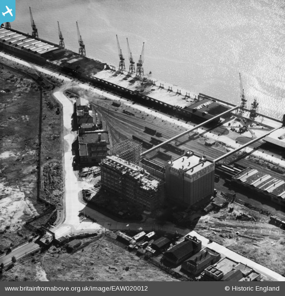
EAW020012 ENGLAND (1948). Construction work at J. Rank Ltd Solent Flour Mills, Southampton, 1948
© Copyright OpenStreetMap contributors and licensed by the OpenStreetMap Foundation. 2026. Cartography is licensed as CC BY-SA.
Nearby Images (39)
Details
| Title | [EAW020012] Construction work at J. Rank Ltd Solent Flour Mills, Southampton, 1948 |
| Reference | EAW020012 |
| Date | 19-October-1948 |
| Link | |
| Place name | SOUTHAMPTON |
| Parish | |
| District | |
| Country | ENGLAND |
| Easting / Northing | 441029, 111629 |
| Longitude / Latitude | -1.4164568380624, 50.902123596753 |
| National Grid Reference | SU410116 |
Pins
Be the first to add a comment to this image!


![[EAW020012] Construction work at J. Rank Ltd Solent Flour Mills, Southampton, 1948](http://britainfromabove.org.uk/sites/all/libraries/aerofilms-images/public/100x100/EAW/020/EAW020012.jpg)
![[EAW035625] Joseph Rank Ltd Solent Flour Mills, Southampton, 1951. This image has been produced from a print marked by Aerofilms Ltd for photo editing.](http://britainfromabove.org.uk/sites/all/libraries/aerofilms-images/public/100x100/EAW/035/EAW035625.jpg)
![[EAW035620] Joseph Rank Ltd Solent Flour Mills, Southampton, 1951. This image has been produced from a print marked by Aerofilms Ltd for photo editing.](http://britainfromabove.org.uk/sites/all/libraries/aerofilms-images/public/100x100/EAW/035/EAW035620.jpg)
![[EAW035622] Joseph Rank Ltd Solent Flour Mills, Southampton, 1951. This image has been produced from a print marked by Aerofilms Ltd for photo editing.](http://britainfromabove.org.uk/sites/all/libraries/aerofilms-images/public/100x100/EAW/035/EAW035622.jpg)
![[EAW004217] J. Rank Ltd Solent Flour Mills, Southampton, 1947](http://britainfromabove.org.uk/sites/all/libraries/aerofilms-images/public/100x100/EAW/004/EAW004217.jpg)
![[EAW020019] Construction work at J. Rank Ltd Solent Flour Mills, Southampton, 1948](http://britainfromabove.org.uk/sites/all/libraries/aerofilms-images/public/100x100/EAW/020/EAW020019.jpg)
![[EAW035623] Joseph Rank Ltd Solent Flour Mills, Southampton, 1951. This image has been produced from a print marked by Aerofilms Ltd for photo editing.](http://britainfromabove.org.uk/sites/all/libraries/aerofilms-images/public/100x100/EAW/035/EAW035623.jpg)
![[EAW035619] Joseph Rank Ltd Solent Flour Mills, Southampton, 1951. This image was marked by Aerofilms Ltd for photo editing.](http://britainfromabove.org.uk/sites/all/libraries/aerofilms-images/public/100x100/EAW/035/EAW035619.jpg)
![[EAW035618] Joseph Rank Ltd Solent Flour Mills, Southampton, 1951. This image was marked by Aerofilms Ltd for photo editing.](http://britainfromabove.org.uk/sites/all/libraries/aerofilms-images/public/100x100/EAW/035/EAW035618.jpg)
![[EAW035615] Joseph Rank Ltd Solent Flour Mills, Southampton, 1951](http://britainfromabove.org.uk/sites/all/libraries/aerofilms-images/public/100x100/EAW/035/EAW035615.jpg)
![[EAW035621] Joseph Rank Ltd Solent Flour Mills, Southampton, 1951. This image has been produced from a print marked by Aerofilms Ltd for photo editing.](http://britainfromabove.org.uk/sites/all/libraries/aerofilms-images/public/100x100/EAW/035/EAW035621.jpg)
![[EAW004214] J. Rank Ltd Solent Flour Mills, Southampton, 1947](http://britainfromabove.org.uk/sites/all/libraries/aerofilms-images/public/100x100/EAW/004/EAW004214.jpg)
![[EAW035617] Joseph Rank Ltd Solent Flour Mills, Southampton, 1951](http://britainfromabove.org.uk/sites/all/libraries/aerofilms-images/public/100x100/EAW/035/EAW035617.jpg)
![[EAW035616] Joseph Rank Ltd Solent Flour Mills, Southampton, 1951. This image has been produced from a print marked by Aerofilms Ltd for photo editing.](http://britainfromabove.org.uk/sites/all/libraries/aerofilms-images/public/100x100/EAW/035/EAW035616.jpg)
![[EAW035624] Joseph Rank Ltd Solent Flour Mills, Southampton, 1951. This image has been produced from a print marked by Aerofilms Ltd for photo editing.](http://britainfromabove.org.uk/sites/all/libraries/aerofilms-images/public/100x100/EAW/035/EAW035624.jpg)
![[EAW004215] J. Rank Ltd Solent Flour Mills, Southampton, 1947](http://britainfromabove.org.uk/sites/all/libraries/aerofilms-images/public/100x100/EAW/004/EAW004215.jpg)
![[EAW004220] J. Rank Ltd Solent Flour Mills, Southampton, 1947](http://britainfromabove.org.uk/sites/all/libraries/aerofilms-images/public/100x100/EAW/004/EAW004220.jpg)
![[EAW020013] Construction work at J. Rank Ltd Solent Flour Mills, Southampton, 1948. This image was marked by Aerofilms Ltd for photo editing.](http://britainfromabove.org.uk/sites/all/libraries/aerofilms-images/public/100x100/EAW/020/EAW020013.jpg)
![[EAW004218] J. Rank Ltd Solent Flour Mills, Southampton, 1947](http://britainfromabove.org.uk/sites/all/libraries/aerofilms-images/public/100x100/EAW/004/EAW004218.jpg)
![[EAW020018] Construction work at J. Rank Ltd Solent Flour Mills and environs, Southampton, 1948. This image was marked by Aerofilms Ltd for photo editing.](http://britainfromabove.org.uk/sites/all/libraries/aerofilms-images/public/100x100/EAW/020/EAW020018.jpg)
![[EAW020021] Construction work at J. Rank Ltd Solent Flour Mills, Southampton, 1948. This image has been produced from a print marked by Aerofilms Ltd for photo editing.](http://britainfromabove.org.uk/sites/all/libraries/aerofilms-images/public/100x100/EAW/020/EAW020021.jpg)
![[EAW004221] J. Rank Ltd Solent Flour Mills, Southampton, 1947](http://britainfromabove.org.uk/sites/all/libraries/aerofilms-images/public/100x100/EAW/004/EAW004221.jpg)
![[EAW004216] J. Rank Ltd Solent Flour Mills, Southampton, 1947](http://britainfromabove.org.uk/sites/all/libraries/aerofilms-images/public/100x100/EAW/004/EAW004216.jpg)
![[EAW004219] J. Rank Ltd Solent Flour Mills, Southampton, 1947](http://britainfromabove.org.uk/sites/all/libraries/aerofilms-images/public/100x100/EAW/004/EAW004219.jpg)
![[EPW032349] New docks (Western Docks) under construction, Southampton, from the west, 1930. This image has been produced from a copy-negative.](http://britainfromabove.org.uk/sites/all/libraries/aerofilms-images/public/100x100/EPW/032/EPW032349.jpg)
![[EAW020015] Construction work at J. Rank Ltd Solent Flour Mills, Southampton, 1948. This image was marked by Aerofilms Ltd for photo editing.](http://britainfromabove.org.uk/sites/all/libraries/aerofilms-images/public/100x100/EAW/020/EAW020015.jpg)
![[EAW020020] Construction work at J. Rank Ltd Solent Flour Mills, Southampton, 1948. This image has been produced from a print marked by Aerofilms Ltd for photo editing.](http://britainfromabove.org.uk/sites/all/libraries/aerofilms-images/public/100x100/EAW/020/EAW020020.jpg)
![[EAW020016] Construction work at J. Rank Ltd Solent Flour Mills, Southampton, 1948. This image was marked by Aerofilms Ltd for photo editing.](http://britainfromabove.org.uk/sites/all/libraries/aerofilms-images/public/100x100/EAW/020/EAW020016.jpg)
![[EAW004213] J. Rank Ltd Solent Flour Mills, Southampton, 1947](http://britainfromabove.org.uk/sites/all/libraries/aerofilms-images/public/100x100/EAW/004/EAW004213.jpg)
![[EAW020014] Construction work at J. Rank Ltd Solent Flour Mills, Southampton, 1948. This image was marked by Aerofilms Ltd for photo editing.](http://britainfromabove.org.uk/sites/all/libraries/aerofilms-images/public/100x100/EAW/020/EAW020014.jpg)
![[EAW001344] The New Docks (Western Docks), Southampton, from the south, 1946](http://britainfromabove.org.uk/sites/all/libraries/aerofilms-images/public/100x100/EAW/001/EAW001344.jpg)
![[EAW004212] J. Rank Ltd Solent Flour Mills, Southampton, 1947](http://britainfromabove.org.uk/sites/all/libraries/aerofilms-images/public/100x100/EAW/004/EAW004212.jpg)
![[EAW001338] The New Docks (Western Docks), Southampton, 1946](http://britainfromabove.org.uk/sites/all/libraries/aerofilms-images/public/100x100/EAW/001/EAW001338.jpg)
![[EAW001363] RMS Queen Elizabeth at the New Docks (Western Docks), Southampton, from the south-west, 1946](http://britainfromabove.org.uk/sites/all/libraries/aerofilms-images/public/100x100/EAW/001/EAW001363.jpg)
![[EAW001360] RMS Queen Elizabeth at the New Docks (Western Docks), Southampton, from the north-west, 1946](http://britainfromabove.org.uk/sites/all/libraries/aerofilms-images/public/100x100/EAW/001/EAW001360.jpg)
![[EAW001366] RMS Queen Elizabeth at the New Docks (Western Docks), Southampton, 1946](http://britainfromabove.org.uk/sites/all/libraries/aerofilms-images/public/100x100/EAW/001/EAW001366.jpg)
![[EAW001356] RMS Queen Elizabeth at the New Docks (Western Docks), Southampton, from the north-west, 1946](http://britainfromabove.org.uk/sites/all/libraries/aerofilms-images/public/100x100/EAW/001/EAW001356.jpg)
![[EAW001365] RMS Queen Elizabeth at the New Docks (Western Docks), Southampton, from the south-west, 1946](http://britainfromabove.org.uk/sites/all/libraries/aerofilms-images/public/100x100/EAW/001/EAW001365.jpg)
![[EAW035613] The Festival of Britain Exhibition Ship (HMS Campania) moored alongside the Passenger and Goods Shed No 101, Southampton, 1951](http://britainfromabove.org.uk/sites/all/libraries/aerofilms-images/public/100x100/EAW/035/EAW035613.jpg)