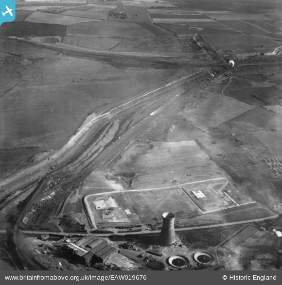
EAW019676 ENGLAND (1948). Part of the John Lysaght Normanby Park Steel Works under construction alongside the Opencast Ironstone Quarry, Scunthorpe, 1948. This image has been produced from a print.
© Copyright OpenStreetMap contributors and licensed by the OpenStreetMap Foundation. 2026. Cartography is licensed as CC BY-SA.
Nearby Images (10)
Details
| Title | [EAW019676] Part of the John Lysaght Normanby Park Steel Works under construction alongside the Opencast Ironstone Quarry, Scunthorpe, 1948. This image has been produced from a print. |
| Reference | EAW019676 |
| Date | 5-October-1948 |
| Link | |
| Place name | SCUNTHORPE |
| Parish | |
| District | |
| Country | ENGLAND |
| Easting / Northing | 489301, 414261 |
| Longitude / Latitude | -0.64984940301576, 53.617034226928 |
| National Grid Reference | SE893143 |
Pins

redmist |
Thursday 31st of January 2019 11:54:28 PM |


![[EAW019676] Part of the John Lysaght Normanby Park Steel Works under construction alongside the Opencast Ironstone Quarry, Scunthorpe, 1948. This image has been produced from a print.](http://britainfromabove.org.uk/sites/all/libraries/aerofilms-images/public/100x100/EAW/019/EAW019676.jpg)
![[EAW038750] Part of the John Lysaght Ltd Normanby Park Steel Works, Scunthorpe, 1951. This image has been produced from a print marked by Aerofilms Ltd for photo editing.](http://britainfromabove.org.uk/sites/all/libraries/aerofilms-images/public/100x100/EAW/038/EAW038750.jpg)
![[EAW019675] Part of the John Lysaght Normanby Park Steel Works under construction alongside the Opencast Ironstone Quarry, Scunthorpe, 1948. This image has been produced from a print.](http://britainfromabove.org.uk/sites/all/libraries/aerofilms-images/public/100x100/EAW/019/EAW019675.jpg)
![[EAW038751] Part of the John Lysaght Ltd Normanby Park Steel Works, Scunthorpe, 1951. This image has been produced from a print marked by Aerofilms Ltd for photo editing.](http://britainfromabove.org.uk/sites/all/libraries/aerofilms-images/public/100x100/EAW/038/EAW038751.jpg)
![[EAW028581] Part of the John Lysaght Normanby Park Steel Works, Scunthorpe, 1950](http://britainfromabove.org.uk/sites/all/libraries/aerofilms-images/public/100x100/EAW/028/EAW028581.jpg)
![[EAW038752] Part of the John Lysaght Ltd Normanby Park Steel Works, Scunthorpe, 1951. This image has been produced from a print.](http://britainfromabove.org.uk/sites/all/libraries/aerofilms-images/public/100x100/EAW/038/EAW038752.jpg)
![[EAW034819] Part of the John Lysaght Normanby Park Steel Works, Scunthorpe, 1951. This image has been produced from a print.](http://britainfromabove.org.uk/sites/all/libraries/aerofilms-images/public/100x100/EAW/034/EAW034819.jpg)
![[EAW031181] The John Lysaght Normanby Park Steel Works, Scunthorpe, 1950](http://britainfromabove.org.uk/sites/all/libraries/aerofilms-images/public/100x100/EAW/031/EAW031181.jpg)
![[EAW034823] Part of the John Lysaght Normanby Park Steel Works, Scunthorpe, 1951. This image has been produced from a print.](http://britainfromabove.org.uk/sites/all/libraries/aerofilms-images/public/100x100/EAW/034/EAW034823.jpg)
![[EAW034818] A cooling tower at the John Lysaght Normanby Park Steel Works under construction, Scunthorpe, 1951. This image has been produced from a print.](http://britainfromabove.org.uk/sites/all/libraries/aerofilms-images/public/100x100/EAW/034/EAW034818.jpg)