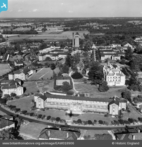
EAW018906 ENGLAND (1948). Shenley Hospital, Shenley, from the south-west, 1948. This image has been produced from a print.
© Copyright OpenStreetMap contributors and licensed by the OpenStreetMap Foundation. 2026. Cartography is licensed as CC BY-SA.
Nearby Images (15)
Details
| Title | [EAW018906] Shenley Hospital, Shenley, from the south-west, 1948. This image has been produced from a print. |
| Reference | EAW018906 |
| Date | 28-September-1948 |
| Link | |
| Place name | SHENLEY |
| Parish | SHENLEY |
| District | |
| Country | ENGLAND |
| Easting / Northing | 517898, 200786 |
| Longitude / Latitude | -0.29405837116701, 51.692967282034 |
| National Grid Reference | TL179008 |
Pins

Matt Aldred edob.mattaldred.com |
Sunday 19th of September 2021 07:37:32 PM | |

Matt Aldred edob.mattaldred.com |
Sunday 19th of September 2021 07:37:25 PM |


![[EAW018906] Shenley Hospital, Shenley, from the south-west, 1948. This image has been produced from a print.](http://britainfromabove.org.uk/sites/all/libraries/aerofilms-images/public/100x100/EAW/018/EAW018906.jpg)
![[EAW018903] Shenley Hospital, Shenley, from the west, 1948. This image has been produced from a print.](http://britainfromabove.org.uk/sites/all/libraries/aerofilms-images/public/100x100/EAW/018/EAW018903.jpg)
![[EAW018902] Shenley Hospital, Shenley, from the west, 1948. This image has been produced from a print.](http://britainfromabove.org.uk/sites/all/libraries/aerofilms-images/public/100x100/EAW/018/EAW018902.jpg)
![[EAW018901] Shenley Hospital, Shenley, from the south-west, 1948. This image has been produced from a print.](http://britainfromabove.org.uk/sites/all/libraries/aerofilms-images/public/100x100/EAW/018/EAW018901.jpg)
![[EPW015745] Porters Park Estate, Shenley, from the south-east, 1926](http://britainfromabove.org.uk/sites/all/libraries/aerofilms-images/public/100x100/EPW/015/EPW015745.jpg)
![[EPW049672] U.S. Navy aircraft in flight over Shenley and Shenley Mental Hospital, Shenley, from the north-west, 1936](http://britainfromabove.org.uk/sites/all/libraries/aerofilms-images/public/100x100/EPW/049/EPW049672.jpg)
![[EAW018900] Shenley Hospital, Shenley, from the south, 1948. This image has been produced from a print.](http://britainfromabove.org.uk/sites/all/libraries/aerofilms-images/public/100x100/EAW/018/EAW018900.jpg)
![[EPW043679] Shenley Mental Hospital and environs, Shenley, 1933. This image has been produced from a damaged negative.](http://britainfromabove.org.uk/sites/all/libraries/aerofilms-images/public/100x100/EPW/043/EPW043679.jpg)
![[EAW018910] Shenley Hospital, Shenley, from the south, 1948](http://britainfromabove.org.uk/sites/all/libraries/aerofilms-images/public/100x100/EAW/018/EAW018910.jpg)
![[EAW019111] Part of the Shenley Hospital Complex and The Mansion, Shenley, 1948](http://britainfromabove.org.uk/sites/all/libraries/aerofilms-images/public/100x100/EAW/019/EAW019111.jpg)
![[EPW044112] The Shenley Psychiatric Hospital, Shenley, 1934](http://britainfromabove.org.uk/sites/all/libraries/aerofilms-images/public/100x100/EPW/044/EPW044112.jpg)
![[EPW043666] Shenley Mental Hospital and environs, Shenley, 1933](http://britainfromabove.org.uk/sites/all/libraries/aerofilms-images/public/100x100/EPW/043/EPW043666.jpg)
![[EPW043669] Shenley Mental Hospital, Shenley, 1933](http://britainfromabove.org.uk/sites/all/libraries/aerofilms-images/public/100x100/EPW/043/EPW043669.jpg)
![[EAW019113] Shenley Hospital, Shenley, from the south, 1948](http://britainfromabove.org.uk/sites/all/libraries/aerofilms-images/public/100x100/EAW/019/EAW019113.jpg)
![[EPW043673] Shenley Mental Hospital, Shenley, from the south-west, 1933. This image has been produced from a damaged negative.](http://britainfromabove.org.uk/sites/all/libraries/aerofilms-images/public/100x100/EPW/043/EPW043673.jpg)