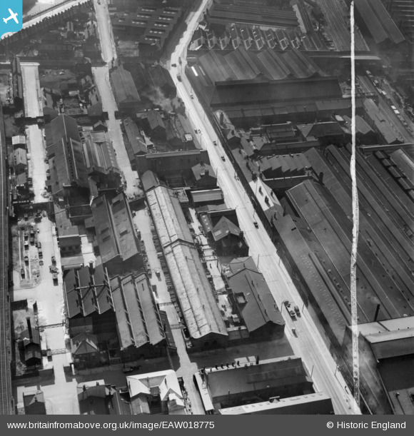
EAW018775 ENGLAND (1948). The Firth-Vickers Stainless Steels Ltd Works on Savile Street East, Burngreave, 1948. This image was marked by Aerofilms Ltd for photo editing.
© Copyright OpenStreetMap contributors and licensed by the OpenStreetMap Foundation. 2026. Cartography is licensed as CC BY-SA.
Nearby Images (35)
Details
| Title | [EAW018775] The Firth-Vickers Stainless Steels Ltd Works on Savile Street East, Burngreave, 1948. This image was marked by Aerofilms Ltd for photo editing. |
| Reference | EAW018775 |
| Date | 21-September-1948 |
| Link | |
| Place name | BURNGREAVE |
| Parish | |
| District | |
| Country | ENGLAND |
| Easting / Northing | 436808, 388550 |
| Longitude / Latitude | -1.4464453290627, 53.392238558296 |
| National Grid Reference | SK368886 |


![[EAW018775] The Firth-Vickers Stainless Steels Ltd Works on Savile Street East, Burngreave, 1948. This image was marked by Aerofilms Ltd for photo editing.](http://britainfromabove.org.uk/sites/all/libraries/aerofilms-images/public/100x100/EAW/018/EAW018775.jpg)
![[EAW009664] The Atlas and Norfolk Steel Works, Sheffield, 1947](http://britainfromabove.org.uk/sites/all/libraries/aerofilms-images/public/100x100/EAW/009/EAW009664.jpg)
![[EAW020089] The Atlas and Norfolk Steel Works, Sheffield, 1948. This image has been produced from a print marked by Aerofilms Ltd for photo editing.](http://britainfromabove.org.uk/sites/all/libraries/aerofilms-images/public/100x100/EAW/020/EAW020089.jpg)
![[EAW020091] The Atlas and Norfolk Steel Works and environs, Sheffield, 1948. This image has been produced from a print marked by Aerofilms Ltd for photo editing.](http://britainfromabove.org.uk/sites/all/libraries/aerofilms-images/public/100x100/EAW/020/EAW020091.jpg)
![[EAW018773] The Firth-Vickers Stainless Steels Ltd Works on Savile Street East, Burngreave, 1948. This image was marked by Aerofilms Ltd for photo editing.](http://britainfromabove.org.uk/sites/all/libraries/aerofilms-images/public/100x100/EAW/018/EAW018773.jpg)
![[EAW020088] The Atlas and Norfolk Steel Works, Sheffield, 1948. This image has been produced from a print marked by Aerofilms Ltd for photo editing.](http://britainfromabove.org.uk/sites/all/libraries/aerofilms-images/public/100x100/EAW/020/EAW020088.jpg)
![[EAW018777] The Firth-Vickers Stainless Steels Ltd Works on Savile Street East and environs, Burngreave, 1948. This image was marked by Aerofilms Ltd for photo editing.](http://britainfromabove.org.uk/sites/all/libraries/aerofilms-images/public/100x100/EAW/018/EAW018777.jpg)
![[EAW018771] The Firth-Vickers Stainless Steels Ltd Works on Savile Street East, Burngreave, 1948. This image was marked by Aerofilms Ltd for photo editing.](http://britainfromabove.org.uk/sites/all/libraries/aerofilms-images/public/100x100/EAW/018/EAW018771.jpg)
![[EAW020095] The Atlas and Norfolk Steel Works and environs, Sheffield, 1948. This image has been produced from a print.](http://britainfromabove.org.uk/sites/all/libraries/aerofilms-images/public/100x100/EAW/020/EAW020095.jpg)
![[EAW018772] The Firth-Vickers Stainless Steels Ltd Works on Savile Street East, Burngreave, 1948. This image was marked by Aerofilms Ltd for photo editing.](http://britainfromabove.org.uk/sites/all/libraries/aerofilms-images/public/100x100/EAW/018/EAW018772.jpg)
![[EAW020090] Corby Street, the Atlas and Norfolk Steel Works and environs, Sheffield, 1948. This image has been produced from a print marked by Aerofilms Ltd for photo editing.](http://britainfromabove.org.uk/sites/all/libraries/aerofilms-images/public/100x100/EAW/020/EAW020090.jpg)
![[EAW020092] The Atlas and Norfolk Steel Works and environs, Sheffield, 1948. This image has been produced from a print marked by Aerofilms Ltd for photo editing.](http://britainfromabove.org.uk/sites/all/libraries/aerofilms-images/public/100x100/EAW/020/EAW020092.jpg)
![[EAW020094] The Atlas and Norfolk Steel Works and environs, Sheffield, 1948. This image has been produced from a print marked by Aerofilms Ltd for photo editing.](http://britainfromabove.org.uk/sites/all/libraries/aerofilms-images/public/100x100/EAW/020/EAW020094.jpg)
![[EAW018778] The Firth-Vickers Stainless Steels Ltd Works on Savile Street East and environs, Burngreave, 1948](http://britainfromabove.org.uk/sites/all/libraries/aerofilms-images/public/100x100/EAW/018/EAW018778.jpg)
![[EAW018804] Steel Works near Greystock Street and Railway Viaduct, Burngreave, 1948. This image has been produced from a print.](http://britainfromabove.org.uk/sites/all/libraries/aerofilms-images/public/100x100/EAW/018/EAW018804.jpg)
![[EAW009666] The Atlas and Norfolk Steel Works, Sheffield, 1947](http://britainfromabove.org.uk/sites/all/libraries/aerofilms-images/public/100x100/EAW/009/EAW009666.jpg)
![[EAW018803] Steel Works near Greystock Street and Railway Viaduct, Burngreave, 1948. This image has been produced from a print.](http://britainfromabove.org.uk/sites/all/libraries/aerofilms-images/public/100x100/EAW/018/EAW018803.jpg)
![[EAW018776] The Firth-Vickers Stainless Steels Ltd Works on Savile Street East, Burngreave, 1948. This image was marked by Aerofilms Ltd for photo editing.](http://britainfromabove.org.uk/sites/all/libraries/aerofilms-images/public/100x100/EAW/018/EAW018776.jpg)
![[EAW018774] The Firth-Vickers Stainless Steels Ltd Works on Savile Street East, Windsor Street and environs, Burngreave, 1948. This image was marked by Aerofilms Ltd for photo editing.](http://britainfromabove.org.uk/sites/all/libraries/aerofilms-images/public/100x100/EAW/018/EAW018774.jpg)
![[EAW009651] The Atlas and Norfolk Steel Works, Sheffield, 1947](http://britainfromabove.org.uk/sites/all/libraries/aerofilms-images/public/100x100/EAW/009/EAW009651.jpg)
![[EAW009661] The Atlas and Norfolk Steel Works, Sheffield, 1947](http://britainfromabove.org.uk/sites/all/libraries/aerofilms-images/public/100x100/EAW/009/EAW009661.jpg)
![[EAW009655] The Atlas and Norfolk Steel Works, Sheffield, 1947](http://britainfromabove.org.uk/sites/all/libraries/aerofilms-images/public/100x100/EAW/009/EAW009655.jpg)
![[EAW009665] The Atlas and Norfolk Steel Works, Sheffield, 1947](http://britainfromabove.org.uk/sites/all/libraries/aerofilms-images/public/100x100/EAW/009/EAW009665.jpg)
![[EAW018779] The Firth-Vickers Stainless Steels Ltd Works on Savile Street East and environs, Burngreave, 1948](http://britainfromabove.org.uk/sites/all/libraries/aerofilms-images/public/100x100/EAW/018/EAW018779.jpg)
![[EAW020093] Corby Street, Greystock Street, Saville Street and environs, Sheffield, 1948. This image has been produced from a print.](http://britainfromabove.org.uk/sites/all/libraries/aerofilms-images/public/100x100/EAW/020/EAW020093.jpg)
![[EAW009663] The Atlas and Norfolk Steel Works, Sheffield, 1947](http://britainfromabove.org.uk/sites/all/libraries/aerofilms-images/public/100x100/EAW/009/EAW009663.jpg)
![[EAW009642] The Atlas and Norfolk Steel Works, Sheffield, 1947](http://britainfromabove.org.uk/sites/all/libraries/aerofilms-images/public/100x100/EAW/009/EAW009642.jpg)
![[EAW009667] The Atlas and Norfolk Steel Works, Sheffield, 1947](http://britainfromabove.org.uk/sites/all/libraries/aerofilms-images/public/100x100/EAW/009/EAW009667.jpg)
![[EAW009645] Greystock Street and environs, Sheffield, 1947](http://britainfromabove.org.uk/sites/all/libraries/aerofilms-images/public/100x100/EAW/009/EAW009645.jpg)
![[EAW009662] The Atlas and Norfolk Steel Works, Sheffield, 1947](http://britainfromabove.org.uk/sites/all/libraries/aerofilms-images/public/100x100/EAW/009/EAW009662.jpg)
![[EAW018802] The Firth-Vickers Stainless Steels Ltd Works on Savile Street East (site of), Burngreave, 1948. This image has been produced from a damaged negative.](http://britainfromabove.org.uk/sites/all/libraries/aerofilms-images/public/100x100/EAW/018/EAW018802.jpg)
![[EAW009660] The Atlas and Norfolk Steel Works, Sheffield, 1947](http://britainfromabove.org.uk/sites/all/libraries/aerofilms-images/public/100x100/EAW/009/EAW009660.jpg)
![[EAW009652] The Atlas and Norfolk Steel Works, Sheffield, 1947](http://britainfromabove.org.uk/sites/all/libraries/aerofilms-images/public/100x100/EAW/009/EAW009652.jpg)
![[EAW009647] The Atlas and Norfolk Steel Works, Sheffield, 1947](http://britainfromabove.org.uk/sites/all/libraries/aerofilms-images/public/100x100/EAW/009/EAW009647.jpg)
![[EAW009640] The Atlas and Norfolk Steel Works, Sheffield, 1947](http://britainfromabove.org.uk/sites/all/libraries/aerofilms-images/public/100x100/EAW/009/EAW009640.jpg)
