Bridgefield Avenue |

dmaudsley |
Tuesday 27th of February 2024 12:44:14 PM |
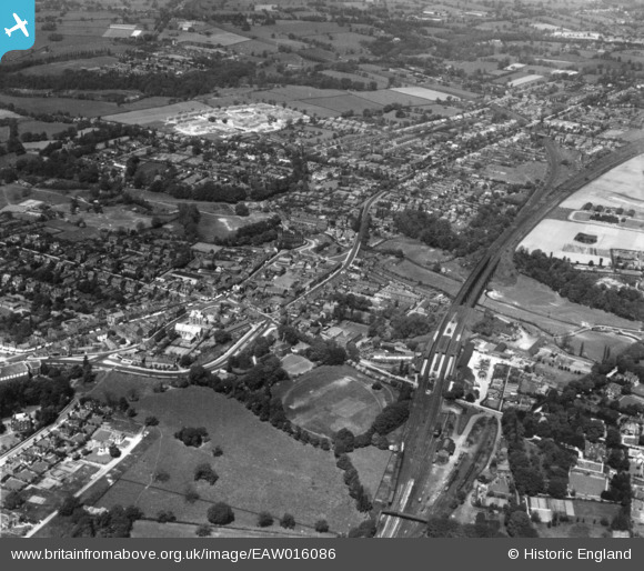
Wilmslow Gas Works.
On the 5th August 1871 during the building of the then 'new' gas works whilst digging about 23ft below ground level the walls collapsed and 8 men were buried, two were saved as they were only partially buried but, unfortunately, the following men lost their lives;
JOHN MOTTRAM,
FREDERICK RICHARDS,
STEPHEN DUFFY,
NOAH WORTH,
GEORGE WORTH,
JOHN PEARSON.
|
Clive Redhead |
Monday 11th of April 2016 09:10:41 PM |
Thorngrove |
Clive Redhead |
Monday 11th of April 2016 08:58:55 PM |
The Rectory (built 1778 for the then Rector of St Bartholomews Church, Rev. Edward Beresford). |
Clive Redhead |
Sunday 10th of April 2016 10:28:41 PM |
Wilmslow Post Office at the corner of Hawthorn Lane and Hawthorn Grove). |
Clive Redhead |
Sunday 10th of April 2016 10:23:55 PM |
Broadway |
Clive Redhead |
Sunday 10th of April 2016 10:15:41 PM |
Green Hall (just off Parkway) |
Clive Redhead |
Sunday 10th of April 2016 10:13:49 PM |
St. Bartholomews Church.
The current church is thought to date from around the 14th / 15th Century though a church is known to have existed on this site in 1246. |
Clive Redhead |
Sunday 10th of April 2016 10:10:40 PM |
Lacey Green Estate (in the process of being built). |
Clive Redhead |
Sunday 10th of April 2016 10:07:27 PM |
The Mill Lade (an off-shoot of the River Bollin which was used to feed the Corn Mill where the Business Park now stands close to the Railway Viaduct).
It started a few yards east of the large Weir on the River Bollin (situated approximately in what is now known as Wilmslow Park between Daveylands to the South and Bollinwood Chase to the North) and meandered beneath the road named Wilmslow Park South via a purpose built red and blue bricked bridge (still in existence, 2016) and on towards the Railway Viaduct which it passed under some 50-100 yards south of where the River Bollin runs (more or less where todays A538 links the A34 to the Manchester Road near St Barts Church). |
Clive Redhead |
Sunday 10th of April 2016 09:58:36 PM |
Mill Lade (not Lane) on off-shoot of the River Bollin which fed water to the Corn Mill (where the Business Park now stands near the Railway Viaduct).
If you walk down Wilmslow Park South from Macclesfield Road about 50-100yds before you reach the River Bollin Bridge you will notice another (near identical bridge) which uses red and blue engineering brick. If you care to look over the side of this bridge you will notice beneath is a small archway. This is where the Mill Lade ran. Unfortunately this area either side of the road is largely overgrown and Lade itself is barely visible. Perhaps the council will place a plaque there one day explaining why the bridge was built as it is no longer self evident. |
Clive Redhead |
Sunday 10th of April 2016 09:44:01 PM |
River Bollin |
Clive Redhead |
Sunday 10th of April 2016 09:33:10 PM |
Cricket Ground (now part of Wilmslow Sports Centre). |
Clive Redhead |
Sunday 10th of April 2016 09:32:29 PM |
Original Railway Bridge which serves a footpath which in turn links 'Land Lane' (on the right in this picture) and the centre of town (to the left) via the Cricket Ground. |
Clive Redhead |
Sunday 10th of April 2016 09:31:19 PM |
Land Lane. An old footpath between Macclesfield Road and Prestbury New Road (A538). Still in regular use today (2016) particularly by locals in the Thorngrove Area of Wilmslow.
In the mid 1960's the southern portion of it (close to where Prestbury Road meets the A34 By-Pass) was upgraded from footpath to a road (a cul-de-sac at the end of Thorngrove Road), still retaining it's original name, Land Lane. This end of Land Lane served as the main entrance to what was then named The Hough Secondary Modern School for Boys (opened 1965) later to become Thorngrove High School which was eventually closed around 1991-92 and demolished 1995-6 to make way for the new housing estate known as Thorngrove Park (built 1996). About half-way along Land Lane (footpath) there is another footpath which runs westwards towards Wilmslow town centre. It spans the A34 by-pass via a modern purpose built footbridge and then utilises an original railway footbridge which spans the Manchester to London Mainline before following a line between the northern perimeter fence of Wilmslow High School and the Wilmslow Sports Centre Cricket Ground and adjacent public car-park. |
Clive Redhead |
Sunday 10th of April 2016 09:27:57 PM |
Land Lane. An old footpath between Macclesfield Road and Prestbury New Road (A538). Still in regular use today (2016) particularly by locals in the Thorngrove Area of Wilmslow.
In the mid 1960's the southern portion of it (close to where Prestbury Road meets the A34 By-Pass) was upgraded from footpath to a road (a cul-de-sac at the end of Thorngrove Road), still retaining it's original name, Land Lane. This end of Land Lane served as the main entrance to what was then named The Hough Secondary Modern School for Boys (opened 1965) later to become Thorngrove High School which was eventually closed around 1991-92 and demolished 1995-6 to make way for the new housing estate known as Thorngrove Park (built 1996). About half-way along Land Lane (footpath) there is another footpath which runs westwards towards Wilmslow town centre. It spans the A34 by-pass via a modern purpose built footbridge and then utilises an original railway footbridge which spans the Manchester to London Mainline before following a line between the northern perimeter fence of Wilmslow High School and the Wilmslow Sports Centre Cricket Ground and adjacent public car-park. |
Clive Redhead |
Sunday 10th of April 2016 09:27:52 PM |
Wilmslow Park, which later became the site of WW2 training camp, RAF Wilmslow. Was then developed for housing becoming Wilmslow Park, Summer fields, during the 1980s, and The Villas housing developments, the latter being completed in 2014. |
Roger |
Friday 2nd of October 2015 07:17:44 PM |
Bollin Hall or its remaining out-buildings, subsequent to construction of the railway line around 1850. |
Roger |
Friday 2nd of October 2015 07:15:58 PM |