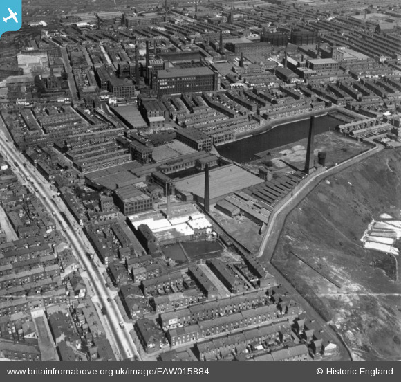
EAW015884 ENGLAND (1948). Fishwick Mills and adjacent cotton mills and terraced housing, Fishwick, 1948. This image has been produced from a print marked by Aerofilms Ltd for photo editing.
© Copyright OpenStreetMap contributors and licensed by the OpenStreetMap Foundation. 2026. Cartography is licensed as CC BY-SA.
Nearby Images (7)
Details
| Title | [EAW015884] Fishwick Mills and adjacent cotton mills and terraced housing, Fishwick, 1948. This image has been produced from a print marked by Aerofilms Ltd for photo editing. |
| Reference | EAW015884 |
| Date | 20-May-1948 |
| Link | |
| Place name | FISHWICK |
| Parish | |
| District | |
| Country | ENGLAND |
| Easting / Northing | 355104, 429375 |
| Longitude / Latitude | -2.681053450144, 53.758577164853 |
| National Grid Reference | SD551294 |
Pins
Be the first to add a comment to this image!


![[EAW015884] Fishwick Mills and adjacent cotton mills and terraced housing, Fishwick, 1948. This image has been produced from a print marked by Aerofilms Ltd for photo editing.](http://britainfromabove.org.uk/sites/all/libraries/aerofilms-images/public/100x100/EAW/015/EAW015884.jpg)
![[EAW015883] Fishwick Mills and adjacent cotton mills and terraced housing, Fishwick, 1948. This image has been produced from a print marked by Aerofilms Ltd for photo editing.](http://britainfromabove.org.uk/sites/all/libraries/aerofilms-images/public/100x100/EAW/015/EAW015883.jpg)
![[EAW015885] Fishwick Mills and adjacent cotton mills and terraced housing, Fishwick, 1948. This image has been produced from a print marked by Aerofilms Ltd for photo editing.](http://britainfromabove.org.uk/sites/all/libraries/aerofilms-images/public/100x100/EAW/015/EAW015885.jpg)
![[EAW015881] Cotton mills and terraced housing, Fishwick, 1948. This image has been produced from a print marked by Aerofilms Ltd for photo editing.](http://britainfromabove.org.uk/sites/all/libraries/aerofilms-images/public/100x100/EAW/015/EAW015881.jpg)
![[EAW015882] Fishwick Mills and adjacent cotton mills and terraced housing, Fishwick, 1948. This image has been produced from a print marked by Aerofilms Ltd for photo editing.](http://britainfromabove.org.uk/sites/all/libraries/aerofilms-images/public/100x100/EAW/015/EAW015882.jpg)
![[EAW015887] Fishwick Mills and adjacent cotton mills and terraced housing, Fishwick, 1948. This image has been produced from a print marked by Aerofilms Ltd for photo editing.](http://britainfromabove.org.uk/sites/all/libraries/aerofilms-images/public/100x100/EAW/015/EAW015887.jpg)
![[EAW015886] The city, Preston, from the east, 1948. This image has been produced from a print marked by Aerofilms Ltd for photo editing.](http://britainfromabove.org.uk/sites/all/libraries/aerofilms-images/public/100x100/EAW/015/EAW015886.jpg)