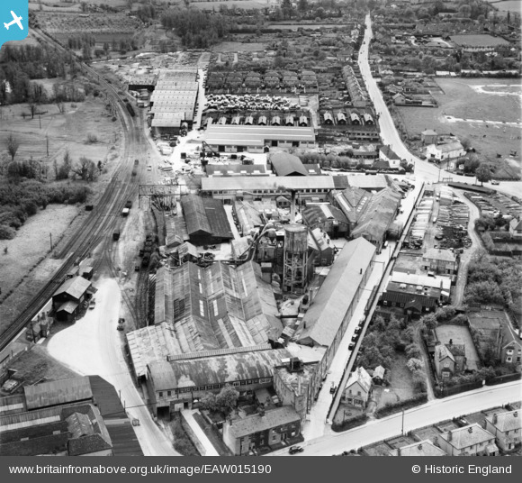
EAW015190 ENGLAND (1948). The Rippers Ltd Joinery Works on Station Road and environs, Sible Hedingham, 1948
© Copyright OpenStreetMap contributors and licensed by the OpenStreetMap Foundation. 2026. Cartography is licensed as CC BY-SA.
Nearby Images (15)
Details
| Title | [EAW015190] The Rippers Ltd Joinery Works on Station Road and environs, Sible Hedingham, 1948 |
| Reference | EAW015190 |
| Date | 5-May-1948 |
| Link | |
| Place name | SIBLE HEDINGHAM |
| Parish | SIBLE HEDINGHAM |
| District | |
| Country | ENGLAND |
| Easting / Northing | 578065, 234650 |
| Longitude / Latitude | 0.59317084983364, 51.981304243294 |
| National Grid Reference | TL781347 |
Pins
Be the first to add a comment to this image!


![[EAW015190] The Rippers Ltd Joinery Works on Station Road and environs, Sible Hedingham, 1948](http://britainfromabove.org.uk/sites/all/libraries/aerofilms-images/public/100x100/EAW/015/EAW015190.jpg)
![[EAW015189] The Rippers Ltd Joinery Works on Station Road and environs, Sible Hedingham, 1948](http://britainfromabove.org.uk/sites/all/libraries/aerofilms-images/public/100x100/EAW/015/EAW015189.jpg)
![[EPW025965] The Rippers Ltd Joinery Works and Sible and Castle Hedingham Railway Station, Sible Hedingham, 1929](http://britainfromabove.org.uk/sites/all/libraries/aerofilms-images/public/100x100/EPW/025/EPW025965.jpg)
![[EPW025973] The Rippers Ltd Joinery Works, Sible Hedingham, 1929](http://britainfromabove.org.uk/sites/all/libraries/aerofilms-images/public/100x100/EPW/025/EPW025973.jpg)
![[EPW025970] The Rippers Ltd Joinery Works and Sible and Castle Hedingham Railway Station, Sible Hedingham, 1929](http://britainfromabove.org.uk/sites/all/libraries/aerofilms-images/public/100x100/EPW/025/EPW025970.jpg)
![[EAW015198] The Rippers Ltd Joinery Works on Station Road and environs, Sible Hedingham, 1948](http://britainfromabove.org.uk/sites/all/libraries/aerofilms-images/public/100x100/EAW/015/EAW015198.jpg)
![[EAW015199] The Rippers Ltd Joinery Works on Station Road and environs, Sible Hedingham, 1948](http://britainfromabove.org.uk/sites/all/libraries/aerofilms-images/public/100x100/EAW/015/EAW015199.jpg)
![[EPW025971] The Rippers Ltd Joinery Works and Sible and Castle Hedingham Railway Station, Sible Hedingham, 1929](http://britainfromabove.org.uk/sites/all/libraries/aerofilms-images/public/100x100/EPW/025/EPW025971.jpg)
![[EPW025968] The Rippers Ltd Joinery Works and Sible and Castle Hedingham Railway Station, Sible Hedingham, 1929](http://britainfromabove.org.uk/sites/all/libraries/aerofilms-images/public/100x100/EPW/025/EPW025968.jpg)
![[EAW015192] The village and surrounding countryside, Sible Hedingham, 1948](http://britainfromabove.org.uk/sites/all/libraries/aerofilms-images/public/100x100/EAW/015/EAW015192.jpg)
![[EPW025972] Housing off Swan Street and Rippers Ltd Joinery Works, Sible Hedingham, 1929](http://britainfromabove.org.uk/sites/all/libraries/aerofilms-images/public/100x100/EPW/025/EPW025972.jpg)
![[EPW025969] Housing off Swan Street and Rippers Ltd Joinery Works, Sible Hedingham, 1929](http://britainfromabove.org.uk/sites/all/libraries/aerofilms-images/public/100x100/EPW/025/EPW025969.jpg)
![[EPW025963] Housing off Swan Street and Rippers Ltd Joinery Works, Sible Hedingham, 1929](http://britainfromabove.org.uk/sites/all/libraries/aerofilms-images/public/100x100/EPW/025/EPW025963.jpg)
![[EPW025975] Housing off Swan Street and Rippers Ltd Joinery Works, Sible Hedingham, 1929](http://britainfromabove.org.uk/sites/all/libraries/aerofilms-images/public/100x100/EPW/025/EPW025975.jpg)
![[EPW025967] Housing off Swan Street and Rippers Ltd Joinery Works, Sible Hedingham, 1929](http://britainfromabove.org.uk/sites/all/libraries/aerofilms-images/public/100x100/EPW/025/EPW025967.jpg)