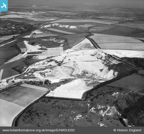
EAW014292 ENGLAND (1948). Chalk Pits alongside Totternhoe Castle, Totternhoe, from the west, 1948
© Copyright OpenStreetMap contributors and licensed by the OpenStreetMap Foundation. 2025. Cartography is licensed as CC BY-SA.
Details
| Title | [EAW014292] Chalk Pits alongside Totternhoe Castle, Totternhoe, from the west, 1948 |
| Reference | EAW014292 |
| Date | 12-April-1948 |
| Link | |
| Place name | TOTTERNHOE |
| Parish | TOTTERNHOE |
| District | |
| Country | ENGLAND |
| Easting / Northing | 497914, 222198 |
| Longitude / Latitude | -0.57706881860852, 51.889288473644 |
| National Grid Reference | SP979222 |
Pins

DD |
Friday 24th of February 2017 11:45:50 AM | |

Dylan Moore |
Tuesday 24th of December 2013 06:37:05 PM | |

Dylan Moore |
Tuesday 24th of December 2013 06:36:21 PM | |

Dylan Moore |
Tuesday 24th of December 2013 06:35:27 PM |


![[EAW014292] Chalk Pits alongside Totternhoe Castle, Totternhoe, from the west, 1948](http://britainfromabove.org.uk/sites/all/libraries/aerofilms-images/public/100x100/EAW/014/EAW014292.jpg)
![[EAW014295] Totternhoe Castle, Totternhoe, 1948](http://britainfromabove.org.uk/sites/all/libraries/aerofilms-images/public/100x100/EAW/014/EAW014295.jpg)
![[EAW014294] Totternhoe Castle and the surrounding countryside, Totternhoe, from the south-west, 1948](http://britainfromabove.org.uk/sites/all/libraries/aerofilms-images/public/100x100/EAW/014/EAW014294.jpg)