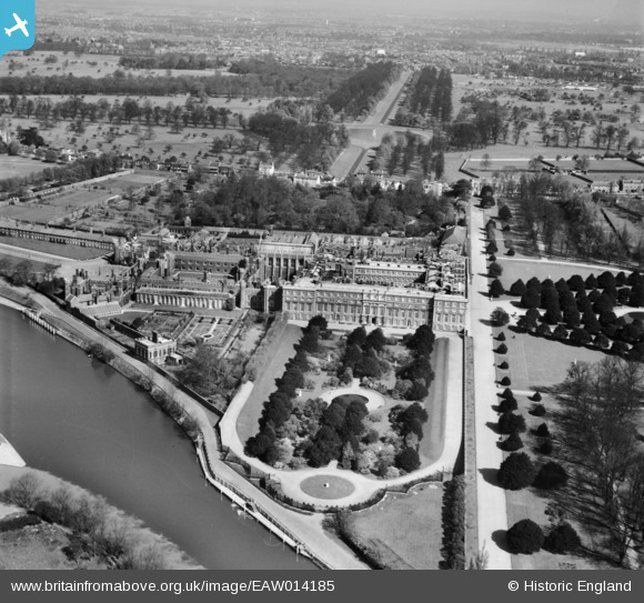
EAW014185 ENGLAND (1948). Hampton Court Palace, Hampton Court Park, from the south, 1948
© Copyright OpenStreetMap contributors and licensed by the OpenStreetMap Foundation. 2026. Cartography is licensed as CC BY-SA.
Nearby Images (31)
Details
| Title | [EAW014185] Hampton Court Palace, Hampton Court Park, from the south, 1948 |
| Reference | EAW014185 |
| Date | 7-April-1948 |
| Link | |
| Place name | HAMPTON COURT PARK |
| Parish | |
| District | |
| Country | ENGLAND |
| Easting / Northing | 515735, 168289 |
| Longitude / Latitude | -0.33603419414249, 51.401314486244 |
| National Grid Reference | TQ157683 |
Pins

Alan McFaden |
Wednesday 8th of January 2014 05:18:11 PM | |

Alan McFaden |
Wednesday 8th of January 2014 05:17:36 PM | |

Pip |
Thursday 2nd of January 2014 03:42:54 AM |


![[EAW014185] Hampton Court Palace, Hampton Court Park, from the south, 1948](http://britainfromabove.org.uk/sites/all/libraries/aerofilms-images/public/100x100/EAW/014/EAW014185.jpg)
![[EPW001711] Hampton Court Palace, Hampton Court Park, 1920](http://britainfromabove.org.uk/sites/all/libraries/aerofilms-images/public/100x100/EPW/001/EPW001711.jpg)
![[EAW014186] Hampton Court Palace and environs, Hampton Court Park, from the south-east, 1948](http://britainfromabove.org.uk/sites/all/libraries/aerofilms-images/public/100x100/EAW/014/EAW014186.jpg)
![[EPW001713] Hampton Court Palace, Hampton Court Park, 1920](http://britainfromabove.org.uk/sites/all/libraries/aerofilms-images/public/100x100/EPW/001/EPW001713.jpg)
![[EPW031566] Hampton Court Palace and Park looking towards Hampton Court Station, Hampton Court Park, from the east, 1930. This image has been produced from a print.](http://britainfromabove.org.uk/sites/all/libraries/aerofilms-images/public/100x100/EPW/031/EPW031566.jpg)
![[EPW001712] Hampton Court Palace, Hampton Court Park, 1920](http://britainfromabove.org.uk/sites/all/libraries/aerofilms-images/public/100x100/EPW/001/EPW001712.jpg)
![[EPW022946] Hampton Court Palace, Hampton Court Park, 1928](http://britainfromabove.org.uk/sites/all/libraries/aerofilms-images/public/100x100/EPW/022/EPW022946.jpg)
![[EAW023684] Hampton Court Palace, Hampton Court Park, 1949](http://britainfromabove.org.uk/sites/all/libraries/aerofilms-images/public/100x100/EAW/023/EAW023684.jpg)
![[EPW022853] Hampton Court Palace, Hampton Court Park, 1928](http://britainfromabove.org.uk/sites/all/libraries/aerofilms-images/public/100x100/EPW/022/EPW022853.jpg)
![[EAW014181] Hampton Court Palace, Hampton Court Park, 1948](http://britainfromabove.org.uk/sites/all/libraries/aerofilms-images/public/100x100/EAW/014/EAW014181.jpg)
![[EPW010997] Hampton Court Palace, Hampton Court Park, from the south-east, 1924. This image has been produced from a copy-negative.](http://britainfromabove.org.uk/sites/all/libraries/aerofilms-images/public/100x100/EPW/010/EPW010997.jpg)
![[EPW009439] Hampton Court Palace, Hampton Court Park, 1923](http://britainfromabove.org.uk/sites/all/libraries/aerofilms-images/public/100x100/EPW/009/EPW009439.jpg)
![[EPW022852] Hampton Court Palace, Hampton Court Park, 1928](http://britainfromabove.org.uk/sites/all/libraries/aerofilms-images/public/100x100/EPW/022/EPW022852.jpg)
![[EAW023683] Hampton Court Palace, Hampton Court Park, 1949](http://britainfromabove.org.uk/sites/all/libraries/aerofilms-images/public/100x100/EAW/023/EAW023683.jpg)
![[EPW060551] Hampton Court Palace, Hampton Court Park, 1939. This image has been produced from a print.](http://britainfromabove.org.uk/sites/all/libraries/aerofilms-images/public/100x100/EPW/060/EPW060551.jpg)
![[EPW001716] Hampton Court Palace and Station, Hampton Court Park, 1920](http://britainfromabove.org.uk/sites/all/libraries/aerofilms-images/public/100x100/EPW/001/EPW001716.jpg)
![[EAW018711] Hampton Court Palace, Hampton Court Park, 1948. This image has been produced from a print.](http://britainfromabove.org.uk/sites/all/libraries/aerofilms-images/public/100x100/EAW/018/EAW018711.jpg)
![[EAW014184] Hampton Court Palace, Hampton Court Park, 1948](http://britainfromabove.org.uk/sites/all/libraries/aerofilms-images/public/100x100/EAW/014/EAW014184.jpg)
![[EAW014182] Hampton Court Palace, Hampton Court Park, 1948](http://britainfromabove.org.uk/sites/all/libraries/aerofilms-images/public/100x100/EAW/014/EAW014182.jpg)
![[EPW060550] Hampton Court Palace, Hampton Court Park, 1939. This image has been produced from a damaged negative.](http://britainfromabove.org.uk/sites/all/libraries/aerofilms-images/public/100x100/EPW/060/EPW060550.jpg)
![[EPW008866] Hampton Court Palace, Hampton Court Park, 1923](http://britainfromabove.org.uk/sites/all/libraries/aerofilms-images/public/100x100/EPW/008/EPW008866.jpg)
![[EAW003680] The River Thames in flood surrounding Hampton Court Railway Station and Ditton Field, Thames Ditton, from the north-west, 1947](http://britainfromabove.org.uk/sites/all/libraries/aerofilms-images/public/100x100/EAW/003/EAW003680.jpg)
![[EPW022848] Hampton Court Palace, Hampton Court Park, 1928](http://britainfromabove.org.uk/sites/all/libraries/aerofilms-images/public/100x100/EPW/022/EPW022848.jpg)
![[EAW002300] Hampton Court Palace, Hampton Court Park, 1946](http://britainfromabove.org.uk/sites/all/libraries/aerofilms-images/public/100x100/EAW/002/EAW002300.jpg)
![[EAW018712] Hampton Court Palace, Hampton Court Park, 1948. This image has been produced from a print.](http://britainfromabove.org.uk/sites/all/libraries/aerofilms-images/public/100x100/EAW/018/EAW018712.jpg)
![[EAW023679] Crowds along the bank of the River Thames at Cigarette Island Park and Hampton Court Bridge, East Molesey, 1949](http://britainfromabove.org.uk/sites/all/libraries/aerofilms-images/public/100x100/EAW/023/EAW023679.jpg)
![[EAW002302] Hampton Court Palace, Hampton Court Park, 1946](http://britainfromabove.org.uk/sites/all/libraries/aerofilms-images/public/100x100/EAW/002/EAW002302.jpg)
![[EAW002301] Hampton Court Palace, Hampton Court Park, 1946](http://britainfromabove.org.uk/sites/all/libraries/aerofilms-images/public/100x100/EAW/002/EAW002301.jpg)
![[EPW060552] Hampton Court Palace, Hampton Court Park, 1939](http://britainfromabove.org.uk/sites/all/libraries/aerofilms-images/public/100x100/EPW/060/EPW060552.jpg)
![[EPW049573] The River Thames at Hampton Court Palace and environs, Hampton Court Park, 1936. This image has been produced from a damaged negative.](http://britainfromabove.org.uk/sites/all/libraries/aerofilms-images/public/100x100/EPW/049/EPW049573.jpg)
![[EPW060549] Hampton Court Palace, Hampton Court Park, 1939](http://britainfromabove.org.uk/sites/all/libraries/aerofilms-images/public/100x100/EPW/060/EPW060549.jpg)

