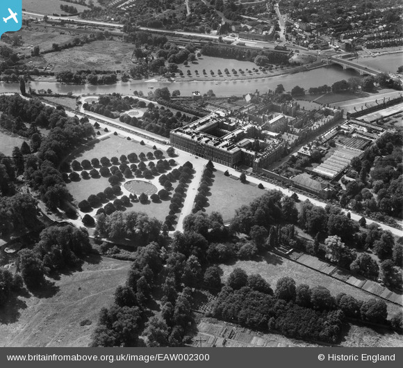
EAW002300 ENGLAND (1946). Hampton Court Palace, Hampton Court Park, 1946
© Copyright OpenStreetMap contributors and licensed by the OpenStreetMap Foundation. 2026. Cartography is licensed as CC BY-SA.
Nearby Images (27)
Details
| Title | [EAW002300] Hampton Court Palace, Hampton Court Park, 1946 |
| Reference | EAW002300 |
| Date | 21-August-1946 |
| Link | |
| Place name | HAMPTON COURT PARK |
| Parish | |
| District | |
| Country | ENGLAND |
| Easting / Northing | 515863, 168466 |
| Longitude / Latitude | -0.3341369090867, 51.402879376771 |
| National Grid Reference | TQ159685 |
Pins

Matt Aldred edob.mattaldred.com |
Friday 27th of September 2024 07:03:02 PM | |

Matt Aldred edob.mattaldred.com |
Friday 27th of September 2024 07:02:43 PM | |

Matt Aldred edob.mattaldred.com |
Friday 27th of September 2024 07:01:52 PM | |

Matt Aldred edob.mattaldred.com |
Friday 27th of September 2024 07:01:38 PM | |

Matt Aldred edob.mattaldred.com |
Friday 27th of September 2024 07:01:07 PM | |

Alan McFaden |
Tuesday 21st of January 2014 08:36:49 PM | |

Alan McFaden |
Tuesday 21st of January 2014 08:36:12 PM | |

Alan McFaden |
Tuesday 21st of January 2014 08:35:36 PM | |

Pip |
Thursday 2nd of January 2014 03:34:16 AM |


![[EAW002300] Hampton Court Palace, Hampton Court Park, 1946](http://britainfromabove.org.uk/sites/all/libraries/aerofilms-images/public/100x100/EAW/002/EAW002300.jpg)
![[EPW060549] Hampton Court Palace, Hampton Court Park, 1939](http://britainfromabove.org.uk/sites/all/libraries/aerofilms-images/public/100x100/EPW/060/EPW060549.jpg)
![[EAW014184] Hampton Court Palace, Hampton Court Park, 1948](http://britainfromabove.org.uk/sites/all/libraries/aerofilms-images/public/100x100/EAW/014/EAW014184.jpg)
![[EPW022852] Hampton Court Palace, Hampton Court Park, 1928](http://britainfromabove.org.uk/sites/all/libraries/aerofilms-images/public/100x100/EPW/022/EPW022852.jpg)
![[EPW022848] Hampton Court Palace, Hampton Court Park, 1928](http://britainfromabove.org.uk/sites/all/libraries/aerofilms-images/public/100x100/EPW/022/EPW022848.jpg)
![[EPW060551] Hampton Court Palace, Hampton Court Park, 1939. This image has been produced from a print.](http://britainfromabove.org.uk/sites/all/libraries/aerofilms-images/public/100x100/EPW/060/EPW060551.jpg)
![[EPW010997] Hampton Court Palace, Hampton Court Park, from the south-east, 1924. This image has been produced from a copy-negative.](http://britainfromabove.org.uk/sites/all/libraries/aerofilms-images/public/100x100/EPW/010/EPW010997.jpg)
![[EAW014181] Hampton Court Palace, Hampton Court Park, 1948](http://britainfromabove.org.uk/sites/all/libraries/aerofilms-images/public/100x100/EAW/014/EAW014181.jpg)
![[EAW018712] Hampton Court Palace, Hampton Court Park, 1948. This image has been produced from a print.](http://britainfromabove.org.uk/sites/all/libraries/aerofilms-images/public/100x100/EAW/018/EAW018712.jpg)
![[EPW060552] Hampton Court Palace, Hampton Court Park, 1939](http://britainfromabove.org.uk/sites/all/libraries/aerofilms-images/public/100x100/EPW/060/EPW060552.jpg)
![[EPW060550] Hampton Court Palace, Hampton Court Park, 1939. This image has been produced from a damaged negative.](http://britainfromabove.org.uk/sites/all/libraries/aerofilms-images/public/100x100/EPW/060/EPW060550.jpg)
![[EPW022853] Hampton Court Palace, Hampton Court Park, 1928](http://britainfromabove.org.uk/sites/all/libraries/aerofilms-images/public/100x100/EPW/022/EPW022853.jpg)
![[EAW014182] Hampton Court Palace, Hampton Court Park, 1948](http://britainfromabove.org.uk/sites/all/libraries/aerofilms-images/public/100x100/EAW/014/EAW014182.jpg)
![[EPW009439] Hampton Court Palace, Hampton Court Park, 1923](http://britainfromabove.org.uk/sites/all/libraries/aerofilms-images/public/100x100/EPW/009/EPW009439.jpg)
![[EAW002301] Hampton Court Palace, Hampton Court Park, 1946](http://britainfromabove.org.uk/sites/all/libraries/aerofilms-images/public/100x100/EAW/002/EAW002301.jpg)
![[EPW022946] Hampton Court Palace, Hampton Court Park, 1928](http://britainfromabove.org.uk/sites/all/libraries/aerofilms-images/public/100x100/EPW/022/EPW022946.jpg)
![[EAW023684] Hampton Court Palace, Hampton Court Park, 1949](http://britainfromabove.org.uk/sites/all/libraries/aerofilms-images/public/100x100/EAW/023/EAW023684.jpg)
![[EAW023683] Hampton Court Palace, Hampton Court Park, 1949](http://britainfromabove.org.uk/sites/all/libraries/aerofilms-images/public/100x100/EAW/023/EAW023683.jpg)
![[EPW008866] Hampton Court Palace, Hampton Court Park, 1923](http://britainfromabove.org.uk/sites/all/libraries/aerofilms-images/public/100x100/EPW/008/EPW008866.jpg)
![[EAW018711] Hampton Court Palace, Hampton Court Park, 1948. This image has been produced from a print.](http://britainfromabove.org.uk/sites/all/libraries/aerofilms-images/public/100x100/EAW/018/EAW018711.jpg)
![[EAW002302] Hampton Court Palace, Hampton Court Park, 1946](http://britainfromabove.org.uk/sites/all/libraries/aerofilms-images/public/100x100/EAW/002/EAW002302.jpg)
![[EPW001711] Hampton Court Palace, Hampton Court Park, 1920](http://britainfromabove.org.uk/sites/all/libraries/aerofilms-images/public/100x100/EPW/001/EPW001711.jpg)
![[EAW014186] Hampton Court Palace and environs, Hampton Court Park, from the south-east, 1948](http://britainfromabove.org.uk/sites/all/libraries/aerofilms-images/public/100x100/EAW/014/EAW014186.jpg)
![[EPW001713] Hampton Court Palace, Hampton Court Park, 1920](http://britainfromabove.org.uk/sites/all/libraries/aerofilms-images/public/100x100/EPW/001/EPW001713.jpg)
![[EPW031566] Hampton Court Palace and Park looking towards Hampton Court Station, Hampton Court Park, from the east, 1930. This image has been produced from a print.](http://britainfromabove.org.uk/sites/all/libraries/aerofilms-images/public/100x100/EPW/031/EPW031566.jpg)
![[EAW014185] Hampton Court Palace, Hampton Court Park, from the south, 1948](http://britainfromabove.org.uk/sites/all/libraries/aerofilms-images/public/100x100/EAW/014/EAW014185.jpg)
![[EPW001712] Hampton Court Palace, Hampton Court Park, 1920](http://britainfromabove.org.uk/sites/all/libraries/aerofilms-images/public/100x100/EPW/001/EPW001712.jpg)


