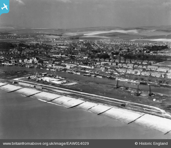
EAW014029 ENGLAND (1948). Shoreham Harbour and Brighton B Power Station under construction, Southwick, from the south, 1948. This image has been produced from a print.
© Copyright OpenStreetMap contributors and licensed by the OpenStreetMap Foundation. 2026. Cartography is licensed as CC BY-SA.
Nearby Images (9)
Details
| Title | [EAW014029] Shoreham Harbour and Brighton B Power Station under construction, Southwick, from the south, 1948. This image has been produced from a print. |
| Reference | EAW014029 |
| Date | 23-March-1948 |
| Link | |
| Place name | SOUTHWICK |
| Parish | |
| District | |
| Country | ENGLAND |
| Easting / Northing | 524719, 104802 |
| Longitude / Latitude | -0.22889102042808, 50.828741378265 |
| National Grid Reference | TQ247048 |


![[EAW014029] Shoreham Harbour and Brighton B Power Station under construction, Southwick, from the south, 1948. This image has been produced from a print.](http://britainfromabove.org.uk/sites/all/libraries/aerofilms-images/public/100x100/EAW/014/EAW014029.jpg)
![[EAW014025] Shoreham Harbour and Brighton B Power Station under construction, Southwick, from the south, 1948](http://britainfromabove.org.uk/sites/all/libraries/aerofilms-images/public/100x100/EAW/014/EAW014025.jpg)
![[EAW014028] Shoreham Harbour and Brighton B Power Station under construction, Southwick, from the south-west, 1948. This image has been produced from a print.](http://britainfromabove.org.uk/sites/all/libraries/aerofilms-images/public/100x100/EAW/014/EAW014028.jpg)
![[EAW014026] Brighton B Power Station under construction, Southwick, 1948](http://britainfromabove.org.uk/sites/all/libraries/aerofilms-images/public/100x100/EAW/014/EAW014026.jpg)
![[EPW043906] Shoreham Harbour, The Canal and the town of Portslade-by-Sea, Southwick, from the west, 1934](http://britainfromabove.org.uk/sites/all/libraries/aerofilms-images/public/100x100/EPW/043/EPW043906.jpg)
![[EAW014021] Shoreham Harbour and environs, Southwick, 1948](http://britainfromabove.org.uk/sites/all/libraries/aerofilms-images/public/100x100/EAW/014/EAW014021.jpg)
![[EAW014027] Shoreham Harbour and Brighton B Power Station under construction, Southwick, 1948](http://britainfromabove.org.uk/sites/all/libraries/aerofilms-images/public/100x100/EAW/014/EAW014027.jpg)
![[EAW014022] Shoreham Harbour and environs, Southwick, from the west, 1948. This image has been produced from a damaged negative.](http://britainfromabove.org.uk/sites/all/libraries/aerofilms-images/public/100x100/EAW/014/EAW014022.jpg)
![[EPW043901] Shoreham Harbour, The Canal and the town of Portslade-by-Sea, Southwick, from the west, 1934](http://britainfromabove.org.uk/sites/all/libraries/aerofilms-images/public/100x100/EPW/043/EPW043901.jpg)
