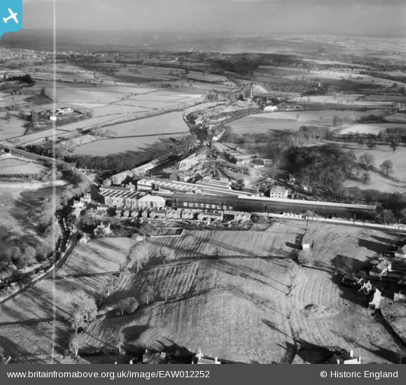
EAW012252 ENGLAND (1947). The Butterley Iron Works and environs, Butterley, from the west, 1947. This image was marked by Aerofilms Ltd for photo editing.
© Copyright OpenStreetMap contributors and licensed by the OpenStreetMap Foundation. 2026. Cartography is licensed as CC BY-SA.
Nearby Images (14)
Details
| Title | [EAW012252] The Butterley Iron Works and environs, Butterley, from the west, 1947. This image was marked by Aerofilms Ltd for photo editing. |
| Reference | EAW012252 |
| Date | 24-November-1947 |
| Link | |
| Place name | BUTTERLEY |
| Parish | RIPLEY |
| District | |
| Country | ENGLAND |
| Easting / Northing | 439900, 351497 |
| Longitude / Latitude | -1.4045857789625, 53.058930194569 |
| National Grid Reference | SK399515 |
Pins
Be the first to add a comment to this image!


![[EAW012252] The Butterley Iron Works and environs, Butterley, from the west, 1947. This image was marked by Aerofilms Ltd for photo editing.](http://britainfromabove.org.uk/sites/all/libraries/aerofilms-images/public/100x100/EAW/012/EAW012252.jpg)
![[EAW012261] The Butterley Iron Works and environs, Butterley, from the west, 1947. This image was marked by Aerofilms Ltd for photo editing.](http://britainfromabove.org.uk/sites/all/libraries/aerofilms-images/public/100x100/EAW/012/EAW012261.jpg)
![[EAW012253] The Butterley Iron Works and environs, Butterley, from the west, 1947. This image was marked by Aerofilms Ltd for photo editing.](http://britainfromabove.org.uk/sites/all/libraries/aerofilms-images/public/100x100/EAW/012/EAW012253.jpg)
![[EAW012248] The Butterley Iron Works and environs, Butterley, from the west, 1947. This image was marked by Aerofilms Ltd for photo editing.](http://britainfromabove.org.uk/sites/all/libraries/aerofilms-images/public/100x100/EAW/012/EAW012248.jpg)
![[EAW012249] The Butterley Iron Works and environs, Butterley, from the west, 1947. This image was marked by Aerofilms Ltd for photo editing.](http://britainfromabove.org.uk/sites/all/libraries/aerofilms-images/public/100x100/EAW/012/EAW012249.jpg)
![[EAW012250] The Butterley Iron Works and environs, Butterley, from the north-west, 1947](http://britainfromabove.org.uk/sites/all/libraries/aerofilms-images/public/100x100/EAW/012/EAW012250.jpg)
![[EAW012254] The Butterley Iron Works and environs, Butterley, from the north-west, 1947. This image was marked by Aerofilms Ltd for photo editing.](http://britainfromabove.org.uk/sites/all/libraries/aerofilms-images/public/100x100/EAW/012/EAW012254.jpg)
![[EAW012255] The Butterley Iron Works and environs, Butterley, from the north-west, 1947. This image was marked by Aerofilms Ltd for photo editing.](http://britainfromabove.org.uk/sites/all/libraries/aerofilms-images/public/100x100/EAW/012/EAW012255.jpg)
![[EAW012251] The Butterley Iron Works and environs, Butterley, from the south-west, 1947. This image was marked by Aerofilms Ltd for photo editing.](http://britainfromabove.org.uk/sites/all/libraries/aerofilms-images/public/100x100/EAW/012/EAW012251.jpg)
![[EAW012262] The Butterley Iron Works and environs, Butterley, from the north-west, 1947. This image has been produced from a damaged negative.](http://britainfromabove.org.uk/sites/all/libraries/aerofilms-images/public/100x100/EAW/012/EAW012262.jpg)
![[EAW012256] The Butterley Iron Works and environs, Butterley, from the north-west, 1947](http://britainfromabove.org.uk/sites/all/libraries/aerofilms-images/public/100x100/EAW/012/EAW012256.jpg)
![[EPW050253] The Butterley Co Iron Works, Butterley, 1936](http://britainfromabove.org.uk/sites/all/libraries/aerofilms-images/public/100x100/EPW/050/EPW050253.jpg)
![[EPW050254] The Butterley Co Iron Works, Butterley, 1936](http://britainfromabove.org.uk/sites/all/libraries/aerofilms-images/public/100x100/EPW/050/EPW050254.jpg)
![[EPW050251] The Butterley Co Iron Works, Butterley, 1936](http://britainfromabove.org.uk/sites/all/libraries/aerofilms-images/public/100x100/EPW/050/EPW050251.jpg)