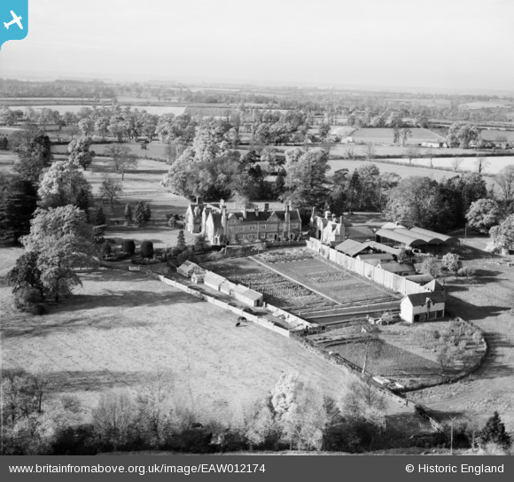
EAW012174 ENGLAND (1947). Crawley Grange, North Crawley, from the east, 1947
© Copyright OpenStreetMap contributors and licensed by the OpenStreetMap Foundation. 2025. Cartography is licensed as CC BY-SA.
Nearby Images (10)
Details
| Title | [EAW012174] Crawley Grange, North Crawley, from the east, 1947 |
| Reference | EAW012174 |
| Date | 10-November-1947 |
| Link | |
| Place name | NORTH CRAWLEY |
| Parish | NORTH CRAWLEY |
| District | |
| Country | ENGLAND |
| Easting / Northing | 493290, 244901 |
| Longitude / Latitude | -0.63806739116966, 52.094163984656 |
| National Grid Reference | SP933449 |
Pins
Be the first to add a comment to this image!


![[EAW012174] Crawley Grange, North Crawley, from the east, 1947](http://britainfromabove.org.uk/sites/all/libraries/aerofilms-images/public/100x100/EAW/012/EAW012174.jpg)
![[EAW012169] Crawley Grange and surrounding countryside, North Crawley, 1947](http://britainfromabove.org.uk/sites/all/libraries/aerofilms-images/public/100x100/EAW/012/EAW012169.jpg)
![[EAW012175] Crawley Grange, North Crawley, 1947](http://britainfromabove.org.uk/sites/all/libraries/aerofilms-images/public/100x100/EAW/012/EAW012175.jpg)
![[EAW012168] Crawley Grange and Cranfield Road, North Crawley, 1947](http://britainfromabove.org.uk/sites/all/libraries/aerofilms-images/public/100x100/EAW/012/EAW012168.jpg)
![[EAW012167] Crawley Grange, North Crawley, 1947](http://britainfromabove.org.uk/sites/all/libraries/aerofilms-images/public/100x100/EAW/012/EAW012167.jpg)
![[EAW012172] Crawley Grange, North Crawley, 1947](http://britainfromabove.org.uk/sites/all/libraries/aerofilms-images/public/100x100/EAW/012/EAW012172.jpg)
![[EAW012171] Crawley Grange, North Crawley, 1947](http://britainfromabove.org.uk/sites/all/libraries/aerofilms-images/public/100x100/EAW/012/EAW012171.jpg)
![[EAW012170] Crawley Grange and the village, North Crawley, 1947](http://britainfromabove.org.uk/sites/all/libraries/aerofilms-images/public/100x100/EAW/012/EAW012170.jpg)
![[EAW012173] Crawley Grange, North Crawley, 1947](http://britainfromabove.org.uk/sites/all/libraries/aerofilms-images/public/100x100/EAW/012/EAW012173.jpg)
![[EAW012166] Crawley Grange and surrounding countryside, North Crawley, 1947](http://britainfromabove.org.uk/sites/all/libraries/aerofilms-images/public/100x100/EAW/012/EAW012166.jpg)