
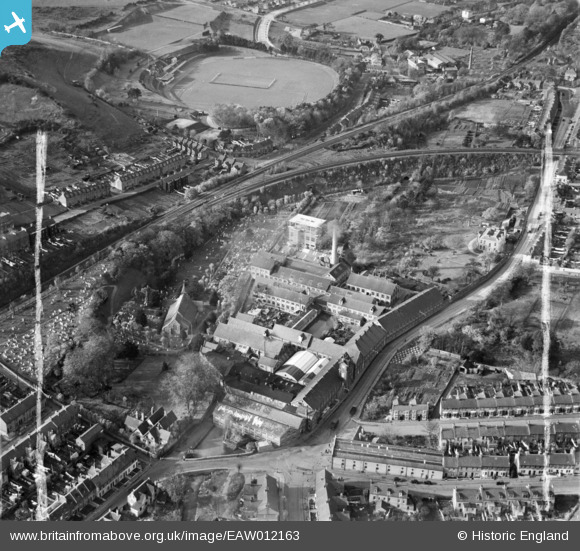
EAW012163 ENGLAND (1947). Buckland Paper Mill and St Andrew's Church, Buckland, 1947. This image was marked by Aerofilms Ltd for photo editing.
© Copyright OpenStreetMap contributors and licensed by the OpenStreetMap Foundation. 2026. Cartography is licensed as CC BY-SA.
Nearby Images (11)
EAW012163

EAW012160

EAW012161

EAW012164

EAW012158

EAW012162

EAW012159

EPW038165

EPW038164

EPW038166

EAW012165

Details
| Title | [EAW012163] Buckland Paper Mill and St Andrew's Church, Buckland, 1947. This image was marked by Aerofilms Ltd for photo editing. |
| Reference | EAW012163 |
| Date | 10-November-1947 |
| Link | |
| Place name | BUCKLAND |
| Parish | DOVER |
| District | |
| Country | ENGLAND |
| Easting / Northing | 630438, 142806 |
| Longitude / Latitude | 1.2944640160076, 51.137548872024 |
| National Grid Reference | TR304428 |
Pins

MB |
Wednesday 21st of September 2016 10:37:11 AM | |
|
MB |
Wednesday 21st of September 2016 10:35:36 AM | |
|
MB |
Wednesday 21st of September 2016 10:34:52 AM | |
|
MB |
Wednesday 21st of September 2016 10:32:28 AM | |
|
MB |
Wednesday 21st of September 2016 10:31:46 AM | |
'Corn' or grain mill in 1898. Possibly a roller flour mill, powered by water from the river Dour |
MB |
Wednesday 21st of September 2016 10:36:38 AM |
|
MB |
Wednesday 21st of September 2016 10:30:58 AM | |
|
jrussill |
Wednesday 15th of June 2016 11:44:32 AM |
User Comment Contributions

WW2 Anti tank pimples |
jrussill |
Wednesday 15th of June 2016 11:50:28 AM |