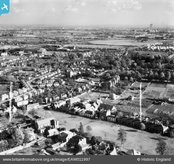
EAW011997 ENGLAND (1947). The town, West Drayton, from the west, 1947. This image was marked by Aerofilms Ltd for photo editing.
© Copyright OpenStreetMap contributors and licensed by the OpenStreetMap Foundation. 2026. Cartography is licensed as CC BY-SA.
Nearby Images (7)
Details
| Title | [EAW011997] The town, West Drayton, from the west, 1947. This image was marked by Aerofilms Ltd for photo editing. |
| Reference | EAW011997 |
| Date | 3-November-1947 |
| Link | |
| Place name | WEST DRAYTON |
| Parish | |
| District | |
| Country | ENGLAND |
| Easting / Northing | 505906, 179447 |
| Longitude / Latitude | -0.47395193098355, 51.503538926935 |
| National Grid Reference | TQ059794 |
Pins

brian |
Friday 3rd of January 2014 10:58:44 AM | |

brian |
Friday 3rd of January 2014 10:46:19 AM | |

brian |
Friday 3rd of January 2014 10:43:11 AM | |

brian |
Friday 3rd of January 2014 10:40:25 AM | |

brian |
Friday 3rd of January 2014 09:16:33 AM | |

brian |
Wednesday 1st of January 2014 02:33:40 PM | |

brian |
Wednesday 1st of January 2014 02:30:59 PM | |

brian |
Wednesday 1st of January 2014 02:28:46 PM | |

brian |
Wednesday 1st of January 2014 02:15:11 PM | |

brian |
Wednesday 1st of January 2014 02:10:05 PM | |

brian |
Wednesday 1st of January 2014 02:06:46 PM | |
Official designation : Admiralty Engineering Laboratory |

brian |
Friday 3rd of January 2014 03:14:06 PM |

brian |
Wednesday 1st of January 2014 02:01:38 PM | |
CORRECTION : Detailed as location in Warwick Road; was located in Brandville Road, West Drayton |

brian |
Friday 3rd of January 2014 09:26:09 AM |

brian |
Wednesday 1st of January 2014 01:55:58 PM | |
As can be observed a horticultural nursery existed between the school and nearby housing in Drayton Gardens; The nursery eventually closed its business and the ground was later taken over to expand the school recreational area,with the area used as a sports field. |

brian |
Friday 3rd of January 2014 09:12:29 AM |
West Drayton Primary School closed late 1970's [estimate]. Land utilised for housing. The school, still same name relocated to Kingston Lane, West Drayton. |

brian |
Friday 3rd of January 2014 10:37:34 AM |

brian |
Wednesday 1st of January 2014 01:52:47 PM | |

brian |
Wednesday 1st of January 2014 01:51:38 PM | |

brian |
Wednesday 1st of January 2014 01:50:25 PM | |

brian |
Wednesday 1st of January 2014 01:46:15 PM | |

brian |
Wednesday 1st of January 2014 01:45:35 PM | |

brian |
Wednesday 1st of January 2014 01:43:38 PM | |

brian |
Wednesday 1st of January 2014 01:41:55 PM | |

brian |
Wednesday 1st of January 2014 01:39:33 PM |


![[EAW011997] The town, West Drayton, from the west, 1947. This image was marked by Aerofilms Ltd for photo editing.](http://britainfromabove.org.uk/sites/all/libraries/aerofilms-images/public/100x100/EAW/011/EAW011997.jpg)
![[EAW012001] Wilkins and Campbell Britannia Works (Wax Refinery) and environs, West Drayton, 1947. This image was marked by Aerofilms Ltd for photo editing.](http://britainfromabove.org.uk/sites/all/libraries/aerofilms-images/public/100x100/EAW/012/EAW012001.jpg)
![[EAW011998] Wilkins and Campbell Britannia Works (Wax Refinery) and environs, West Drayton, 1947](http://britainfromabove.org.uk/sites/all/libraries/aerofilms-images/public/100x100/EAW/011/EAW011998.jpg)
![[EAW012000] Wilkins and Campbell Britannia Works (Wax Refinery) and The Green, West Drayton, 1947. This image was marked by Aerofilms Ltd for photo editing.](http://britainfromabove.org.uk/sites/all/libraries/aerofilms-images/public/100x100/EAW/012/EAW012000.jpg)
![[EAW011999] Wilkins and Campbell Britannia Works (Wax Refinery), West Drayton, 1947. This image was marked by Aerofilms Ltd for photo editing.](http://britainfromabove.org.uk/sites/all/libraries/aerofilms-images/public/100x100/EAW/011/EAW011999.jpg)
![[EAW012002] The town, West Drayton, 1947. This image was marked by Aerofilms Ltd for photo editing.](http://britainfromabove.org.uk/sites/all/libraries/aerofilms-images/public/100x100/EAW/012/EAW012002.jpg)
![[EAW012003] Wilkins and Campbell Britannia Works (Wax Refinery) and the town, West Drayton, 1947. This image was marked by Aerofilms Ltd for photo editing.](http://britainfromabove.org.uk/sites/all/libraries/aerofilms-images/public/100x100/EAW/012/EAW012003.jpg)