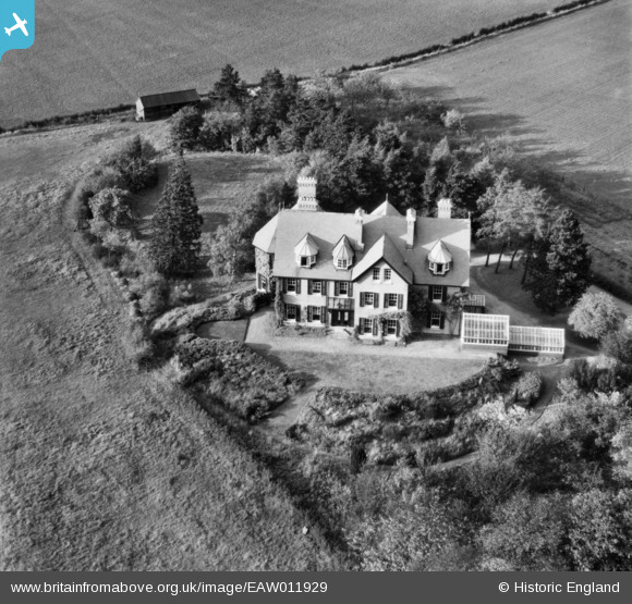
EAW011929 ENGLAND (1947). Girton Grange, Girton, 1947
© Copyright OpenStreetMap contributors and licensed by the OpenStreetMap Foundation. 2026. Cartography is licensed as CC BY-SA.
Nearby Images (10)
Details
| Title | [EAW011929] Girton Grange, Girton, 1947 |
| Reference | EAW011929 |
| Date | 15-October-1947 |
| Link | |
| Place name | GIRTON |
| Parish | GIRTON |
| District | |
| Country | ENGLAND |
| Easting / Northing | 542243, 261250 |
| Longitude / Latitude | 0.083021919395392, 52.230651154 |
| National Grid Reference | TL422613 |
Pins
Be the first to add a comment to this image!


![[EAW011929] Girton Grange, Girton, 1947](http://britainfromabove.org.uk/sites/all/libraries/aerofilms-images/public/100x100/EAW/011/EAW011929.jpg)
![[EPW000048] Girton College, Cambridge, from the south-west, 1920](http://britainfromabove.org.uk/sites/all/libraries/aerofilms-images/public/100x100/EPW/000/EPW000048.jpg)
![[EAW011918] Girton College and the surrounding area, Girton, 1947](http://britainfromabove.org.uk/sites/all/libraries/aerofilms-images/public/100x100/EAW/011/EAW011918.jpg)
![[EPW000041] Girton College, Cambridge, 1920](http://britainfromabove.org.uk/sites/all/libraries/aerofilms-images/public/100x100/EPW/000/EPW000041.jpg)
![[EAW011927] Girton College, Girton, 1947](http://britainfromabove.org.uk/sites/all/libraries/aerofilms-images/public/100x100/EAW/011/EAW011927.jpg)
![[EAW011921] Girton College, Girton, 1947](http://britainfromabove.org.uk/sites/all/libraries/aerofilms-images/public/100x100/EAW/011/EAW011921.jpg)
![[EAW011920] Girton College, Girton, 1947](http://britainfromabove.org.uk/sites/all/libraries/aerofilms-images/public/100x100/EAW/011/EAW011920.jpg)
![[EAW011917] Girton College and the surrounding area, Girton, 1947](http://britainfromabove.org.uk/sites/all/libraries/aerofilms-images/public/100x100/EAW/011/EAW011917.jpg)
![[EAW011925] Girton College, Girton, 1947](http://britainfromabove.org.uk/sites/all/libraries/aerofilms-images/public/100x100/EAW/011/EAW011925.jpg)
![[EAW011916] Girton College, Huntingdon Road (Roman Road) and the surrounding residential area, Girton, 1947](http://britainfromabove.org.uk/sites/all/libraries/aerofilms-images/public/100x100/EAW/011/EAW011916.jpg)