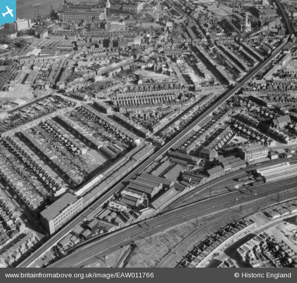
EAW011766 ENGLAND (1947). J. Stone and Company Limited Engineering Works and environs, Deptford, 1947
© Copyright OpenStreetMap contributors and licensed by the OpenStreetMap Foundation. 2026. Cartography is licensed as CC BY-SA.
Nearby Images (8)
Details
| Title | [EAW011766] J. Stone and Company Limited Engineering Works and environs, Deptford, 1947 |
| Reference | EAW011766 |
| Date | 9-October-1947 |
| Link | |
| Place name | DEPTFORD |
| Parish | |
| District | |
| Country | ENGLAND |
| Easting / Northing | 536653, 177720 |
| Longitude / Latitude | -0.031822690804926, 51.48141950091 |
| National Grid Reference | TQ367777 |
Pins

Leslie B |
Thursday 24th of March 2016 04:40:35 PM | |

Leslie B |
Tuesday 8th of March 2016 10:52:44 PM | |

Maggieheff |
Sunday 7th of October 2012 07:49:02 AM |


![[EAW011766] J. Stone and Company Limited Engineering Works and environs, Deptford, 1947](http://britainfromabove.org.uk/sites/all/libraries/aerofilms-images/public/100x100/EAW/011/EAW011766.jpg)
![[EAW011764] J. Stone and Company Limited Engineering Works and environs, Deptford, 1947](http://britainfromabove.org.uk/sites/all/libraries/aerofilms-images/public/100x100/EAW/011/EAW011764.jpg)
![[EAW011763] J. Stone and Company Limited Engineering Works and environs, Deptford, 1947](http://britainfromabove.org.uk/sites/all/libraries/aerofilms-images/public/100x100/EAW/011/EAW011763.jpg)
![[EAW011762] J. Stone and Company Limited Engineering Works, Deptford, 1947](http://britainfromabove.org.uk/sites/all/libraries/aerofilms-images/public/100x100/EAW/011/EAW011762.jpg)
![[EAW011767] J. Stone and Company Limited Engineering Works, Deptford, 1947](http://britainfromabove.org.uk/sites/all/libraries/aerofilms-images/public/100x100/EAW/011/EAW011767.jpg)
![[EAW011765] J. Stone and Company Limited Engineering Works, Deptford, 1947](http://britainfromabove.org.uk/sites/all/libraries/aerofilms-images/public/100x100/EAW/011/EAW011765.jpg)
![[EAW011761] J. Stone and Company Limited Engineering Work, Deptford, 1947](http://britainfromabove.org.uk/sites/all/libraries/aerofilms-images/public/100x100/EAW/011/EAW011761.jpg)
![[EAW011760] J. Stone and Company Limited Engineering Works and environs, Deptford, 1947](http://britainfromabove.org.uk/sites/all/libraries/aerofilms-images/public/100x100/EAW/011/EAW011760.jpg)