
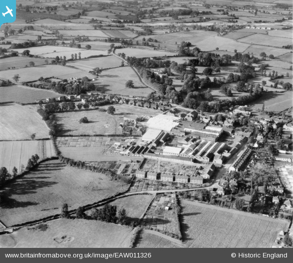
EAW011326 ENGLAND (1947). The Atlas Iron Works (Agricultural Implements), Earls Colne, 1947. This image was marked by Aerofilms Ltd for photo editing.
© Copyright OpenStreetMap contributors and licensed by the OpenStreetMap Foundation. 2026. Cartography is licensed as CC BY-SA.
Nearby Images (14)
EAW011326
, Earls Colne, 1947. This image was marked by Aerofilms Ltd for photo editing.")
EAW011323
 and the village, Earls Colne, 1947. This image was marked by Aerofilms Ltd for photo editing.")
EAW011322
, Earls Colne, 1947. This image was marked by Aerofilms Ltd for photo editing.")
EAW011328
, Earls Colne, from the north-west, 1947. This image was marked by Aerofilms Ltd for photo editing.")
EAW011333
, Earls Colne, 1947. This image was marked by Aerofilms Ltd for photo editing.")
EAW011325
, Earls Colne, 1947. This image was marked by Aerofilms Ltd for photo editing.")
EAW011321
, Earls Colne, 1947. This image was marked by Aerofilms Ltd for photo editing.")
EAW011329
, Earls Colne, from the south-west, 1947")
EAW011330
, Earls Colne, 1947. This image was marked by Aerofilms Ltd for photo editing.")
EAW011327
, Earls Colne, 1947. This image was marked by Aerofilms Ltd for photo editing.")
EAW011324
 and the village, Earls Colne, 1947. This image was marked by Aerofilms Ltd for photo editing.")
EAW011332
, Earls Colne, 1947. This image was marked by Aerofilms Ltd for photo editing.")
EAW011331
, Earls Colne, from the south-east, 1947. This image was marked by Aerofilms Ltd for photo editing.")
EAW043692

Details
| Title | [EAW011326] The Atlas Iron Works (Agricultural Implements), Earls Colne, 1947. This image was marked by Aerofilms Ltd for photo editing. |
| Reference | EAW011326 |
| Date | 1-October-1947 |
| Link | |
| Place name | EARLS COLNE |
| Parish | EARLS COLNE |
| District | |
| Country | ENGLAND |
| Easting / Northing | 585387, 228831 |
| Longitude / Latitude | 0.69653694302401, 51.926644129443 |
| National Grid Reference | TL854288 |
Pins

Colne Lad |
Tuesday 1st of December 2020 05:55:08 PM | |
|
fv43576 |
Thursday 16th of January 2020 04:53:06 PM | |
|
fv43576 |
Thursday 16th of January 2020 04:50:52 PM | |
|
Keith |
Sunday 17th of May 2015 08:44:44 PM | |
|
thomasmann |
Sunday 8th of June 2014 03:52:30 PM |