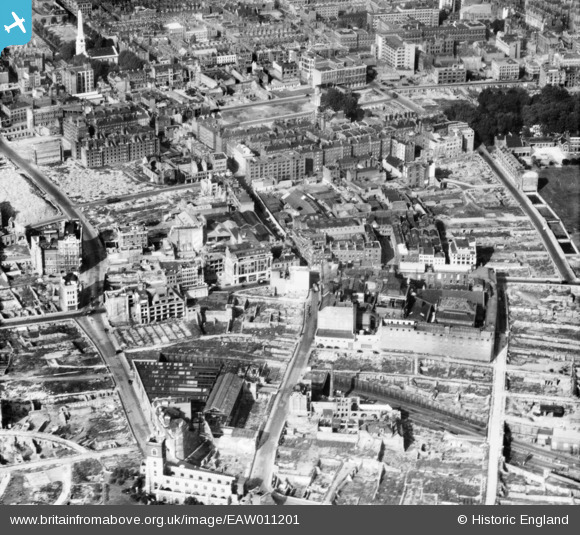
EAW011201 ENGLAND (1947). Cleared areas around the Whitbread Breweries on Whitecross Street following bomb damage, St Luke's, 1947
© Copyright OpenStreetMap contributors and licensed by the OpenStreetMap Foundation. 2026. Cartography is licensed as CC BY-SA.
Nearby Images (8)
Details
| Title | [EAW011201] Cleared areas around the Whitbread Breweries on Whitecross Street following bomb damage, St Luke's, 1947 |
| Reference | EAW011201 |
| Date | 30-September-1947 |
| Link | |
| Place name | ST LUKE'S |
| Parish | |
| District | |
| Country | ENGLAND |
| Easting / Northing | 532444, 181978 |
| Longitude / Latitude | -0.09080813381541, 51.520689753699 |
| National Grid Reference | TQ324820 |
Pins

Martin Devlin |
Tuesday 18th of October 2022 01:22:52 PM | |

Border Terrier |
Saturday 1st of May 2021 05:18:09 PM | |

Border Terrier |
Tuesday 21st of July 2020 07:09:16 PM | |

Border Terrier |
Tuesday 21st of July 2020 07:07:06 PM | |

Hermann the German |
Friday 25th of August 2017 06:16:05 PM | |

Blackwall |
Sunday 21st of September 2014 02:51:56 PM | |

Class31 |
Wednesday 23rd of July 2014 12:22:18 PM | |

billyfern |
Monday 23rd of June 2014 06:58:00 PM | |

billyfern |
Monday 23rd of June 2014 06:57:09 PM | |

billyfern |
Monday 23rd of June 2014 06:56:17 PM | |

billyfern |
Monday 23rd of June 2014 06:55:36 PM | |

Alan McFaden |
Thursday 12th of December 2013 01:54:06 PM | |

Alan McFaden |
Monday 11th of November 2013 10:02:10 AM |


![[EAW011201] Cleared areas around the Whitbread Breweries on Whitecross Street following bomb damage, St Luke's, 1947](http://britainfromabove.org.uk/sites/all/libraries/aerofilms-images/public/100x100/EAW/011/EAW011201.jpg)
![[EAW011117] Building ruins and cleared sites following bomb damage in the Fann Street and Golden Lane area, London, 1947. This image has been produced from a print.](http://britainfromabove.org.uk/sites/all/libraries/aerofilms-images/public/100x100/EAW/011/EAW011117.jpg)
![[EAW011367] Bomb damaged and cleared areas around Red Cross Street (the site of the Barbican Centre), London, 1947](http://britainfromabove.org.uk/sites/all/libraries/aerofilms-images/public/100x100/EAW/011/EAW011367.jpg)
![[EAW000514] Bomb damage and clearance around Moorgate Street Station, the Artillery Ground and environs, London, 1946](http://britainfromabove.org.uk/sites/all/libraries/aerofilms-images/public/100x100/EAW/000/EAW000514.jpg)
![[EAW011366] Cleared ground and piles of rubble at Whitecross Street, St Luke's, 1947](http://britainfromabove.org.uk/sites/all/libraries/aerofilms-images/public/100x100/EAW/011/EAW011366.jpg)
![[EAW011200] The New Artillery Ground and surrounding cleared sites following bomb damage, St Luke's, 1947](http://britainfromabove.org.uk/sites/all/libraries/aerofilms-images/public/100x100/EAW/011/EAW011200.jpg)
![[EAW011116] Cleared sites around Moorgate Street Station and Jewin Crescent following bomb damage, London, 1947](http://britainfromabove.org.uk/sites/all/libraries/aerofilms-images/public/100x100/EAW/011/EAW011116.jpg)
![[EAW041392] Union Glue & Gelatine Co Ltd Cransley Works on Garrett Street, St Luke's, 1951. This image has been produced from a print marked by Aerofilms Ltd for photo editing.](http://britainfromabove.org.uk/sites/all/libraries/aerofilms-images/public/100x100/EAW/041/EAW041392.jpg)


