
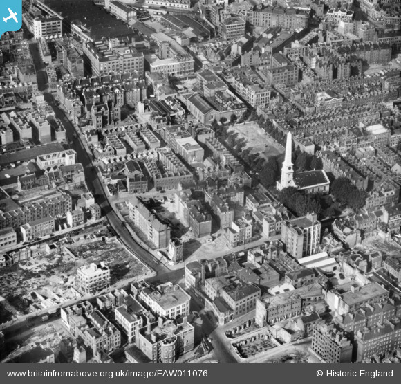
EAW011076 ENGLAND (1947). The area around Priestley House, St Luke's Church and environs, St Luke's, 1947
© Copyright OpenStreetMap contributors and licensed by the OpenStreetMap Foundation. 2026. Cartography is licensed as CC BY-SA.
Nearby Images (18)
EAW011076

EAW011215

EAW010074

EAW041389

EAW041385

EAW041386

EAW041384

EAW041388

EAW041391

EAW041387

EAW041390

EAW011118

EAW041393

EAW041392

EAW011119

EAW011075

EAW011214

EAW011366

Details
| Title | [EAW011076] The area around Priestley House, St Luke's Church and environs, St Luke's, 1947 |
| Reference | EAW011076 |
| Date | 30-September-1947 |
| Link | |
| Place name | ST LUKE'S |
| Parish | |
| District | |
| Country | ENGLAND |
| Easting / Northing | 532242, 182424 |
| Longitude / Latitude | -0.093550814295193, 51.524745512875 |
| National Grid Reference | TQ322824 |
Pins

billyfern |
Tuesday 24th of June 2014 08:01:15 PM | |
|
billyfern |
Tuesday 24th of June 2014 08:00:35 PM | |
|
billyfern |
Tuesday 24th of June 2014 07:59:29 PM | |
|
billyfern |
Tuesday 24th of June 2014 07:58:08 PM | |
|
billyfern |
Tuesday 24th of June 2014 07:57:29 PM | |
|
billyfern |
Tuesday 24th of June 2014 07:54:48 PM | |
|
billyfern |
Tuesday 24th of June 2014 07:53:54 PM | |
|
billyfern |
Tuesday 24th of June 2014 07:53:19 PM | |
|
billyfern |
Tuesday 24th of June 2014 07:49:19 PM | |
|
billyfern |
Tuesday 24th of June 2014 07:48:16 PM | |
|
billyfern |
Tuesday 24th of June 2014 07:47:57 PM | |
|
billyfern |
Tuesday 24th of June 2014 07:47:06 PM | |
|
glennhughz |
Thursday 10th of April 2014 11:35:42 AM | |

Alan McFaden |
Tuesday 12th of November 2013 06:16:59 PM |
