
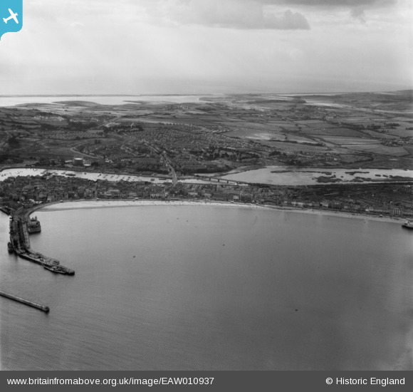
EAW010937 ENGLAND (1947). The town and countryside with Chesil Beach in the distance, Weymouth, from the east, 1947
© Copyright OpenStreetMap contributors and licensed by the OpenStreetMap Foundation. 2026. Cartography is licensed as CC BY-SA.
Nearby Images (5)
EAW010937

EAW002987

EAW010933

EAW010939

EAW010934

Details
| Title | [EAW010937] The town and countryside with Chesil Beach in the distance, Weymouth, from the east, 1947 |
| Reference | EAW010937 |
| Date | 24-September-1947 |
| Link | |
| Place name | WEYMOUTH |
| Parish | |
| District | |
| Country | ENGLAND |
| Easting / Northing | 368553, 79439 |
| Longitude / Latitude | -2.4445154495044, 50.613228359087 |
| National Grid Reference | SY686794 |
Pins

redmist |
Wednesday 31st of May 2023 08:01:30 PM | |
|
redmist |
Sunday 18th of September 2022 12:03:02 PM | |

Class31 |
Saturday 31st of May 2014 07:46:04 PM | |
|
Class31 |
Saturday 31st of May 2014 07:44:50 PM | |
|
Class31 |
Saturday 31st of May 2014 07:43:31 PM | |
|
Class31 |
Friday 30th of May 2014 09:48:13 PM |


User Comment Contributions

Weymouth, 09/10/2015 |
Class31 |
Tuesday 13th of October 2015 06:43:15 AM |