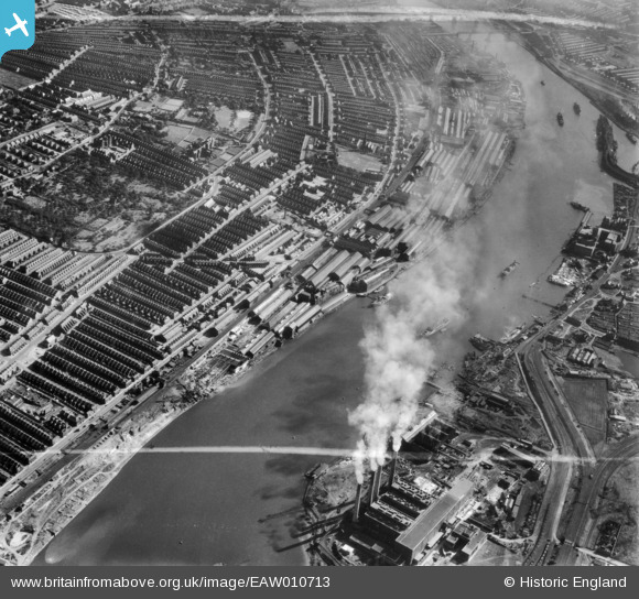
EAW010713 ENGLAND (1947). The Vickers-Armstrongs Ltd Elswick Works, River Tyne and environs, Elswick, 1947. This image was marked by Aerofilms Ltd for photo editing.
© Copyright OpenStreetMap contributors and licensed by the OpenStreetMap Foundation. 2026. Cartography is licensed as CC BY-SA.
Nearby Images (9)
Details
| Title | [EAW010713] The Vickers-Armstrongs Ltd Elswick Works, River Tyne and environs, Elswick, 1947. This image was marked by Aerofilms Ltd for photo editing. |
| Reference | EAW010713 |
| Date | 10-September-1947 |
| Link | |
| Place name | ELSWICK |
| Parish | |
| District | |
| Country | ENGLAND |
| Easting / Northing | 422446, 563202 |
| Longitude / Latitude | -1.6493977678927, 54.962866094022 |
| National Grid Reference | NZ224632 |
Pins

redmist |
Tuesday 20th of October 2020 12:09:20 PM | |

redmist |
Tuesday 20th of October 2020 12:04:50 PM | |

redmist |
Tuesday 20th of October 2020 12:04:27 PM | |

redmist |
Tuesday 20th of October 2020 12:03:59 PM | |

redmist |
Tuesday 20th of October 2020 12:03:34 PM | |

Josh Springer |
Thursday 2nd of April 2015 05:14:48 PM |


![[EAW010713] The Vickers-Armstrongs Ltd Elswick Works, River Tyne and environs, Elswick, 1947. This image was marked by Aerofilms Ltd for photo editing.](http://britainfromabove.org.uk/sites/all/libraries/aerofilms-images/public/100x100/EAW/010/EAW010713.jpg)
![[EAW010696] The Vickers-Armstrongs Ltd Elswick Works and environs, Elswick, 1947. This image was marked by Aerofilms Ltd for photo editing.](http://britainfromabove.org.uk/sites/all/libraries/aerofilms-images/public/100x100/EAW/010/EAW010696.jpg)
![[EAW010715] The Vickers-Armstrongs Ltd Elswick Works, River Tyne and environs, Elswick, 1947. This image was marked by Aerofilms Ltd for photo editing.](http://britainfromabove.org.uk/sites/all/libraries/aerofilms-images/public/100x100/EAW/010/EAW010715.jpg)
![[EAW010702] The Vickers-Armstrongs Ltd Elswick Works and environs, Elswick, 1947. This image was marked by Aerofilms Ltd for photo editing.](http://britainfromabove.org.uk/sites/all/libraries/aerofilms-images/public/100x100/EAW/010/EAW010702.jpg)
![[EAW010686] The Dunston Oil, Grease and Candle Factory, the Vickers-Armstrongs Ltd Elswick Works and environs, Elswick, 1947](http://britainfromabove.org.uk/sites/all/libraries/aerofilms-images/public/100x100/EAW/010/EAW010686.jpg)
![[EAW010697] The Vickers-Armstrongs Ltd Elswick Works and environs, Elswick, 1947. This image was marked by Aerofilms Ltd for photo editing.](http://britainfromabove.org.uk/sites/all/libraries/aerofilms-images/public/100x100/EAW/010/EAW010697.jpg)
![[EAW010712] The Vickers-Armstrongs Ltd Elswick Works, River Tyne and environs, Elswick, 1947](http://britainfromabove.org.uk/sites/all/libraries/aerofilms-images/public/100x100/EAW/010/EAW010712.jpg)
![[EAW010695] The Vickers-Armstrongs Ltd Elswick Works and environs, Elswick, 1947. This image was marked by Aerofilms Ltd for photo editing.](http://britainfromabove.org.uk/sites/all/libraries/aerofilms-images/public/100x100/EAW/010/EAW010695.jpg)
![[EAW010714] The Vickers-Armstrongs Ltd Elswick Works, River Tyne and environs, Elswick, 1947. This image was marked by Aerofilms Ltd for photo editing.](http://britainfromabove.org.uk/sites/all/libraries/aerofilms-images/public/100x100/EAW/010/EAW010714.jpg)