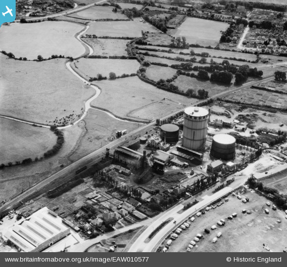
EAW010577 ENGLAND (1947). Bognor Regis Gas Works on Shripney Road, South Bersted, 1947
© Copyright OpenStreetMap contributors and licensed by the OpenStreetMap Foundation. 2026. Cartography is licensed as CC BY-SA.
Nearby Images (10)
Details
| Title | [EAW010577] Bognor Regis Gas Works on Shripney Road, South Bersted, 1947 |
| Reference | EAW010577 |
| Date | 3-September-1947 |
| Link | |
| Place name | SOUTH BERSTED |
| Parish | BERSTED |
| District | |
| Country | ENGLAND |
| Easting / Northing | 494180, 100535 |
| Longitude / Latitude | -0.66351800530704, 50.796152278019 |
| National Grid Reference | SU942005 |
Pins

redmist |
Saturday 2nd of July 2022 07:45:58 PM | |

redmist |
Saturday 2nd of July 2022 07:44:06 PM | |

redmist |
Saturday 2nd of July 2022 07:43:29 PM | |

redmist |
Saturday 2nd of July 2022 07:42:43 PM | |

Richard Dawson |
Monday 6th of October 2014 06:05:10 PM |


![[EAW010577] Bognor Regis Gas Works on Shripney Road, South Bersted, 1947](http://britainfromabove.org.uk/sites/all/libraries/aerofilms-images/public/100x100/EAW/010/EAW010577.jpg)
![[EAW010578] Bognor Regis Gas Works on Shripney Road, South Bersted, 1947](http://britainfromabove.org.uk/sites/all/libraries/aerofilms-images/public/100x100/EAW/010/EAW010578.jpg)
![[EAW010580] Bognor Regis Gas Works on Shripney Road, South Bersted, 1947](http://britainfromabove.org.uk/sites/all/libraries/aerofilms-images/public/100x100/EAW/010/EAW010580.jpg)
![[EAW010579] Bognor Regis Gas Works on Shripney Road, South Bersted, 1947](http://britainfromabove.org.uk/sites/all/libraries/aerofilms-images/public/100x100/EAW/010/EAW010579.jpg)
![[EAW010576] Bognor Regis Gas Works on Shripney Road, South Bersted, 1947](http://britainfromabove.org.uk/sites/all/libraries/aerofilms-images/public/100x100/EAW/010/EAW010576.jpg)
![[EAW010581] Bognor Regis Gas Works on Shripney Road, South Bersted, 1947](http://britainfromabove.org.uk/sites/all/libraries/aerofilms-images/public/100x100/EAW/010/EAW010581.jpg)
![[EAW010575] Bognor Regis Gas Works on Shripney Road, South Bersted, 1947](http://britainfromabove.org.uk/sites/all/libraries/aerofilms-images/public/100x100/EAW/010/EAW010575.jpg)
![[EAW010574] Bognor Regis Gas Works and caravan park adjacent to Shripney Road, South Bersted, 1947](http://britainfromabove.org.uk/sites/all/libraries/aerofilms-images/public/100x100/EAW/010/EAW010574.jpg)
![[EAW010573] Bognor Regis Gas Works and caravan park adjacent to Shripney Road, South Bersted, 1947](http://britainfromabove.org.uk/sites/all/libraries/aerofilms-images/public/100x100/EAW/010/EAW010573.jpg)
![[EAW010572] Bognor Regis Gas Works and caravan park adjacent to Shripney Road, South Bersted, 1947](http://britainfromabove.org.uk/sites/all/libraries/aerofilms-images/public/100x100/EAW/010/EAW010572.jpg)