© Copyright OpenStreetMap contributors and licensed by the OpenStreetMap Foundation. 2026. Cartography is licensed as CC BY-SA.
Details
| Title |
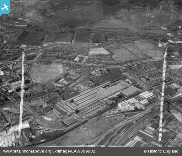
[EAW009982] The Tube Products Ltd Tube Works on Pope's Lane and environs, Oldbury, 1947. This image was marked by Aerofilms Ltd for photo editing. |
| Reference |
EAW009982 |
| Date |
31-August-1947 |
| Link |
|
| Place name |
OLDBURY |
| Parish |
|
| District |
|
| Country |
ENGLAND |
| Easting / Northing |
399909, 289293 |
| Longitude / Latitude |
-2.0013407050527, 52.501171690825 |
| National Grid Reference |
SO999893 |
Pins
 My family lived in this house during the 1940's, 50's and early 60's. A coal fire, gas stove and outside cold water supply and toilet. All of the houses along this stretch were demolished as part of a slum clearance plan in the 60's. The property was actually two 'semi-detached' houses and ours, the larger half was 115 Birmingham Road. Holland's Garage & coach company is on the opposite side of the Birmingham Road. Happy days as children and no worries as long as you could get across the dual carriageway in one piece. Something I only failed to do once!
We went to St Francis Xavier Junior & Infants School in Pinfold Street in Oldbury. Out of school, play areas included the canal and the railway lines at the far side of Blakeley Hall Road and the local parks Fraser Street was at the bottom of the garden.It was a cul-de-sac ('Cul-de-sac' was written under Fraser Street on the road sign and we never knew what it meant. Of course we now know that it's French for Fraser Street :-). |

Joe Bloggs |
Monday 3rd of June 2019 11:12:28 PM |


![[EAW009982] The Tube Products Ltd Tube Works on Pope's Lane and environs, Oldbury, 1947. This image was marked by Aerofilms Ltd for photo editing.](http://britainfromabove.org.uk/sites/all/libraries/aerofilms-images/public/100x100/EAW/009/EAW009982.jpg)
![[EAW009983] The Tube Products Ltd Tube Works on Pope's Lane and environs, Oldbury, 1947. This image was marked by Aerofilms Ltd for photo editing.](http://britainfromabove.org.uk/sites/all/libraries/aerofilms-images/public/100x100/EAW/009/EAW009983.jpg)
![[EAW009979] The Tube Products Ltd Tube Works on Pope's Lane, Oldbury, 1947. This image was marked by Aerofilms Ltd for photo editing.](http://britainfromabove.org.uk/sites/all/libraries/aerofilms-images/public/100x100/EAW/009/EAW009979.jpg)
![[EAW009984] The Tube Products Ltd Tube Works on Pope's Lane and environs, Oldbury, 1947. This image was marked by Aerofilms Ltd for photo editing.](http://britainfromabove.org.uk/sites/all/libraries/aerofilms-images/public/100x100/EAW/009/EAW009984.jpg)
![[EPW044526] Tube Products Ltd Tube Works on Pope's Lane and environs, Tat Bank, 1934](http://britainfromabove.org.uk/sites/all/libraries/aerofilms-images/public/100x100/EPW/044/EPW044526.jpg)
![[EAW009980] The Tube Products Ltd Tube Works on Pope's Lane, Oldbury, 1947. This image was marked by Aerofilms Ltd for photo editing.](http://britainfromabove.org.uk/sites/all/libraries/aerofilms-images/public/100x100/EAW/009/EAW009980.jpg)
![[EPW044525] Tube Products Ltd Tube Works on Pope's Lane and environs, Tat Bank, 1934](http://britainfromabove.org.uk/sites/all/libraries/aerofilms-images/public/100x100/EPW/044/EPW044525.jpg)
![[EAW009981] The Tube Products Ltd Tube Works on Pope's Lane, Oldbury, 1947. This image was marked by Aerofilms Ltd for photo editing.](http://britainfromabove.org.uk/sites/all/libraries/aerofilms-images/public/100x100/EAW/009/EAW009981.jpg)
![[EPW047980] The Tube Products Ltd Tube Works on Pope's Lane, Oldbury, 1935](http://britainfromabove.org.uk/sites/all/libraries/aerofilms-images/public/100x100/EPW/047/EPW047980.jpg)
![[EPW047976] The Tube Products Ltd Tube Works on Pope's Lane, Oldbury, 1935](http://britainfromabove.org.uk/sites/all/libraries/aerofilms-images/public/100x100/EPW/047/EPW047976.jpg)
![[EAW009986] The Tube Products Ltd Tube Works on Pope's Lane and environs, Oldbury, from the north-west, 1947. This image was marked by Aerofilms Ltd for photo editing.](http://britainfromabove.org.uk/sites/all/libraries/aerofilms-images/public/100x100/EAW/009/EAW009986.jpg)
![[EPW055773] The Tube Products Ltd Works, Tat Bank, 1937. This image has been produced from a damaged negative.](http://britainfromabove.org.uk/sites/all/libraries/aerofilms-images/public/100x100/EPW/055/EPW055773.jpg)
![[EPW047979] The Tube Products Ltd Tube Works on Pope's Lane, Oldbury, 1935](http://britainfromabove.org.uk/sites/all/libraries/aerofilms-images/public/100x100/EPW/047/EPW047979.jpg)
![[EPW047978] The Tube Products Ltd Tube Works on Pope's Lane, Oldbury, 1935](http://britainfromabove.org.uk/sites/all/libraries/aerofilms-images/public/100x100/EPW/047/EPW047978.jpg)
![[EPW047975] The Tube Products Ltd Tube Works on Pope's Lane, Oldbury, 1935](http://britainfromabove.org.uk/sites/all/libraries/aerofilms-images/public/100x100/EPW/047/EPW047975.jpg)
![[EPW047981] The Tube Products Ltd Tube Works on Pope's Lane, Oldbury, 1935](http://britainfromabove.org.uk/sites/all/libraries/aerofilms-images/public/100x100/EPW/047/EPW047981.jpg)
![[EPW047977] The Tube Products Ltd Tube Works on Pope's Lane, Oldbury, 1935](http://britainfromabove.org.uk/sites/all/libraries/aerofilms-images/public/100x100/EPW/047/EPW047977.jpg)
![[EPW055769] The Tube Products Ltd Works, Tat Bank, 1937](http://britainfromabove.org.uk/sites/all/libraries/aerofilms-images/public/100x100/EPW/055/EPW055769.jpg)
![[EPW055772] The Tube Products Ltd Works, Tat Bank, 1937](http://britainfromabove.org.uk/sites/all/libraries/aerofilms-images/public/100x100/EPW/055/EPW055772.jpg)
![[EPW044521] Tube Products Ltd Tube Works on Pope's Lane, Tat Bank, 1934](http://britainfromabove.org.uk/sites/all/libraries/aerofilms-images/public/100x100/EPW/044/EPW044521.jpg)
![[EPW055770] The Tube Products Ltd Works, Tat Bank, 1937](http://britainfromabove.org.uk/sites/all/libraries/aerofilms-images/public/100x100/EPW/055/EPW055770.jpg)
![[EPW055768] The Tube Products Ltd Works, Tat Bank, 1937. This image has been produced from a damaged negative.](http://britainfromabove.org.uk/sites/all/libraries/aerofilms-images/public/100x100/EPW/055/EPW055768.jpg)
![[EPW044522] Tube Products Ltd Tube Works on Pope's Lane, Tat Bank, 1934](http://britainfromabove.org.uk/sites/all/libraries/aerofilms-images/public/100x100/EPW/044/EPW044522.jpg)
![[EPW055771] The Tube Products Ltd Works, Tat Bank, 1937](http://britainfromabove.org.uk/sites/all/libraries/aerofilms-images/public/100x100/EPW/055/EPW055771.jpg)
![[EPW055774] The Tube Products Ltd Works, Tat Bank, 1937. This image has been affected by flare.](http://britainfromabove.org.uk/sites/all/libraries/aerofilms-images/public/100x100/EPW/055/EPW055774.jpg)
![[EAW009985] The Tube Products Ltd Tube Works on Pope's Lane and environs, Oldbury, 1947. This image was marked by Aerofilms Ltd for photo editing.](http://britainfromabove.org.uk/sites/all/libraries/aerofilms-images/public/100x100/EAW/009/EAW009985.jpg)