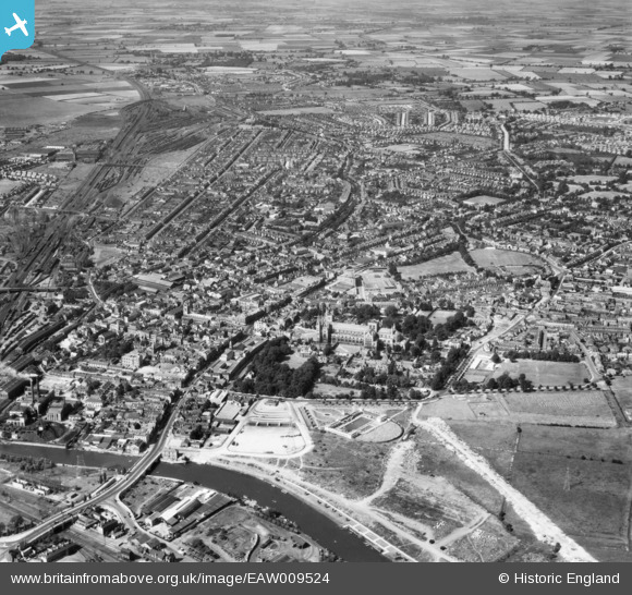
EAW009524 ENGLAND (1947). The city, Peterborough, from the south-east, 1947
    © Copyright OpenStreetMap contributors and licensed by the OpenStreetMap Foundation. 2025. Cartography is licensed as CC BY-SA.
  
Nearby Images (19)
Details
| Title | [EAW009524] The city, Peterborough, from the south-east, 1947 | 
| Reference | EAW009524 | 
| Date | 18-August-1947 | 
| Link | |
| Place name | PETERBOROUGH | 
| Parish | |
| District | |
| Country | ENGLAND | 
| Easting / Northing | 519474, 298415 | 
| Longitude / Latitude | -0.2369574099697, 52.57006123315 | 
| National Grid Reference | TL195984 | 
Pins
|  Whatever these are (stacked bricks?), they were in this location from at least 1944-1954. Possibly a building project delayed/abandoned due to WW2? This site became the Wirrina in the late 60s and is now ARU. |   Matt Aldred edob.mattaldred.com | Friday 8th of March 2024 03:12:17 PM | 
|  The little triangular cemetery that disappeared under the Queensgate shopping centre. |   dch_control | Sunday 29th of January 2023 12:42:38 PM | 
|  Great Northern Hotel. |   dch_control | Sunday 29th of January 2023 12:40:28 PM | 
|  Old Perkins Engines factory. |   dch_control | Sunday 29th of January 2023 12:38:16 PM | 
|  Peterborough Town Hall.  About to be relocated (2023) to new offices in Fletton Quays, close to the site of the old Peterborough East railway station. |   dch_control | Sunday 29th of January 2023 12:35:54 PM | 
|  Peterborough Power Station.  Later modernised with a single large chimney.  Coal brought in by rail.  Later, all demolished and replaced by modern gas-turbine power station in Fengate.  That is currently (2023) only used as an emergency stand-by generator. |   dch_control | Sunday 29th of January 2023 12:33:25 PM | 
|  The Patent Ladder Company |   dch_control | Sunday 29th of January 2023 12:30:48 PM | 
|  Peterborough East Station |   dch_control | Sunday 29th of January 2023 12:29:45 PM | 
|  English's(?) Timber Yard |   dch_control | Sunday 29th of January 2023 12:29:00 PM | 
|  The Customs House |   dch_control | Sunday 29th of January 2023 12:27:39 PM | 
|  Peterborough Cattle Market |   dch_control | Sunday 29th of January 2023 12:26:58 PM | 
|  The Lido outdoor swimming pool |   dch_control | Sunday 29th of January 2023 12:25:25 PM | 
|  Crescent signal box |   wiferiley | Saturday 24th of July 2021 07:47:59 PM | 
|  The Museum, formerly Peterborough Infirmary |   wiferiley | Saturday 24th of July 2021 07:46:51 PM | 
|  The 'Queen Adelaide' |   wiferiley | Saturday 24th of July 2021 07:24:58 PM | 
|  The Corn Exchange |   wiferiley | Saturday 24th of July 2021 07:24:07 PM | 
|  Madeley  House, King's School boarding house. To  the residents the 'Pig & Whistle' |   wiferiley | Saturday 24th of July 2021 07:18:49 PM | 
|  King's  School |   wiferiley | Saturday 24th of July 2021 07:16:16 PM | 
|  Thacker's Row |   wiferiley | Saturday 24th of July 2021 03:16:45 PM | 
|  St Mark's Church  Hall, in Bright Street |   wiferiley | Saturday 24th of July 2021 03:15:42 PM | 
|  Church Hose, 28 Cromwell Road. Now demolished. |   wiferiley | Saturday 24th of July 2021 03:14:43 PM | 
|  Pell & Parker. Bicycle wholesale supplies |   wiferiley | Saturday 24th of July 2021 03:13:27 PM | 
|  LMS Locomotive shed Spital. |   wiferiley | Saturday 17th of July 2021 07:37:10 PM | 
|  St Marks Church |   wiferiley | Saturday 17th of July 2021 03:16:12 PM | 
|  County school, for girls. |   wiferiley | Saturday 17th of July 2021 03:15:19 PM | 
|  Walton level crossing |   wiferiley | Friday 16th of July 2021 10:37:59 AM | 
|  New England locomotive sheds |   wiferiley | Friday 16th of July 2021 10:36:08 AM | 
|  Great  Northern Railway, LNER at this period, District Engineers complex with drawing and admin offices. |   wiferiley | Friday 16th of July 2021 10:34:52 AM | 
|  'Fairways' a great shop |   wiferiley | Friday 16th of July 2021 10:19:05 AM | 
|  Paston railway crossing. |   Andrew Richardson | Monday 15th of June 2020 10:38:41 AM | 
|  Dump of Concrete Obstacles TBC |   Sparky | Tuesday 22nd of August 2017 09:25:42 AM | 
|  Peterborough railway station, infamous for many years for the S curves at both ends of the station causing the high speed trains of the day to have to observe a 25 mph speed limit through it. |   John Wass | Tuesday 9th of September 2014 03:04:47 PM | 
| Class31 | Wednesday 11th of June 2014 08:04:55 AM | 
User Comment Contributions
| Peterborough Cathedral, properly the Cathedral Church of St Peter, St Paul and St Andrew – also known as Saint Peter's Cathedral, Peterborough , 10/06/2014 | Class31 | Wednesday 11th of June 2014 08:24:50 AM | 
 
             
  ![[EAW009524] The city, Peterborough, from the south-east, 1947](http://britainfromabove.org.uk/sites/all/libraries/aerofilms-images/public/100x100/EAW/009/EAW009524.jpg) 
  
                                          ![[EAW005690] The Peterborough Lido, Peterborough, 1947](http://britainfromabove.org.uk/sites/all/libraries/aerofilms-images/public/100x100/EAW/005/EAW005690.jpg) 
 ![[EPW044910] The Cathedral Church of St Peter, St Paul and St Andrew, the London Road Bridge and environs, Peterborough, 1934](http://britainfromabove.org.uk/sites/all/libraries/aerofilms-images/public/100x100/EPW/044/EPW044910.jpg) 
 ![[EPW039168] The Cathedral Church of St Peter, St Paul and St Andrew and the city centre, Peterborough, from the south, 1932. This image has been produced from a copy-negative.](http://britainfromabove.org.uk/sites/all/libraries/aerofilms-images/public/100x100/EPW/039/EPW039168.jpg) 
 ![[EPW009852] The Cathedral Church of St Peter, St Paul and St Andrew, Peterborough, 1924. This image has been produced from a copy-negative.](http://britainfromabove.org.uk/sites/all/libraries/aerofilms-images/public/100x100/EPW/009/EPW009852.jpg) 
 ![[EPW044922] London Road Bridge, Broad Bridge Street and environs, Peterborough, 1934](http://britainfromabove.org.uk/sites/all/libraries/aerofilms-images/public/100x100/EPW/044/EPW044922.jpg) 
 ![[EPW050307] St Peter's Cathedral and the city centre, Peterborough, 1936](http://britainfromabove.org.uk/sites/all/libraries/aerofilms-images/public/100x100/EPW/050/EPW050307.jpg) 
 ![[EPW044909] The Cathedral Church of St Peter, St Paul and St Andrew and environs, Peterborough, 1934](http://britainfromabove.org.uk/sites/all/libraries/aerofilms-images/public/100x100/EPW/044/EPW044909.jpg) 
 ![[EPW044907] The Cathedral Church of St Peter, St Paul and St Andrew and the city centre, Peterborough, 1934. This image has been affected by flare.](http://britainfromabove.org.uk/sites/all/libraries/aerofilms-images/public/100x100/EPW/044/EPW044907.jpg) 
 ![[EPW039170] The Cathedral Church of St Peter, St Paul and St Andrew, Peterborough, 1932. This image has been produced from a copy-negative.](http://britainfromabove.org.uk/sites/all/libraries/aerofilms-images/public/100x100/EPW/039/EPW039170.jpg) 
 ![[EAW005687] Peterborough Cathedral and the city centre, Peterborough, 1947](http://britainfromabove.org.uk/sites/all/libraries/aerofilms-images/public/100x100/EAW/005/EAW005687.jpg) 
 ![[EPW009853] The Cathedral Church of St Peter, St Paul and St Andrew, Peterborough, 1924. This image has been produced from a copy-negative.](http://britainfromabove.org.uk/sites/all/libraries/aerofilms-images/public/100x100/EPW/009/EPW009853.jpg) 
 ![[EPW044920] London Road Bridge, the River Nene and environs, Peterborough, 1934](http://britainfromabove.org.uk/sites/all/libraries/aerofilms-images/public/100x100/EPW/044/EPW044920.jpg) 
 ![[EPW044918] London Road Bridge, the River Nene and environs, Peterborough, 1934](http://britainfromabove.org.uk/sites/all/libraries/aerofilms-images/public/100x100/EPW/044/EPW044918.jpg) 
 ![[EPW044908] The Cathedral Church of St Peter, St Paul and St Andrew and the city centre, Peterborough, 1934. This image has been affected by flare.](http://britainfromabove.org.uk/sites/all/libraries/aerofilms-images/public/100x100/EPW/044/EPW044908.jpg) 
 ![[EAW005689] Peterborough Cathedral and the city centre, Peterborough, 1947](http://britainfromabove.org.uk/sites/all/libraries/aerofilms-images/public/100x100/EAW/005/EAW005689.jpg) 
 ![[EPW044921] London Road Bridge, Broad Bridge Street and environs, Peterborough, 1934](http://britainfromabove.org.uk/sites/all/libraries/aerofilms-images/public/100x100/EPW/044/EPW044921.jpg) 
 ![[EPW044919] London Road Bridge, Broad Bridge Street and environs, Peterborough, 1934](http://britainfromabove.org.uk/sites/all/libraries/aerofilms-images/public/100x100/EPW/044/EPW044919.jpg) 
 ![[EPW044905] Broad Bridge Street, the cathedral and environs, Peterborough, 1934](http://britainfromabove.org.uk/sites/all/libraries/aerofilms-images/public/100x100/EPW/044/EPW044905.jpg)