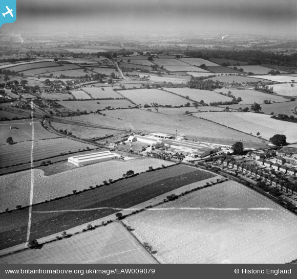
EAW009079 ENGLAND (1947). Leaderflush Ltd Flush Door Works and environs, Trowell, from the south, 1947. This image was marked by Aerofilms Ltd for photo editing.
© Copyright OpenStreetMap contributors and licensed by the OpenStreetMap Foundation. 2026. Cartography is licensed as CC BY-SA.
Nearby Images (40)
Details
| Title | [EAW009079] Leaderflush Ltd Flush Door Works and environs, Trowell, from the south, 1947. This image was marked by Aerofilms Ltd for photo editing. |
| Reference | EAW009079 |
| Date | 14-August-1947 |
| Link | |
| Place name | TROWELL |
| Parish | TROWELL |
| District | |
| Country | ENGLAND |
| Easting / Northing | 448712, 339081 |
| Longitude / Latitude | -1.2749702177419, 52.946586038437 |
| National Grid Reference | SK487391 |
Pins

redmist |
Friday 13th of January 2023 01:19:55 PM | |

redmist |
Friday 13th of January 2023 01:19:32 PM | |

Class31 |
Thursday 7th of August 2014 06:33:30 AM | |

Class31 |
Thursday 7th of August 2014 06:32:57 AM | |

Class31 |
Thursday 7th of August 2014 06:31:48 AM |


![[EAW009079] Leaderflush Ltd Flush Door Works and environs, Trowell, from the south, 1947. This image was marked by Aerofilms Ltd for photo editing.](http://britainfromabove.org.uk/sites/all/libraries/aerofilms-images/public/100x100/EAW/009/EAW009079.jpg)
![[EAW007221] The Leaderflush Ltd Flush Door Works and the village, Trowell, from the south-east, 1947. This image was marked by Aerofilms Ltd for photo editing.](http://britainfromabove.org.uk/sites/all/libraries/aerofilms-images/public/100x100/EAW/007/EAW007221.jpg)
![[EAW002224] Leaderflush Ltd Flush Door Works and Stapleford Road, Trowell, 1946](http://britainfromabove.org.uk/sites/all/libraries/aerofilms-images/public/100x100/EAW/002/EAW002224.jpg)
![[EAW008221] Leaderflush Ltd Flush Door Works, Trowell, from the south, 1947. This image was marked by Aerofilms Ltd for photo editing.](http://britainfromabove.org.uk/sites/all/libraries/aerofilms-images/public/100x100/EAW/008/EAW008221.jpg)
![[EAW008225] Leaderflush Ltd Flush Door Works, Trowell, from the south-east, 1947. This image was marked by Aerofilms Ltd for photo editing.](http://britainfromabove.org.uk/sites/all/libraries/aerofilms-images/public/100x100/EAW/008/EAW008225.jpg)
![[EAW007225] The Leaderflush Ltd Flush Door Works and the surrounding countryside, Trowell, from the south-west, 1947. This image was marked by Aerofilms Ltd for photo editing.](http://britainfromabove.org.uk/sites/all/libraries/aerofilms-images/public/100x100/EAW/007/EAW007225.jpg)
![[EAW002228] Warehouse building opposite Leaderflush Ltd Flush Door Works, Trowell, 1946](http://britainfromabove.org.uk/sites/all/libraries/aerofilms-images/public/100x100/EAW/002/EAW002228.jpg)
![[EAW002229] Leaderflush Ltd Flush Door Works and environs, Trowell, from the south-east, 1946](http://britainfromabove.org.uk/sites/all/libraries/aerofilms-images/public/100x100/EAW/002/EAW002229.jpg)
![[EAW002223] Leaderflush Ltd Flush Door Works, Trowell, 1946](http://britainfromabove.org.uk/sites/all/libraries/aerofilms-images/public/100x100/EAW/002/EAW002223.jpg)
![[EAW008224] Leaderflush Ltd Flush Door Works, Trowell, 1947. This image was marked by Aerofilms Ltd for photo editing.](http://britainfromabove.org.uk/sites/all/libraries/aerofilms-images/public/100x100/EAW/008/EAW008224.jpg)
![[EAW007223] The Leaderflush Ltd Flush Door Works and adjacent housing, Trowell, from the north-west, 1947](http://britainfromabove.org.uk/sites/all/libraries/aerofilms-images/public/100x100/EAW/007/EAW007223.jpg)
![[EAW009086] Leaderflush Ltd Flush Door Works and environs, Trowell, from the south, 1947. This image was marked by Aerofilms Ltd for photo editing.](http://britainfromabove.org.uk/sites/all/libraries/aerofilms-images/public/100x100/EAW/009/EAW009086.jpg)
![[EAW008223] Leaderflush Ltd Flush Door Works, Trowell, from the south-west, 1947](http://britainfromabove.org.uk/sites/all/libraries/aerofilms-images/public/100x100/EAW/008/EAW008223.jpg)
![[EAW002226] Leaderflush Ltd Flush Door Works, Trowell, 1946](http://britainfromabove.org.uk/sites/all/libraries/aerofilms-images/public/100x100/EAW/002/EAW002226.jpg)
![[EAW008226] Leaderflush Ltd Flush Door Works, Trowell, from the south-west, 1947](http://britainfromabove.org.uk/sites/all/libraries/aerofilms-images/public/100x100/EAW/008/EAW008226.jpg)
![[EAW009083] Leaderflush Ltd Flush Door Works, Stapleford Road and environs, Trowell, 1947. This image was marked by Aerofilms Ltd for photo editing.](http://britainfromabove.org.uk/sites/all/libraries/aerofilms-images/public/100x100/EAW/009/EAW009083.jpg)
![[EAW009085] Leaderflush Ltd Flush Door Works and environs, Trowell, 1947. This image was marked by Aerofilms Ltd for photo editing.](http://britainfromabove.org.uk/sites/all/libraries/aerofilms-images/public/100x100/EAW/009/EAW009085.jpg)
![[EAW007228] The Leaderflush Ltd Flush Door Works, Trowell, from the east, 1947. This image was marked by Aerofilms Ltd for photo editing.](http://britainfromabove.org.uk/sites/all/libraries/aerofilms-images/public/100x100/EAW/007/EAW007228.jpg)
![[EAW009084] Leaderflush Ltd Flush Door Works, Trowell, 1947](http://britainfromabove.org.uk/sites/all/libraries/aerofilms-images/public/100x100/EAW/009/EAW009084.jpg)
![[EAW008222] Leaderflush Ltd Flush Door Works, Trowell, from the south-west, 1947](http://britainfromabove.org.uk/sites/all/libraries/aerofilms-images/public/100x100/EAW/008/EAW008222.jpg)
![[EAW009080] Leaderflush Ltd Flush Door Works and environs, Trowell, 1947. This image was marked by Aerofilms Ltd for photo editing.](http://britainfromabove.org.uk/sites/all/libraries/aerofilms-images/public/100x100/EAW/009/EAW009080.jpg)
![[EAW007227] The Leaderflush Ltd Flush Door Works and the surrounding countryside, Trowell, from the south-west, 1947. This image was marked by Aerofilms Ltd for photo editing.](http://britainfromabove.org.uk/sites/all/libraries/aerofilms-images/public/100x100/EAW/007/EAW007227.jpg)
![[EAW007226] The Leaderflush Ltd Flush Door Works, Trowell, from the east, 1947. This image was marked by Aerofilms Ltd for photo editing.](http://britainfromabove.org.uk/sites/all/libraries/aerofilms-images/public/100x100/EAW/007/EAW007226.jpg)
![[EAW002230] Leaderflush Ltd Flush Door Works, Trowell, 1946](http://britainfromabove.org.uk/sites/all/libraries/aerofilms-images/public/100x100/EAW/002/EAW002230.jpg)
![[EPW060936] Leaderflush Ltd Flush Door Works and environs, Trowell, 1939](http://britainfromabove.org.uk/sites/all/libraries/aerofilms-images/public/100x100/EPW/060/EPW060936.jpg)
![[EAW007230] The Leaderflush Ltd Flush Door Works, adjacent housing and the surrounding countryside, Trowell, from the north-west, 1947](http://britainfromabove.org.uk/sites/all/libraries/aerofilms-images/public/100x100/EAW/007/EAW007230.jpg)
![[EAW002231] Leaderflush Ltd Flush Door Works, Trowell, 1946](http://britainfromabove.org.uk/sites/all/libraries/aerofilms-images/public/100x100/EAW/002/EAW002231.jpg)
![[EPW060932] Leaderflush Ltd Flush Door Works, Trowell, 1939](http://britainfromabove.org.uk/sites/all/libraries/aerofilms-images/public/100x100/EPW/060/EPW060932.jpg)
![[EAW002227] Leaderflush Ltd Flush Door Works, Trowell, 1946](http://britainfromabove.org.uk/sites/all/libraries/aerofilms-images/public/100x100/EAW/002/EAW002227.jpg)
![[EAW002225] Leaderflush Ltd Flush Door Works, Trowell, 1946](http://britainfromabove.org.uk/sites/all/libraries/aerofilms-images/public/100x100/EAW/002/EAW002225.jpg)
![[EPW060931] Leaderflush Ltd Flush Door Works, Trowell, 1939](http://britainfromabove.org.uk/sites/all/libraries/aerofilms-images/public/100x100/EPW/060/EPW060931.jpg)
![[EPW060937] Leaderflush Ltd Flush Door Works, Trowell, 1939](http://britainfromabove.org.uk/sites/all/libraries/aerofilms-images/public/100x100/EPW/060/EPW060937.jpg)
![[EAW008219] Leaderflush Ltd Flush Door Works, Trowell, 1947. This image was marked by Aerofilms Ltd for photo editing.](http://britainfromabove.org.uk/sites/all/libraries/aerofilms-images/public/100x100/EAW/008/EAW008219.jpg)
![[EAW008220] Leaderflush Ltd Flush Door Works, Trowell, 1947. This image was marked by Aerofilms Ltd for photo editing.](http://britainfromabove.org.uk/sites/all/libraries/aerofilms-images/public/100x100/EAW/008/EAW008220.jpg)
![[EPW060933] Leaderflush Ltd Flush Door Works and environs, Trowell, 1939](http://britainfromabove.org.uk/sites/all/libraries/aerofilms-images/public/100x100/EPW/060/EPW060933.jpg)
![[EAW007229] The Leaderflush Ltd Flush Door Works and adjacent housing, Trowell, from the west, 1947. This image was marked by Aerofilms Ltd for photo editing.](http://britainfromabove.org.uk/sites/all/libraries/aerofilms-images/public/100x100/EAW/007/EAW007229.jpg)
![[EPW060935] Leaderflush Ltd Flush Door Works and environs, Trowell, 1939](http://britainfromabove.org.uk/sites/all/libraries/aerofilms-images/public/100x100/EPW/060/EPW060935.jpg)
![[EPW060934] Leaderflush Ltd Flush Door Works, Trowell, 1939](http://britainfromabove.org.uk/sites/all/libraries/aerofilms-images/public/100x100/EPW/060/EPW060934.jpg)
![[EAW007222] The Leaderflush Ltd Flush Door Works and Stapleford Hill, Trowell, from the north-west, 1947](http://britainfromabove.org.uk/sites/all/libraries/aerofilms-images/public/100x100/EAW/007/EAW007222.jpg)
![[EAW007224] The Leaderflush Ltd Flush Door Works and the surrounding countryside, Trowell, from the north, 1947](http://britainfromabove.org.uk/sites/all/libraries/aerofilms-images/public/100x100/EAW/007/EAW007224.jpg)