
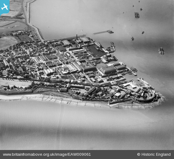
EAW009061 ENGLAND (1947). Garrison Point Fort, Sheerness Docks and Blue Town, Sheerness, 1947
© Copyright OpenStreetMap contributors and licensed by the OpenStreetMap Foundation. 2026. Cartography is licensed as CC BY-SA.
Nearby Images (6)
EAW009061

EAW037832

EAW037834

EAW009062

EAW037835

EAW021075

Details
| Title | [EAW009061] Garrison Point Fort, Sheerness Docks and Blue Town, Sheerness, 1947 |
| Reference | EAW009061 |
| Date | 12-August-1947 |
| Link | |
| Place name | SHEERNESS |
| Parish | |
| District | |
| Country | ENGLAND |
| Easting / Northing | 591022, 175332 |
| Longitude / Latitude | 0.74911787738469, 51.444224235277 |
| National Grid Reference | TQ910753 |
Pins

cptpies |
Friday 6th of October 2017 09:17:25 AM | |
|
cptpies |
Friday 6th of October 2017 09:16:51 AM | |
|
cptpies |
Friday 6th of October 2017 09:16:02 AM | |
|
ken |
Tuesday 21st of July 2015 04:36:17 PM | |
|
Al |
Thursday 30th of January 2014 12:34:33 AM | |
In the First World War, these were two 4.7 inch gun towers. There are plans and photographs at: http://www.kenthistoryforum.co.uk/index.php?topic=10066.0 |
Lynda Tubbs |
Tuesday 29th of July 2014 01:58:18 PM |
|
Al |
Thursday 30th of January 2014 12:32:49 AM | |
|
Al |
Thursday 30th of January 2014 12:31:15 AM |
User Comment Contributions

The gun emplacements shown in this image are documented with photographs and original plans: http://www.kenthistoryforum.co.uk/index.php?topic=10066.0 |
Lynda Tubbs |
Tuesday 29th of July 2014 02:02:00 PM |