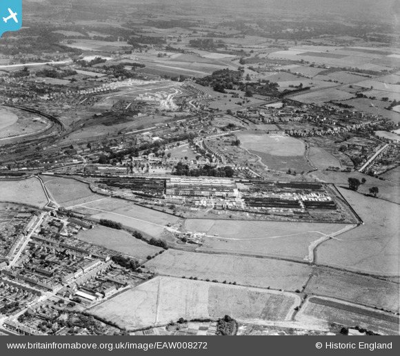
EAW008272 ENGLAND (1947). The Southern Railway Works and New Town, Ashford, 1947
© Copyright OpenStreetMap contributors and licensed by the OpenStreetMap Foundation. 2026. Cartography is licensed as CC BY-SA.
Nearby Images (7)
Details
| Title | [EAW008272] The Southern Railway Works and New Town, Ashford, 1947 |
| Reference | EAW008272 |
| Date | 15-July-1947 |
| Link | |
| Place name | ASHFORD |
| Parish | |
| District | |
| Country | ENGLAND |
| Easting / Northing | 601595, 141411 |
| Longitude / Latitude | 0.88192738494264, 51.135902610094 |
| National Grid Reference | TR016414 |
Pins

Matt Aldred edob.mattaldred.com |
Thursday 26th of November 2020 09:10:02 PM | |

Sparky |
Sunday 1st of October 2017 10:28:26 PM | |

Sparky |
Sunday 1st of October 2017 10:27:27 PM | |

B.R.E.L.I.E. |
Monday 5th of January 2015 10:40:31 PM | |

B.R.E.L.I.E. |
Monday 5th of January 2015 10:37:23 PM | |

B.R.E.L.I.E. |
Monday 5th of January 2015 10:33:19 PM | |

B.R.E.L.I.E. |
Monday 5th of January 2015 10:28:22 PM | |

B.R.E.L.I.E. |
Monday 5th of January 2015 10:25:47 PM | |

B.R.E.L.I.E. |
Monday 5th of January 2015 10:23:58 PM | |

B.R.E.L.I.E. |
Monday 5th of January 2015 10:21:01 PM | |

B.R.E.L.I.E. |
Monday 5th of January 2015 10:19:33 PM | |

B.R.E.L.I.E. |
Monday 5th of January 2015 10:18:29 PM | |

B.R.E.L.I.E. |
Monday 5th of January 2015 10:16:58 PM | |

B.R.E.L.I.E. |
Monday 5th of January 2015 10:15:11 PM | |

B.R.E.L.I.E. |
Monday 5th of January 2015 10:13:21 PM | |

B.R.E.L.I.E. |
Monday 5th of January 2015 10:12:12 PM | |

B.R.E.L.I.E. |
Monday 5th of January 2015 10:09:46 PM | |

B.R.E.L.I.E. |
Monday 5th of January 2015 10:04:52 PM | |

B.R.E.L.I.E. |
Monday 5th of January 2015 10:02:51 PM | |

B.R.E.L.I.E. |
Monday 5th of January 2015 09:36:31 PM | |

B.R.E.L.I.E. |
Monday 5th of January 2015 09:34:29 PM | |

B.R.E.L.I.E. |
Monday 5th of January 2015 09:33:26 PM | |

B.R.E.L.I.E. |
Monday 5th of January 2015 09:32:24 PM | |

B.R.E.L.I.E. |
Monday 5th of January 2015 09:31:18 PM | |

B.R.E.L.I.E. |
Monday 5th of January 2015 09:30:08 PM | |

B.R.E.L.I.E. |
Monday 5th of January 2015 09:28:11 PM | |

B.R.E.L.I.E. |
Monday 5th of January 2015 09:07:46 PM | |

B.R.E.L.I.E. |
Monday 7th of April 2014 08:30:46 PM | |

B.R.E.L.I.E. |
Monday 7th of April 2014 08:19:24 PM | |

B.R.E.L.I.E. |
Monday 7th of April 2014 08:14:09 PM | |

B.R.E.L.I.E. |
Monday 7th of April 2014 04:36:58 PM | |

B.R.E.L.I.E. |
Monday 7th of April 2014 02:27:53 PM | |

B.R.E.L.I.E. |
Monday 7th of April 2014 02:26:25 PM | |

B.R.E.L.I.E. |
Monday 7th of April 2014 02:23:29 PM | |

B.R.E.L.I.E. |
Monday 7th of April 2014 02:20:28 PM | |

B.R.E.L.I.E. |
Monday 7th of April 2014 02:17:25 PM | |

B.R.E.L.I.E. |
Monday 7th of April 2014 02:16:26 PM | |

B.R.E.L.I.E. |
Monday 7th of April 2014 02:11:53 PM | |

B.R.E.L.I.E. |
Monday 7th of April 2014 02:09:00 PM | |

B.R.E.L.I.E. |
Monday 7th of April 2014 02:07:02 PM | |

B.R.E.L.I.E. |
Monday 7th of April 2014 02:02:58 PM | |

B.R.E.L.I.E. |
Monday 7th of April 2014 01:53:13 PM | |

B.R.E.L.I.E. |
Monday 7th of April 2014 01:47:21 PM | |

B.R.E.L.I.E. |
Monday 7th of April 2014 01:46:27 PM | |

B.R.E.L.I.E. |
Monday 7th of April 2014 01:44:03 PM | |

B.R.E.L.I.E. |
Monday 7th of April 2014 01:41:32 PM | |

B.R.E.L.I.E. |
Monday 7th of April 2014 01:39:20 PM |


![[EAW008272] The Southern Railway Works and New Town, Ashford, 1947](http://britainfromabove.org.uk/sites/all/libraries/aerofilms-images/public/100x100/EAW/008/EAW008272.jpg)
![[EAW008278] The Southern Railway Works and New Town, Ashford, 1947](http://britainfromabove.org.uk/sites/all/libraries/aerofilms-images/public/100x100/EAW/008/EAW008278.jpg)
![[EAW008277] The Southern Railway Works, Ashford, 1947](http://britainfromabove.org.uk/sites/all/libraries/aerofilms-images/public/100x100/EAW/008/EAW008277.jpg)
![[EPW000703] South East Railway Company Works, Ashford, 1920](http://britainfromabove.org.uk/sites/all/libraries/aerofilms-images/public/100x100/EPW/000/EPW000703.jpg)
![[EAW008271] The Southern Railway Works and New Town, Ashford, 1947](http://britainfromabove.org.uk/sites/all/libraries/aerofilms-images/public/100x100/EAW/008/EAW008271.jpg)
![[EAW008279] The Southern Railway Works and New Town, Ashford, 1947](http://britainfromabove.org.uk/sites/all/libraries/aerofilms-images/public/100x100/EAW/008/EAW008279.jpg)
![[EAW008270] The Southern Railway Works, Ashford, from the north-west, 1947](http://britainfromabove.org.uk/sites/all/libraries/aerofilms-images/public/100x100/EAW/008/EAW008270.jpg)