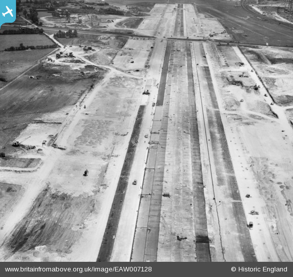
EAW007128 ENGLAND (1947). The main runway of Bristol Filton Airport under construction, Catbrain, 1947
© Copyright OpenStreetMap contributors and licensed by the OpenStreetMap Foundation. 2026. Cartography is licensed as CC BY-SA.
Nearby Images (13)
Details
| Title | [EAW007128] The main runway of Bristol Filton Airport under construction, Catbrain, 1947 |
| Reference | EAW007128 |
| Date | 11-June-1947 |
| Link | |
| Place name | CATBRAIN |
| Parish | ALMONDSBURY |
| District | |
| Country | ENGLAND |
| Easting / Northing | 358812, 180178 |
| Longitude / Latitude | -2.5936783297394, 51.518537509234 |
| National Grid Reference | ST588802 |
Pins

redmist |
Saturday 14th of November 2020 03:47:25 PM | |

redmist |
Saturday 14th of November 2020 03:46:21 PM | |

Billy Turner |
Thursday 24th of March 2016 06:42:58 PM |


![[EAW007128] The main runway of Bristol Filton Airport under construction, Catbrain, 1947](http://britainfromabove.org.uk/sites/all/libraries/aerofilms-images/public/100x100/EAW/007/EAW007128.jpg)
![[EAW026944] The runway at Bristol Filton Airport, Catbrain, 1949. This image has been produced from a damaged negative.](http://britainfromabove.org.uk/sites/all/libraries/aerofilms-images/public/100x100/EAW/026/EAW026944.jpg)
![[EAW004177] The western end of the main runway of Bristol Filton Airport under construction, Catbrain, 1947](http://britainfromabove.org.uk/sites/all/libraries/aerofilms-images/public/100x100/EAW/004/EAW004177.jpg)
![[EAW001551] Charlton Common and the surrounding countryside, Catbrain, 1946](http://britainfromabove.org.uk/sites/all/libraries/aerofilms-images/public/100x100/EAW/001/EAW001551.jpg)
![[EAW007143] The main runway under construction at Bristol Filton Airport, Catbrain, 1947](http://britainfromabove.org.uk/sites/all/libraries/aerofilms-images/public/100x100/EAW/007/EAW007143.jpg)
![[EAW026945] The runway at Bristol Filton Airport, Catbrain, 1949. This image has been produced from a damaged negative.](http://britainfromabove.org.uk/sites/all/libraries/aerofilms-images/public/100x100/EAW/026/EAW026945.jpg)
![[EAW004186] Cranes handling aggregates during building works at Bristol Filton Airport, Catbrain, 1947](http://britainfromabove.org.uk/sites/all/libraries/aerofilms-images/public/100x100/EAW/004/EAW004186.jpg)
![[EAW009948] Bristol Filton Airport under construction, Catbrain, 1947](http://britainfromabove.org.uk/sites/all/libraries/aerofilms-images/public/100x100/EAW/009/EAW009948.jpg)
![[EAW026943] The runway at Bristol Filton Airport, Catbrain, 1949](http://britainfromabove.org.uk/sites/all/libraries/aerofilms-images/public/100x100/EAW/026/EAW026943.jpg)
![[EAW026946] The runway at Bristol Filton Airport, Catbrain, 1949. This image has been produced from a damaged negative.](http://britainfromabove.org.uk/sites/all/libraries/aerofilms-images/public/100x100/EAW/026/EAW026946.jpg)
![[EAW004190] The main runway of Bristol Filton Airport under construction, Catbrain, 1947](http://britainfromabove.org.uk/sites/all/libraries/aerofilms-images/public/100x100/EAW/004/EAW004190.jpg)
![[EAW004187] The main runway of Bristol Filton Airport under construction, Catbrain, 1947](http://britainfromabove.org.uk/sites/all/libraries/aerofilms-images/public/100x100/EAW/004/EAW004187.jpg)
![[EAW013921] Bristol Filton Airport, Catbrain, 1948. This image has been produced from a print.](http://britainfromabove.org.uk/sites/all/libraries/aerofilms-images/public/100x100/EAW/013/EAW013921.jpg)
