
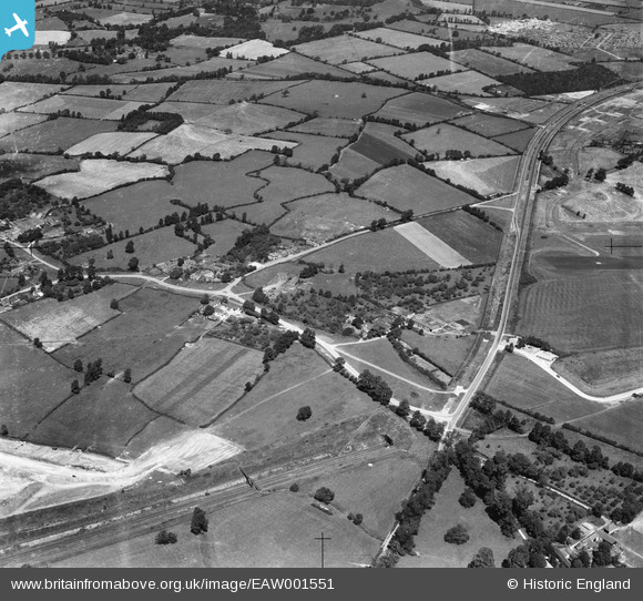
EAW001551 ENGLAND (1946). Charlton Common and the surrounding countryside, Catbrain, 1946
© Copyright OpenStreetMap contributors and licensed by the OpenStreetMap Foundation. 2026. Cartography is licensed as CC BY-SA.
Nearby Images (11)
EAW001551

EAW009948

EAW026943

EAW007128

EAW026944

EAW013921

EAW004177

EAW026942

EAW026945

EAW004186

EAW007143

Details
| Title | [EAW001551] Charlton Common and the surrounding countryside, Catbrain, 1946 |
| Reference | EAW001551 |
| Date | 15-July-1946 |
| Link | |
| Place name | CATBRAIN |
| Parish | ALMONDSBURY |
| District | |
| Country | ENGLAND |
| Easting / Northing | 358695, 180160 |
| Longitude / Latitude | -2.5953625439304, 51.51836710745 |
| National Grid Reference | ST587802 |
Pins

John Wass |
Tuesday 22nd of November 2016 08:28:39 PM | |
|
Buzzard |
Wednesday 3rd of June 2015 04:12:16 PM | |
|
Buzzard |
Wednesday 3rd of June 2015 04:10:57 PM | |

Class31 |
Wednesday 3rd of June 2015 07:03:40 AM | |
|
Class31 |
Wednesday 3rd of June 2015 07:03:06 AM | |
|
Buzzard |
Tuesday 19th of May 2015 10:59:46 PM | |
|
Buzzard |
Tuesday 19th of May 2015 10:57:39 PM | |
|
MB |
Sunday 15th of September 2013 10:16:14 AM | |
This is the Filton By-pass (all that remains now is Highwood Lane (Bus Lane). |
Buzzard |
Wednesday 3rd of June 2015 04:08:28 PM |
|
MB |
Sunday 15th of September 2013 10:12:31 AM |
User Comment Contributions
The upper tag is not Cribbs Causeway because that road crosses a railway cutting at Henbury Station, not a tunnel. In fact, the road tagged is the old Filton Bypass, which was bisected by the Brabazon Runway a couple of years after this photo was taken. |
Geoff |
Tuesday 19th of May 2015 10:46:20 PM |
Spot on! |
Buzzard |
Tuesday 19th of May 2015 10:46:20 PM |