
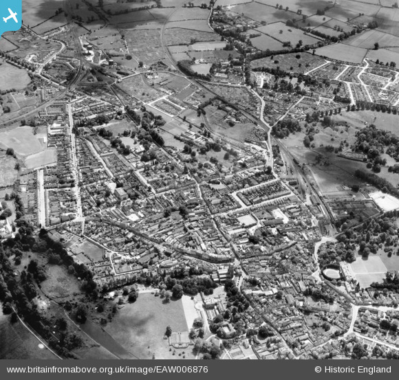
EAW006876 ENGLAND (1947). The town, Cirencester, 1947
© Copyright OpenStreetMap contributors and licensed by the OpenStreetMap Foundation. 2026. Cartography is licensed as CC BY-SA.
Nearby Images (5)
EAW006876

EAW031678

EPW022414

EPW022409

EAW006878

Details
| Title | [EAW006876] The town, Cirencester, 1947 |
| Reference | EAW006876 |
| Date | 10-June-1947 |
| Link | |
| Place name | CIRENCESTER |
| Parish | CIRENCESTER |
| District | |
| Country | ENGLAND |
| Easting / Northing | 402401, 201693 |
| Longitude / Latitude | -1.9652438453228, 51.71350444512 |
| National Grid Reference | SP024017 |
Pins

Tippy |
Tuesday 29th of March 2016 09:11:53 PM | |
|
gBr |
Sunday 30th of August 2015 06:42:46 PM | |
|
gBr |
Sunday 30th of August 2015 06:36:42 PM | |
|
gBr |
Sunday 30th of August 2015 06:30:55 PM | |
|
gBr |
Sunday 30th of August 2015 06:28:54 PM | |
|
gBr |
Sunday 30th of August 2015 06:25:50 PM | |
|
gBr |
Sunday 30th of August 2015 06:24:33 PM | |

Maurice |
Friday 19th of September 2014 06:04:25 PM | |

Alan McFaden |
Wednesday 21st of May 2014 10:01:52 PM | |
|
Alan McFaden |
Wednesday 21st of May 2014 10:00:44 PM | |
|
Alan McFaden |
Wednesday 21st of May 2014 09:59:49 PM | |
|
SydM |
Saturday 8th of March 2014 05:49:21 PM | |
Lynda Tubbs |
Thursday 13th of February 2014 01:52:53 PM | |
|
Nowy Paul |
Sunday 5th of January 2014 04:25:20 PM |


