
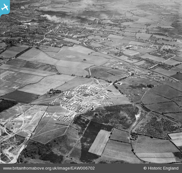
EAW006702 ENGLAND (1947). Camp Bewdley (Burlish Camp) and environs, Stourport-on-Severn, 1947
© Copyright OpenStreetMap contributors and licensed by the OpenStreetMap Foundation. 2025. Cartography is licensed as CC BY-SA.
Nearby Images (4)
EAW006702
 and environs, Stourport-on-Severn, 1947")
EAW006699
, Stourport-on-Severn, 1947")
EAW006697
, Stourport-on-Severn, 1947")
EAW006698
, Stourport-on-Severn, 1947")
Details
| Title | [EAW006702] Camp Bewdley (Burlish Camp) and environs, Stourport-on-Severn, 1947 |
| Reference | EAW006702 |
| Date | 28-May-1947 |
| Link | |
| Place name | STOURPORT-ON-SEVERN |
| Parish | STOURPORT-ON-SEVERN |
| District | |
| Country | ENGLAND |
| Easting / Northing | 380844, 273379 |
| Longitude / Latitude | -2.2813115183536, 52.357752773252 |
| National Grid Reference | SO808734 |
Pins

NickY |
Wednesday 22nd of February 2023 08:07:36 AM | |
|
NickY |
Wednesday 22nd of February 2023 08:05:52 AM | |
|
Peter Cook |
Sunday 12th of July 2015 05:41:46 PM | |
|
Geoffs |
Wednesday 10th of June 2015 07:25:00 PM | |
|
Geoffs |
Wednesday 10th of June 2015 07:21:33 PM | |
|
The_Engineer |
Tuesday 28th of October 2014 05:30:20 PM | |
|
The_Engineer |
Tuesday 28th of October 2014 03:58:39 PM | |
|
The_Engineer |
Tuesday 28th of October 2014 03:57:26 PM | |
|
The_Engineer |
Tuesday 28th of October 2014 03:55:35 PM | |
|
The_Engineer |
Tuesday 28th of October 2014 03:54:19 PM | |
|
The_Engineer |
Tuesday 28th of October 2014 03:51:35 PM | |
|
The_Engineer |
Tuesday 28th of October 2014 03:48:56 PM | |
|
The_Engineer |
Tuesday 28th of October 2014 03:47:29 PM | |
|
The_Engineer |
Tuesday 28th of October 2014 03:44:10 PM | |
|
The_Engineer |
Tuesday 28th of October 2014 03:43:39 PM |
User Comment Contributions
Bewdley Camp was built as a hospital for the expected casualties following D-Day. Some people dwelling there into 1960's before closure and designation as a country park. Some of the old concrete pathways and rainwater soak-aways can still be seen 2014 |
The_Engineer |
Tuesday 28th of October 2014 03:56:42 PM |
The camp's history is summarised on the following web site: burlishcamp.co.uk/the-camp-at-war/ |
MB |
Sunday 10th of November 2013 10:13:59 AM |